 Ford 1839 map

|

|
|
|
item:- JandMN (100_3) image:- © see bottom of page |
click to enlarge |
|
|
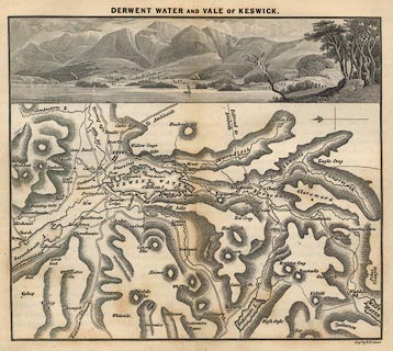
Map, uncoloured engraving, Derwent Water and Vale of
Keswick, engraved by W H Lizars, published by Charles
Thurnam, Carlisle, and by R Groombridge, 5 Paternoster Row,
London, 3rd edn 1843.
Above the map is an engraving of the lake and the mountains to the west, matching the presentation of the map. Tipped in between pp.52-53 in a guide book, A Description of Scenery in the Lake District, by Rev William Ford, 1839-43. |
||

|
Ford 1839 map | |
| map feature:- | vignettes & north point & up is W & rivers & lakes & relief & hill hachuring & settlements & roads | |
| inscription:- |
printed top
DERWENT WATER AND VALE OF KESWICK |
|
| inscription:- |
printed bottom right
Engd. by W. H. Lizars |
|
| wxh, sheet:- | 20.5x18cm | |
| wxh, map:- | 171x108mm | |