 Ford 1839 map

|

|
|
|
item:- JandMN (100_2) image:- © see bottom of page |
click to enlarge |
|
|
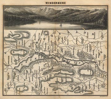
Map, uncoloured engraving, Windermere, engraved by W H
Lizars, published by Charles Thurnam, Carlisle, and by R
Groombridge, 5 Paternoster Row, London, 3rd edn 1843.
Beside the map is an engraving of Windermere lake. The scene is upright as the sheet is tipped into the book; the map is sideways on the sheet, but labelled to be read with North at the top, ie left. Tipped in between pp.24-25 in a guide book, A Description of Scenery in the Lake District, by Rev William Ford, 1839-43. |
||

|
Ford 1839 map | |
| map feature:- | vignettes & north point & up is N & rivers & lakes & relief & hill hachuring & woods & parks & county & settlements & roads | |
| inscription:- |
printed top
WINDERMERE |
|
| inscription:- |
printed bottom right
Engd. by W. H. Lizars |
|
| wxh, sheet:- | 18x20cm | |
| wxh, map:- | 108x176mm | |