 Cole and Roper 1805

|

|
|
|
map type:- Cole and Roper 1805 |
|
|
|
Maps, Westmoreland, scale about 6 miles to 1 inch, and
Cumberland, scale about 8 miles to 1 inch, by G Cole, and
other counties, engraved by J Roper, published by Vernor,
Hood and Sharpe, Poultry, London, 1805; published 1805-58.
Published in 'The British Atlas; comprising a complete set of County Maps, of England and Wales; with a general map of Navigable Rivers and Canals; and Plans of Cities and principal Towns. London: Printed for Vernor, Hood and Sharpe; Longman, Hurst, Rees, and Orme; J. Harris; J. Cuthell; J. Cundee; W. Faden; J. and A. Arch; Crosby and Co; J. Richardson; and J. M. Richardson, 1810'. The atlas has title page, list of contents, 2 general maps, 56 county maps, 21 town plans; its size is 8 5/8 x 11 ins. Originally issued with the 'Beauties of England and Wales' by E W Brayley and J Britton. Published in 'English Topography: or, A Series of Historical and Statistical descriptions of the several Counties of England and Wales. Accompanied by a map of each county ... 'Thee, O my Country! All my Soul reveres, And Admiration swells with ripening years.' London: Printed for Baldwin, Cradock, and Joy, Paternoster Row. 1816.' by Joseph Nightingale, London, 1816. Published in another edition 'English Topography ... Published by James Goodwin & Thomas McLean.' 1820. A poor lithographic copy published in 'Collins' Railway and Pedestrian Atlas of England containing forty-three maps, with all railways and roads accurately laid down ... London: Darton & Co., 58, Holborn Hill,' 1858. In the 1858 copy all imprints etc are removed; the atlas size is 5 1/2 x 7 ins. Other sheets in the series cover Lancashire and the rest of England and Wales. |
||
|
(map example JandMN (4))
|
||
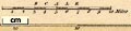
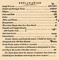
| map feature:- | title cartouche & plain cartouche & compass rose & up is N & scale line & lat and long scales & table of symbols & sea plain (?) & coast form lines & rivers & lakes & relief & hill hachuring & parks & county & wards (hundreds) & settlements & roads | |
| inscription:- |
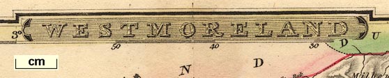
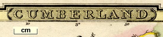
printed title cartouche, top centre
WESTMORELAND |
|
| inscription:- |
printed bottom, left, centre, right
Engraved by J. Roper from a drawing by G. Cole. / London : Published by Vernor, Hood & Sharpe, Poultry. March 1st. 1807. / to accompany the Beauties of England & Wales. |
|
| inscription:- |
watermark:
J WHATMAN / 1805 |
|
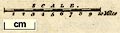
| scale line:- | 10 miles = 42.5 mm | |
| scale:- | 1 to 380000 ? (1 to 378669 from scale line) | |
| wxh, sheet:- | 27x21.5cm | |
| wxh, map:- | 231x177mm | |
|
||
|
||
|
||
| references:- |
Brayley, E W & Britton, J:: Beauties of England and Wales : 1810: British Atlas: Vernor, Hood and Sharpe & Longman, Hurst, Rees, and Orme & Harris, J & Cuthell, J & Cundee, J & Faden, W & Arch, J and A & Crosby and Co & Richardson, J & Richardson, J M Nightingale, Joseph: 1816: English Topography: Baldwin, Cradock, and Joy (London) Nightingale, Joseph: 1820: English Topography: Goodwin, James & McLean, Thomas (London) Collins, Henry G: 1858: Collins' Railway and Pedestrian Atlas of England: Darton and Co (London) |
|
| sources:- |
Chubb 1927 (CCCXXXIX) JandMN Collection Wordsworth Trust Collection Armitt Library private collection Kendal Library Maps Carlisle Library Maps |
|
| items seen (illustrated items in bold):- | ||

|
Armitt Library : ALMC2008.14.43 -- map -- Westmoreland | |
|
|
Armitt Library : ALMC2008.14.45 -- map -- Westmoreland | |
|
|
Carlisle Library : Map 118 -- street map -- Carlisle | |
|
|
Carlisle Library : Map 141 -- map -- Cumberland | |
|
|
Carlisle Library : Map 176 -- map -- Westmoreland | |
|
|
Carlisle Library : Map 177 -- map -- Westmoreland | |
|
|
Carlisle Library : Map 234 -- street map -- Carlisle | |
|
|
Carlisle Library : Map 252 -- street map -- Carlisle | |
|
|
Carlisle Library : Map 328 -- map -- Cumberland | |
|
|
Carlisle Library : Map 343 -- street map -- Carlisle | |
|
|
Dove Cottage : 2007.38.8 -- map -- Westmoreland | |
|
|
Dove Cottage : 2007.38.68 -- map -- Cumberland | |
|
|
Dove Cottage : 2007.38.70 -- map -- Westmoreland | |
|
|
Dove Cottage : 2007.38.71 -- map -- Westmoreland | |
|
|
Dove Cottage : 2009.81.6 -- map -- Westmoreland | |
|
|
Dove Cottage : 2009.81.16 -- map -- Cumberland | |
|
|
JandMN (4) -- map -- Westmoreland | |
|
|
JandMN (221) -- map -- Cumberland | |
|
|
Kendal Library : Map 55 -- map -- Westmoreland | |
|
|
Kendal Library : Map 68 -- map -- Westmoreland | |
|
|
Kendal Library : Map 69 -- map -- Westmoreland | |
|
|
Kendal Library : Map 70 -- map -- Westmoreland | |
|
|
private collection (7) -- map -- Westmoreland | |
|
|
private collection (8) -- map -- Cumberland | |
|
|
private collection (9) -- map -- Lancashire | |