 Cole and Roper 1805

|

|
|
|
item:- Dove Cottage : 2007.38.71 image:- © see bottom of page |
click to enlarge |
|
|
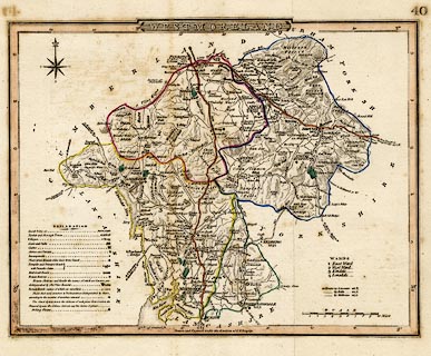
Map, hand coloured engraving, Westmoreland ie
Westmorland, scale about 6 miles to 1 inch, by G Cole,
engraved by J Roper, 1805, published London, 1858?
Originally drawn to accompany the Beauties of England and Wales by E W Brayely and J Britton; plate no.40 is added; and electoral data, polling places, etc, are added; imprints are erased. (It is suggested that this might have been used in the Curiosities of Great Britain, by Thomas Dugdale but that work uses maps by Archer. It might be the poor lithographic copy published in Collins' Railway and Pedestrian Atlas of England, Darton & Co, London, 1858?) |
||

|
Cole and Roper 1805 | |
| map feature:- | plain cartouche & compass rose & up is N & scale line & lat and long scales & table of symbols & sea plain (?) & coast form lines & rivers & lakes & relief & hill hachuring & parks & county & wards (hundreds) & settlements & roads & electoral data | |
| inscription:- |
printed title cartouche, top centre
WESTMORELAND |
|
| inscription:- |
printed lower centre
Drawn and Engrav'd under the direction of E. W. Brayley. |
|
| inscription:- |
printed with scale line
SCALE / Miles |
|
| scale line:- | 10 miles = 42.6 mm | |
| scale:- | 1 to 380000 ? (1 to 377780 from scale line) | |
| wxh, sheet:- | 26x21.5cm | |
| wxh, map:- | 232x179mm | |