 Cole and Roper 1805

|

|
|
|
item:- private collection (8) image:- © see bottom of page |
click to enlarge |
|
|
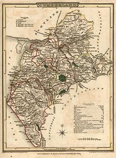
Map, hand coloured engraving, Cumberland, scale about 8
miles to 1 inch, by G Cole, engraved by J Roper, published
by Vernor, Hood and Sharpe, Poultry, London, 1807.
To accompany the Beauties of England and Wales. |
||

|
Cole and Roper 1805 | |
| map feature:- | plain cartouche & compass rose & up is N & scale line & lat and long scales & table of symbols & sea plain (?) & coast form lines & rivers & lakes & relief & hill hachuring & forests & parks & county & wards & table of wards & settlements & roads | |
| inscription:- |
printed title cartouche, top centre
CUMBERLAND |
|
| inscription:- |
printed bottom, left, centre, right
Engraved by J. Roper from a drawing by G. Cole. / London : Published by Vernor, Hood & Sharpe, Poultry. March 1st. 1807. / to accompany the Beauties of England & Wales. |
|
| inscription:- |
printed with scale line
SCALE / Miles |
|
| scale line:- | 10 miles = 31.8 mm | |
| scale:- | 1 to 510000 ? (1 to 506083 from scale line) | |
| wxh, map:- | 176x234mm | |