 Cole and Roper 1805

|

|
|
|
item:- Dove Cottage : 2009.81.6 image:- © see bottom of page |
click to enlarge |
|
|
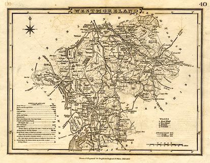
Map, uncoloured engraving, Westmoreland ie Westmorland,
scale about 6 miles to 1 inch, by G Cole, engraved by J
Roper, published by Vernor, Hood and Sharpe, Poultry,
London, 1807.
Included in Dugdale's England and Wales Delineated. |
||

|
Cole and Roper 1805 | |
| map feature:- | plain cartouche & compass rose & up is N & scale line & lat and long scales & table of symbols & sea plain (?) & coast form lines & rivers & lakes & relief & hill hachuring & parks & county & wards (hundreds) & settlements & roads | |
| inscription:- |
printed title cartouche, top centre
WESTMORELAND |
|
| inscription:- |
printed bottom centre
Drawn & Engraved for Dugdale's England and Wales Delineated. |
|
| scale line:- | 10 miles = 42.9 mm | |
| scale:- | 1 to 380000 ? (1 to 375138 from scale line) | |
| wxh, sheet:- | 27x22cm | |
| wxh, map:- | 233x174mm | |