 New Map of England and Wales

|

|
|
|
map type:- Cary 1794 |
 |
|
|
Maps, Westmorland, Cumberland, Lancashire etc on a New
Map of England and Wales, scale about 5 miles to 1 inch, by
John Cary, 181 Strand, London, 1794; published 1794-1824 and
later.
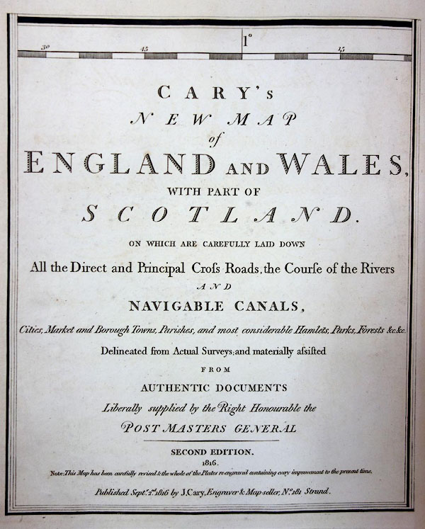
Published in 'CARY'S NEW MAP of ENGLAND AND WALES, WITH PART OF SCOTLAND. ON WHICH ARE CAREFULLY LAID DOWN All the Direct and Principal Cross Roads, the Course of the Rivers AND NAVIGABLE CANALS, Cities, Market and Borough Towns, Parishes, and most considerable Hamlets, Parks, Forests, &c. &c. Delineated from Actual Surveys: and materially assisted FROM AUTHENTIC DOCUMENTS liberally supplied by the Right Honourable the POST MASTER GENERAL / LONDON: Published June 11th. 1794 by J. Cary. Engraver & Map-seller, No.181 Strand. The map was published in 81 sections. Plate 58 includes parts of Lancashire, and most of Westmorland and Cumberland; the sheet number is printed top centre in an index diagram giving the sheet numbers to the north, east, south, and west. The sheets of the whole map which are relevant to Cumbria are:- 49 - parts of Westmorland, Cumberland, Lancashire North of the Sands. 50 - parts of Westmorland. 57 - parts of Cumberland. 58 - parts of Westmorland, and Cumberland. 59 - parts of Westmorland, Cumberland, and Yorkshire, Sedbergh area. 67 - parts of Cumberland. 68 - parts of Cumberland. Published again as 'SECOND EDITION. 1816. Note: This Map has been carefully revised & the whole of the Plates re-engraved containing every improvement to the present time. Published Septr. 2nd. 1816 by J. Cary, Engraver & Map-seller, No.181 Strand.' Published again as a third edition, 'SECOND EDITION. Corrected to 1824. Note: This Map has been carefully revised & the whole of the Plates re-engraved containing every improvement to the present time. Published May 1st. 1824, by G. & J. Cary, Engraver & Map-seller, No.86 St. James's Street.' The 1824 example, seen at the BL, has date 1816 in its lower border. Published again with railways added, later in the 19th century. |
||
|
(map example JandMN (13))
|
||
| map feature:- | up is N & sea shaded & coast shaded & rivers & lakes & relief & hill hachuring & parks & county & settlements & roads & road distances & railways | |
| inscription:- |
printed bottom
Published by J. Cary, June 1st. 1794. |
|
| scale line (printed on its own sheet in the atlas):- | 30 miles = 152.1 mm | |
| scale:- | 1 to 320000 ? (1 to 317425 from scale line) | |
| wxh, map:- | 206x258mm | |
| inscription:- |
printed page 2, sheet 71, 2nd edn, 1824
To / The Right Honourable / PHILIP / Earl of Chesterfield and Baron Stanhope / AND / Thomas Baron walsingham, / Post Masters General, / AND / Members of his MAJESTY'S most honourable / Privy Council / This MAP of ENGLAND & WALES is with / Their Lordship's Permission humbly dedicated / By their Lordship's most obedient / And obliged Servant / JOHN CARY |
|

|
||
|
||
| references:- |
Cary, John: 1794: Cary's New Map of England and Wales: Cary,
John (London):: BL Maps C.25.c.10. Cary, John: 1816 (2nd edn): Cary's New Map of England and Wales: Cary, John (London) Cary, John: 1824 (2nd edn): Cary's New Map of England and Wales: Cary, G and J (London):: BL Maps 6.c.4 |
|
| sources:- |
JandMN Collection Armitt Library British Library Kendal Library Maps British Postal Museum and Archive |
|
| items seen (illustrated items in bold):- | ||

|
Armitt Library : ALMC2008.14.56 -- map (plate 58) -- New Map of England and Wales | |
|
|
British Postal Museum and Archive (7) -- map -- Cary's New Map of England and Wales with Part of Scotland | |
|
|
JandMN (13) -- map (plate 58) -- New Map of England and Wales -- Cary's New Map of England and Wales | |
|
|
JandMN (14) -- map (plate 58) -- New Map of England and Wales -- Cary's New Map of England and Wales | |
|
|
JandMN (138) -- map (plate 59) -- New Map of England and Wales -- Cary's New Map of England and Wales | |
|
|
JandMN (223) -- map (plate 53) -- New Map of England and Wales -- Cary's New Map of England and Wales | |
|
|
JandMN (224) -- map (plate 54) -- New Map of England and Wales -- Cary's New Map of England and Wales | |
|
|
JandMN (274) -- map (plate 67) -- New Map of England and Wales -- Cary's New Map of England and Wales | |
|
|
Kendal Library : Map 129 -- map (plate 59) -- New Map of England and Wales -- Cary's New Map of England and Wales | |
|
|
Kendal Library : Map 146 -- map (plate 58) -- New Map of England and Wales -- Cary's New Map of England and Wales | |