 Cary 1794

|

|
|
|
item:- Armitt Library : ALMC2008.14.56 image:- © see bottom of page |
click to enlarge |
|
|
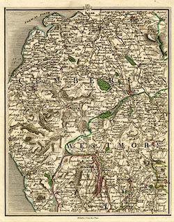
Map, hand coloured engaving, plate 58 of a New Map of
England and Wales, parts of Lancashire, and of Westmorland
and Cumberland, scale about 5 miles to 1 inch, by John Cary,
181 Strand, London, 1794.
At the top of the map is a guide diagram to adjacent pages, 67 to the North, 57 West, 59 East, 49 South. |
||

|
Cary 1794 | |
| map feature:- | up is N & sea shaded & coast shaded & rivers & lakes & relief & hill hachuring & parks & county & settlements & roads & road distances | |
| inscription:- |
printed bottom
Published by J. Cary, June 1st. 1794. |
|
| scale line (printed on its own sheet in the atlas):- | 30 miles = 152.1 mm | |
| scale:- | 1 to 320000 ? (1 to 317425 from scale line) | |
| wxh, map:- | 207x2258mm | |