 Cary 1794

|

|
|
|
item:- JandMN (14) image:- © see bottom of page |
click to enlarge |
|
|
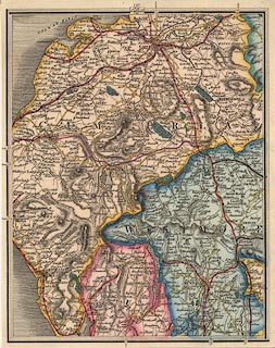
Map, hand coloured engaving, plate 58 of a New Map of
England and Wales, parts of Lancashire, and of Westmorland
and Cumberland, scale about 5 miles to 1 inch, by John Cary,
181 Strand, London, 1794, later edition, mid 19th century.
At the top of the map is a guide diagram to adjacent pages, 67 to the North, 57 West, 59 East, 49 South. Railways have been added to the original map, and the colouring has the boldness expected of the later period. |
||

|
Cary 1794 | |
| map feature:- | up is N & sea shaded & coast shaded & rivers & lakes & relief & hill hachuring & parks & county & settlements & roads & road distances | |
| scale:- | 1 to 320000 ? (1 to 317425 from scale line) | |
| wxh, map:- | 206x258mm | |