 Cary 1790

|

|
|
|
map type:- Cary 1790 |
|
|
|
Maps, Westmoreland, scale about 11.5 miles to 1 inch,
Cumberland, scale about 15 miles to 1 inch, Lancashire,
scale about 18 miles to 1 inch, etc, by John Cary, 181
Strand, London, 1790; published 1790-1828.
Published in 'CARY'S TRAVELLER'S COMPANION, OR, A Delineation of the Turnpike ROADS OF England AND Wales; shewing the immediate Route to every MARKET and BOROUGH TOWN throughout the KINGDOM, Laid down from the best Authorities, ON A NEW SET OF COUNTY MAPS. To which is added, An Alphabetical List of all the Market Towns, with the Days on which they are held. / LONDON. Printed for John Cary, Engraver, and Map seller, STRAND. 1819.' The atlas has a title page, contents list, map of England and Wales, and county maps; at the end is a list of markets; the atlas size is 4 x 6 1/4 ins. A preface page has a table of symbols for the maps. Published in many editions, eg 1790, 1791, 1806, 1810, 1812, 1814, 1817, 1819, 1821, 1822, 1824, and 1828. |
||
|
(map example JandMN (44_1))
|
||
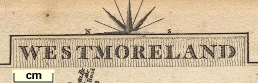
| map feature:- | title cartouche & plain cartouche & compass rose (half) & up is E & scale line & coast form lines & rivers & bridges & parks & county & settlements & roads & road distances & canals | |
| inscription:- |
printed top
By J. Cary / WESTMORELAND / Engraver. |
|
| inscription:- |
printed bottom
London Published Sepr. 1, 1792 by J. Cary Engraver No.181 Strand |
|
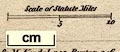
| scale:- | 1 to 730000 ? (1 to 728210 from scale line assuming a statute mile) | |
| scale line:- | 10 miles = 22.1 mm | |
| wxh, sheet:- | 10.5x16cm | |
| wxh, map (include cartouche, exclude bits overlapping map border):- | 93x132 mm | |
| inscription:- |
[London. Printed for G. & J. Cary, Engraver. No.86, St. James's Street, 1822.] 1822 edition |
|
| inscription:- |
[J. Cary HAMPSHIRE Engraver] |
|
| inscription:- |
[London. Published Sepr 1, 1789 by J. Cary, Engraver No.188 Strand] |
|
| inscription:- |
[London. Published Sepr 1, 1792 by J. Cary, Engraver, No.181 Strand.] 1791 edition |
|
| inscription:- |
[London. Printed for G. & J. Cary, Engraver. No.86, St. James's Street, 1822.] 1822 edition |
|
|
||
|
||
| references:- |
Cary, John: 1789 & 1790 & 1791 & 1806 & 1810 & 1812 & 1814 &
1817 & 1819 & 1821 & 1822 & 1824 & 1828: Cary's Traveller's
Companion & Delineation of the Turnpike Roads of England and
Wales: (London) |
|
| sources:- |
Chubb 1927 (CCLXXIII) JandMN Collection Wordsworth Trust Collection Armitt Library private collection |
|
| items seen (illustrated items in bold):- | ||

|
Armitt Library : ALMC2008.14.57 -- road map -- Westmoreland | |
|
|
Dove Cottage : 2007.38.48 -- road map -- Westmoreland -- Wiltshire | |
|
|
Dove Cottage : 2007.38.49 -- road map -- Westmoreland -- Wiltshire | |
|
|
Dove Cottage : 2007.38.50 -- road map -- Westmoreland | |
|
|
JandMN (44) -- road map -- Westmoreland | |
|
|
JandMN (416) -- road map -- Durham | |
|
|
JandMN (417) -- road map -- Northumberland | |
|
|
JandMN (418) -- road map -- Lancashire -- Leicestershire | |
|
|
JandMN (419) -- road map -- Cumberland -- Derbyshire | |
|
|
JandMN (420) -- title page -- Cary's Traveller's Companion | |
|
|
private collection (251) -- road map -- Lancashire | |