 Cary 1790

|

|
|
|
item:- Dove Cottage : 2007.38.48 image:- © see bottom of page |
click to enlarge |
|
|
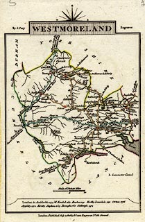
Road map, hand coloured engraving, Westmoreland ie
Westmorland, scale about 11.5 miles to 1 inch, by John Cary,
181 Strand, London, 1790, edn 1806.
From Cary's Traveller's Companion, an atlas of turnpike routes, published 1790 onwards. The reverse side has the corresponding map for Wiltshire. |
||

|
Cary 1790 | |
| map feature:- | compass rose cartouche & compass rose & up is E & scale line & coast form lines & rivers & lakes & parks & county & settlements & roads & road distances & distances from London & canals | |
| inscription:- |
printed title cartouche, at top
WESTMORELAND |
|
| inscription:- |
printed either side of the title cartouche
By J. Cary. / Engraver. |
|
| inscription:- |
printed bottom
London Published July 1. 1806 by J. Cary Engraver No.181 Strand |
|
| scale line:- | 10 miles = 21.7 mm | |
| scale:- | 1 to 740000 ? (1 to 741633 from scale line) | |
| wxh, sheet:- | 12x18.5cm | |
| wxh, map:- | 93x131mm | |