 Cary 1790

|

|
|
|
item:- JandMN (416) image:- © see bottom of page |
click to enlarge |
|
|
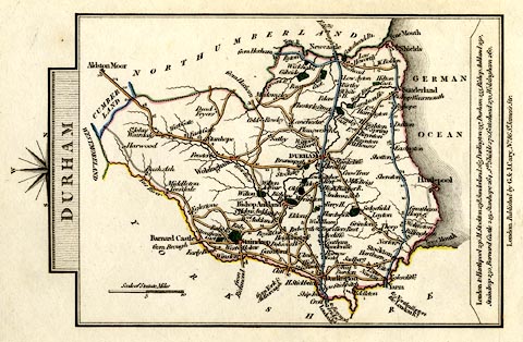
Road map, hand coloured engraving, Durham, scale about
11.5 miles to 1 inch, by John Cary, 181 Strand, 1790, edn
published by G and J Cary, 86 St James's Street, London,
1824.
Included in Cary's Traveller's Companion, an atlas of turnpike routes, from 1790 onwards. |
||

|
Cary 1790 | |
| map feature:- | compass rose cartouche & compass rose & up is W & scale line & coast form lines & rivers & parks & county & settlements & roads & turnpike roads & road distances & distances from London | |
| inscription:- |
printed title cartouche, at top
DURHAM |
|
| inscription:- |
printed bottom
London. Published by G. & J. Cary No.86 St. James's Str. |
|
| inscription:- |
printed above scale line
Scale of Statute Miles |
|
| scale line:- | 10 miles = 21.9 mm | |
| wxh, sheet:- | 11.5x18cm | |
| wxh, map:- | 133x92mm | |
| scale:- | 1 to 730000 ? (1 to 734860 from scale line) | |