 Cary 1790

|

|
|
|
item:- JandMN (419) image:- © see bottom of page |
click to enlarge |
|
|
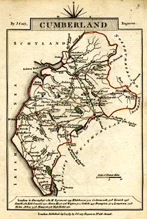
Road map, hand coloured engraving, Cumberland, scale
about 15 miles to 1 inch, by John Cary, 181 Strand, London,
1790, edn 1789.
The reverse is Derbyshire. Included in Cary's Traveller's Companion, an atlas of turnpike routes, from 1790 onwards. |
||

|
Cary 1790 | |
| map feature:- | compass rose cartouche & compass rose & up is N & scale line & coast form lines & rivers & lakes & parks & county & settlements & roads & turnpike roads & road distances & distances from London | |
| inscription:- |
printed title cartouche, at top
CUMBERLAND |
|
| inscription:- |
printed either side of the title cartouche
By J. Cary. / Engraver. |
|
| inscription:- |
printed bottom
London. Published Sepr. 1. 1789 by J. Cary Engraver No.181 Strand |
|
| inscription:- |
printed above scale line
Scale of Statute Miles |
|
| scale line:- | 10 miles = 16.9 mm | |
| inscription:- |
printed title cartouche, at top
DERBYSHIRE |
|
| wxh, sheet:- | 10.5x16cm | |
| wxh, map:- | 93x132mm | |
| scale:- | 1 to 950000 ? (1 to 952275 from scale line) | |