 Smith 1824

|

|
|
|
item:- Carlisle Library : Map 58 image:- © Carlisle Library |
click to enlarge |
|
|
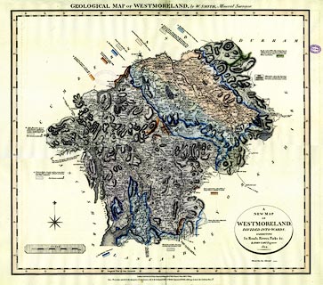
Map, hand coloured engraving, Geological Map of
Westmoreland, scale about 2.5 miles to 1 inch, by William
Smith, coloured on a map by John Cary, published by John
Cary, 86 St James's Street, London, 1824.
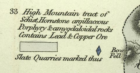
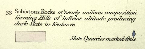
The geological areas are explained by colour patches around the map boundaries accompanied by descriptive text. |
||

|
Smith 1824 | |
| map feature:- | up is N & oval cartouche & coast form lines & rivers & lakes & relief & hill hachuring & woods & forests & parks & county & settlements & roads & canals & geology | |
| inscription:- |
printed top
GEOLOGICAL MAP of WESTMORELAND, by W. SMITH, Mineral Surveyor. |
|
| inscription:- |
printed oval cartouche, lower right
A NEW MAP / OF / WESTMORELAND, / DIVIDED INTO WARDS, / EXHIBITING / Its Road, Rivers, Parks &c. / By JOHN CARY, Engraver. / 1824 |
|
| inscription:- |
printed bottom
London Published by J. Cary Engraver & Map-seller No.86 St. James's Street, March 1st. 1824. / Note, the numbers attached to the description of each stratum, refer to the Geological Table of British Organized Fossils, which may be had of the Publisher; price 1s. 6d. |
|
| inscription:- |
printed with scale line
SCALE / Miles |
|
| scale line:- | 8 miles = 82.3 mm | |
| wxh, map:- | 538x481mm | |
| scale:- | 1 to 160000 ? (1 to 156437 from scale line, assuming a statute mile) | |
|
images:- © Carlisle Library |
|
|
|
||
|
||
|
||
|
|
notes | |
|
|
notes | |