 Old Cumbria Gazetteer
 |
 |
|
||||||||||||||||||||||||||||||||||||||
| Westmorland | ||||||||||||||||||||||||||||||||||||||||
| Westmoreland | ||||||||||||||||||||||||||||||||||||||||
| county:- | Cumbria | |||||||||||||||||||||||||||||||||||||||
| locality type:- | county, old | |||||||||||||||||||||||||||||||||||||||
|
|
||||||||||||||||||||||||||||||||||||||||
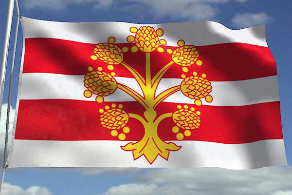 CCR43.jpg New flag. courtesy of Jason Saber |
||||||||||||||||||||||||||||||||||||||||
|
|
||||||||||||||||||||||||||||||||||||||||
| evidence:- | descriptive text:- Monmouth c1136 |
|||||||||||||||||||||||||||||||||||||||
| source data:- | Book, The History of the Kings of Britain, by Geoffrey of
Monmouth, about 1136, translated by Lewis Thorpe, published by
Penguin Books, 1966. |
|||||||||||||||||||||||||||||||||||||||
| source data:- | Courtesy of Penguin Books (licence PM6935) "... Octavius, Duke of the Gewissei, led a revolt against a certain proconsul in whose hands, as a Roman dignitary, the government of the island had been left. ... Octavius seized the royal throne. This event was announced to Constantine and he sent Helen's uncle Trahern with three legions to restore the island to Roman sovereignty. ... King Octavius .... reassembled his men in companies, followed Trahern, and fought him in the province called Westmorland. This time Octavius was defeated, and fled. When Trahern realized that victory was his, he pursued Octavius, and gave him no respite until he had wrested from him his cities and his crown." |
|||||||||||||||||||||||||||||||||||||||
|
|
||||||||||||||||||||||||||||||||||||||||
| evidence:- | descriptive text:- Monmouth c1136 item:- stone; monument |
|||||||||||||||||||||||||||||||||||||||
| source data:- | Book, The History of the Kings of Britain, by Geoffrey of
Monmouth, about 1136, translated by Lewis Thorpe, published by
Penguin Books, 1966. Courtesy of Penguin Books (see licence for website, 2007-2012, from Penguin Group PM6935) "Marius, the son of Arvirargus, succeeded ... in the kingship. He was a man of great prudence and wisdom. A little later on in his reign a certain King of the Picts called Sodric came from Scythia with a large fleet and landed in the northern part of Britain which is called Albany. He began to ravage Marius' lands. Marius thereupon collected his men together and marched to meet Sodric. He fought a number of battles against him and finally killed him and won a great victory. In token of his triumph Marius set up a stone in the district, which was afterwards called Westmorland after him. The inscription carved on it records his memory down to this very day. ..." |
|||||||||||||||||||||||||||||||||||||||
|
|
||||||||||||||||||||||||||||||||||||||||
| evidence:- | old map:- Lloyd 1573 placename:- Westmerland |
|||||||||||||||||||||||||||||||||||||||
| source data:- | Map, hand coloured copper plate engraving, Angliae Regni,
Kingdom of England, with Wales, scale about 24 miles to 1 inch, authored by Humphrey
Lloyd, Denbigh, Clwyd, drawn and engraved
by Abraham Ortelius, Netherlands, 1573. click to enlarge click to enlargeLld1Cm.jpg "Westmerland" item:- Hampshire Museums : FA1998.69 Image © see bottom of page |
|||||||||||||||||||||||||||||||||||||||
|
|
||||||||||||||||||||||||||||||||||||||||
| evidence:- | old map:- Saxton 1579 placename:- Westmorelandia |
|||||||||||||||||||||||||||||||||||||||
| source data:- | Map, Westmorlandiae et Cumberlandiae Comitatus ie Counties of
Westmorland and Cumberland, scale about 5 miles to 1 inch, by
Christopher Saxton, London, engraved by Augustinus Ryther, 1576
and presumably available from that date, published with other
county maps in an atlas 1579; published 1579-1645. "Westmorelandia" |
|||||||||||||||||||||||||||||||||||||||
|
|
||||||||||||||||||||||||||||||||||||||||
| evidence:- | old map:- Keer 1605 placename:- Westmorland |
|||||||||||||||||||||||||||||||||||||||
| source data:- | Map, hand coloured engraving, Westmorland and Cumberland, scale
about 16 miles to 1 inch, probably by Pieter van den Keere, or
Peter Keer, about 1605 edition perhaps 1676. click to enlarge click to enlargeKER8.jpg "Westmorland" county item:- Dove Cottage : 2007.38.110 Image © see bottom of page |
|||||||||||||||||||||||||||||||||||||||
|
|
||||||||||||||||||||||||||||||||||||||||
| evidence:- | descriptive text:- Keer 1605 (edn 1620) placename:- Westmorland placename:- Westmaria placename:- Westmorlandia placename:- Westmoria item:- placename, Westmorland; Westmorland, extent |
|||||||||||||||||||||||||||||||||||||||
| source data:- | Map, Westmorlandia et Comberlandia, ie Westmorland and
Cumberland now Cumbria, scale about 16 miles to 1 inch, probably
by Pieter van den Keere, or Peter Keer, about 1605, published
about 1605 to 1676. goto source goto sourcefirst page:- "WESTMORLAND." "CHAPTER XL." "WESTMORLAND, by some late Latine Writers is called Westmaria, and Westmorlandia, by some later Westmoria, and in our English Tongue Westmorland. It came to be thus named in our language by the situation, which in every part is so plenteously full of Moores and high hils, reaching one to another, that Westmorland (with us) is nothing else but a Westerne moorish Country. Having on the West and North-side Cumberland, on the South-part Lanca-shire, on the East-side Yorkeshire, and the Bishopricke of Durham." "(2) The length thereof extended from Burton in her South, to Kirkland in her North-part is 30. miles: the broadest part from East to West, is from the River Eden to Dunbal rase-stones, containing 24 miles, the whole circumference about 112. miles." "(3) The forme thereof is somewhat long and narrow: the Aire sharpe and piercing, purging it selfe from the trouble of grosse foggy mists and vapours, by reason of which the people of this Province are not acquainted with strange diseases or imperfections of body, but live long, and are healthfull, and attaine to the number of many yeares." "(4) The Soile for the most part of it, is but barren, and can hardly be brought to any fruitfulnesse by the industry and painfull labour of the husbandman, being so full of infertile places, which the Northern Englishmen call Moores: yet the more Southerly part is not reported to be so sterile, but more fruitfull in the vallies, ..." goto sourcesecond page "(5) The ancient Inhabitants of this Country were the Brigantes, mentioned in the severall Counties of Yorke, Lancaster, and Cumberland." "(6) It is not commended either for plentie of Corne or Cattle, being neither stored with arable grounds to bring forth the one, nor pasturage to breed up the other: the principall profit that the people of this Province raise unto themselves, is by cloathing." goto sourcefourth page "..." "(11) This Province is traded with foure Market-Townes, fortified with the strength of seven Castles, and hath 26. Parishes in it for the celebration of Divine Service." |
|||||||||||||||||||||||||||||||||||||||
|
|
||||||||||||||||||||||||||||||||||||||||
| evidence:- | old map:- Speed 1611 (Cum/EW) placename:- Westmorland |
|||||||||||||||||||||||||||||||||||||||
| source data:- | Map, hand coloured engraving, Kingdome of Great Britaine and
Ireland, scale about 36 miles to 1 inch, by John Speed, about
1610-11, published by Thomas Bassett, Fleet Street and Richard
Chiswell, St Paul's Churchyard, London, 1676? click to enlarge click to enlargeSPD6Cm.jpg "WESTMORLAND" county item:- private collection : 85 Image © see bottom of page |
|||||||||||||||||||||||||||||||||||||||
|
|
||||||||||||||||||||||||||||||||||||||||
| evidence:- | poem:- Drayton 1612/1622 text placename:- Westmerland |
|||||||||||||||||||||||||||||||||||||||
| source data:- | Poem, Poly Olbion, by Michael Drayton, published by published by
John Marriott, John Grismand and Thomas Dewe, and others?
London, part 1 1612, part 2 1622. goto source Preceding this page is the map for Westmorland and Cumberland. page 161; Westmorland and Cumberland:- "The thirtieth Song." "THE ARGUMENT." "Of Westmerland the Muse now sings, And fetching Eden from her Springs, Sets her along, and Kendall then Surveying, beareth back agen; And climbing Skidows loftie Hill, By many a River, many a Rill, To Cumberland, where in her way, Shee Copland calls, and doth display Her Beauties, backe to Eden goes, Whose Floods, and Fall shee aptly showes." |
|||||||||||||||||||||||||||||||||||||||
|
|
||||||||||||||||||||||||||||||||||||||||
| evidence:- | table of distances:- Simons 1635 placename:- Westmerland |
|||||||||||||||||||||||||||||||||||||||
| source data:- | Table of distances, uncoloured engraving, Westmerland ie
Westmorland, with a thumbnail map, scale about 42 miles to 1
inch, by Mathew Simons, published in A Direction for the English
Traviller, 1635.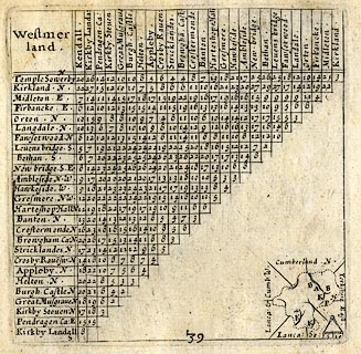 click to enlarge click to enlargeSIM3.jpg "Westmerland" in title cartouche; adjacent counties given on thumbnail map "Lanca: &Cumb: W / Cumberland N / Yorkshire East / Lanca: So:" item:- private collection : 50.39 Image © see bottom of page |
|||||||||||||||||||||||||||||||||||||||
|
|
||||||||||||||||||||||||||||||||||||||||
| evidence:- | old map:- Jenner 1643 placename:- Westmerland |
|||||||||||||||||||||||||||||||||||||||
| source data:- | Table of distances, with map, hand coloured engraving,
Westmerland ie Westmorland, scale about 16 miles to 1 inch,
engraved by Jacob van Langeren, published by Thomas Jenner,
Cornhill, London, 1643.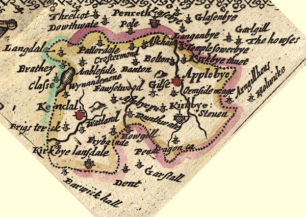 JEN3Sq.jpg "Westmerland" item:- private collection : 52.Wmd Image © see bottom of page |
|||||||||||||||||||||||||||||||||||||||
|
|
||||||||||||||||||||||||||||||||||||||||
| evidence:- | old map:- Sanson 1679 placename:- Westmorland |
|||||||||||||||||||||||||||||||||||||||
| source data:- | Map, hand coloured engraving, Ancien Royaume de Northumberland
aujourdhuy Provinces de Nort, ie the Ancient Kingdom of
Northumberland or the Northern Provinces, scale about 9.5 miles
to 1 inch, by Nicholas Sanson, Paris, France, 1679. click to enlarge click to enlargeSAN2Cm.jpg "WESTMORLAND" county; included in the 'Royaume de Northumberland' item:- Dove Cottage : 2007.38.15 Image © see bottom of page |
|||||||||||||||||||||||||||||||||||||||
|
|
||||||||||||||||||||||||||||||||||||||||
| evidence:- | old map:- Seller 1694 (Wmd) placename:- Westmorland County |
|||||||||||||||||||||||||||||||||||||||
| source data:- | Map, hand coloured engraving, Westmorland, scale about 8 miles
to 1 inch, by John Seller, 1694. click to enlarge click to enlargeSEL7.jpg "WESTMORLAND COUNTY" title in wreath cartouche item:- Dove Cottage : 2007.38.87 Image © see bottom of page |
|||||||||||||||||||||||||||||||||||||||
|
|
||||||||||||||||||||||||||||||||||||||||
| evidence:- | old map:- Morden 1695 (EW) placename:- Westmoreland |
|||||||||||||||||||||||||||||||||||||||
| source data:- | Map, hand coloured engraving, England, including Wales, scale
about 27 miles to 1 inch, by Robert Morden, published by Abel
Swale Awnsham and John Churchil, London, about 1695. click to enlarge click to enlargeMRD3Cm.jpg "WESTMORELAND" county item:- JandMN : 339 Image © see bottom of page |
|||||||||||||||||||||||||||||||||||||||
|
|
||||||||||||||||||||||||||||||||||||||||
| evidence:- | descriptive text:- Fiennes 1698 |
|||||||||||||||||||||||||||||||||||||||
| source data:- | Travel book, manuscript record of Journeys through England
including parts of the Lake District, by Celia Fiennes, 1698. "... hereabout [Pooley Bridge?] we leave those desart and barren rocky hills, not that they are limitted to Westmorland only, for had I gone farther to the left hand on into Cumberland I should have found more such and they tell me farr worse for height and stony-nesse about White haven side and Cockermouth, so that tho' both the County's have very good land and fruitfull, so they equally partake of the bad, tho' indeed Westmorland takes its name from its abounding in moorish ground yet Cumberland has its share, and more of the hilly stony part; indeed I did observe those grounds were usually neighbours to each other, the rocks abounding in springs which distilling it self on lower ground if of a spungy soile made it marshy or lakes, and in many places very fruitfull in summer graine and grasse, but the northerly winds blow cold so long on them that they never attempt sowing their land with wheate or rhye." |
|||||||||||||||||||||||||||||||||||||||
|
|
||||||||||||||||||||||||||||||||||||||||
| evidence:- | old map:- Bowen 1720 (plate 271) placename:- Westmorland item:- climate; soil; sheep; corn; grass |
|||||||||||||||||||||||||||||||||||||||
| source data:- | Map, county map, pl.271, A Map of Westmorland, published by
Emanuel Bowen, St Katherines, London, 1720.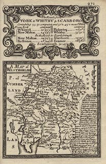 click to enlarge click to enlargeB271.jpg Plate 271 has the county map and descriptive text of:- "The County of WESTMORLAND is 110 M. in Circumference contains abt. 510000 Acres, 5 Wards, 8 Mt. & 2 Borough Towns 26 Pars. & about 6500 Houses. The Air is very sharp & cold & not subject to Foggs but healthy & agreable with strong Constitutions; insomuch that it hardens them against Diseases. The Soil is not very good but Mountainous & Moory, having several very high Hills. Ye Northern Parts are best. Its Comod~ & Manufacture is Cloth, & tho' this County is but barren on ye Hills yet there are good store of Sheep & ye Valleys are fruitfull in Corn &produce much Grass near ye Rivers. It pays in ye [Q|2] Aid L1522-11-10" item:- private collection : 1.271 Image © see bottom of page |
|||||||||||||||||||||||||||||||||||||||
|
|
||||||||||||||||||||||||||||||||||||||||
| evidence:- | descriptive text:- Defoe 1724-26 placename:- Westmoreland |
|||||||||||||||||||||||||||||||||||||||
| source data:- | Tour through England and Wales, by Daniel Defoe, published in
parts, London, 1724-26. "Here we entred Westmoreland, a county eminent only for being the wildest, most barren and frightful of any that I have passed over in England, or even in Wales it self; the west side, which borders on Cumberland, is indeed bounded by a chain of almost unpassable mountains, which, in the language of the country, are called Fells, and these are called Fourness Fells, from the famous promontory bearing that name, and an abbey built also in antient times, and called Fourness." "But 'tis of no advantage to represent horror, as the character of a country, in the middle of all the frightful appearances to the right and left; yet here are some very pleasant, populous and manufacturing towns, and consequently populous." "..." "When we entred at the south part of this county, I began indeed to think of Merionethshire, and the mountains of Snowden in North Wales, seeing nothing round me, in many places, but unpassable hills, whose tops, covered with snow, seemed to tell us all the pleasant part of England was at an end. ..." |
|||||||||||||||||||||||||||||||||||||||
|
|
||||||||||||||||||||||||||||||||||||||||
| evidence:- | old map:- Badeslade 1742 placename:- Westmorland |
|||||||||||||||||||||||||||||||||||||||
| source data:- | Map, uncoloured engraving, A Map of Westmorland North from
London, scale about 10 miles to 1 inch, with descriptive text,
by Thomas Badeslade, London, engraved and published by William
Henry Toms, Union Court, Holborn, London, 1742. click to enlarge click to enlargeBD12.jpg "WESTMORLAND" county "Westmorland sends 4 members to Parliament, containing one Borough, 8 Market Towns, and 26 large Parishes." "..." "The W. side of this County is divided from Cumberland by Winander Meer, & the River Winster. The N.W. Boundary is the River Eimot, which receives the Loder, and at last unites with the Eden. The S. part of the County is divided into 2 by the Can or Ken, which gives name to Kendale & the Lone or Lune after having received the River Burrow is the Boundary to Yorkshire, then passes by Kirby Lonsdale into Lancashire. The River Eden rises in the E. part of the County, receives first the little River Belo, afterwards Blenkern, &at the N. point unites with Eimot, and flows into Cumberland." item:- Dove Cottage : 2007.38.62 Image © see bottom of page |
|||||||||||||||||||||||||||||||||||||||
|
|
||||||||||||||||||||||||||||||||||||||||
| evidence:- | descriptive text:- Simpson 1746 placename:- Westmoreland placename:- Applebyshire placename:- County of Appleby placename:- Westmorland item:- coal; wood; sheep; copper ore; climate; barony; wards; hundreds; parishes |
|||||||||||||||||||||||||||||||||||||||
| source data:- | Atlas, three volumes of maps and descriptive text published as
'The Agreeable Historian, or the Compleat English Traveller
...', by Samuel Simpson, 1746. goto source Page 1019:- "WESTMORELAND." "THIS is an Inland County, which has Lancashire on the South and South west; Cumberland on the West and North-west; and Yorkshire and the Bishoprick of Durham on the East and North-east. 'Tis commonly reckoned 30 Miles in Length, but not above 24 in Breadth, and about 120 in Compass. containing 510000 Acres of Land. Mr. Templeman makes it 36 Miles in Length, and 34 in Breadth, and gives it an Area of 633 square Miles." "'Tis divided into the Barony of Westmoreland, which is a large, open, champain County, belonging to the Diocese of Carlisle, twenty Miles long, and fourteen broad; and the Barony of Kendal, which is full of Mountains, and belongs to the Diocese of Chester. Both these are subdivided into two Wards, each of which contains thirty-two Parishes, wherein are many Chapels of Ease, eight Market-towns, of which one only is a parliamentary Borough; and about 6600 Houses. In each of these Divisions are several Deaneries and Constablewicks, but no Hundreds, perhaps because anciently these Parts paid no Subsidies, being sufficiently charg'd in the Border-service against the Scots. The Gentlemens Houses in this County are large and strong, and generally built Castle-wise, for Defence of themselves, their Tenants, and their Goods, against the Scots Incursions, which before the Time of King James I. were very common." "The Barony, or Bottom (as 'tis also call'd from its low Situation) of Westmoreland, which is the northern Part, affords Plenty of arable Land, which bears good Store of Corn. The Barony of Kendale, or Candalia, which is the southern Part of the County, and so called from the River Can, which runs along the Valley, is pent up for [some]" goto sourcePage 1020:- "some Space in a narrow Compass between the River Lone on the East, and Winander mere on the West, and has some Rocks as well as Mountains, but is pretty fruitful in the Vallies, especially in the Meadows, near the Rivers; and its Mountains have good Pasture for Sheep, with Copper Ore in some Parts." "Its Air is sweet, healthful, and pleasant, but somewhat sharp in the mountainous Parts." goto sourcePage 1021:- "..." "Besides Pit-coal, this County abounds with other Fuel, there being Plenty of Wood upon the Mountains in the Barony of Kendal; and there are divers Forests in the Barony of Westmoreland, as Whinfield-Forest in the Peninsula between the Rivers Eimot and Eden; Martindale-Forest, which extends almost the whole Length of Ulleswater; Thornthwait Forest, Mallerstang, Milborn, and Melden-Forests; besides divers Parks, which are well stock'd with Wood in both Baronies." "This County gave formerly Title of Baron to the Family of Vipont, and afterwards of Earl, first to the Family of Nevil, and then to that of Fane, which now enjoys it. It sends only four Members to Parliament, viz. two for the County and two for [Appleby]" goto sourcePage 1022:- "... Brompton makes mention of Applebyshire, and 'tis supposed that it [Appleby] had once Sheriffs of its own, as most Cities had; or else that Westmoreland was called the County of Appleby or Applebyshire. ..." |
|||||||||||||||||||||||||||||||||||||||
| source data:- | Maps, Westmorland, scale about 8 miles to 1 inch, and
Cumberland? printed by R Walker, Fleet Lane, London, 1746. "WESTMORLAND" |
|||||||||||||||||||||||||||||||||||||||
|
|
||||||||||||||||||||||||||||||||||||||||
| evidence:- | descriptive text:- Bickham 1753-54 (Wmd) |
|||||||||||||||||||||||||||||||||||||||
| source data:- | Maps, A Map of Westmorland, 1753, and A Map of Cumberland, 1754,
by George Bickham, James Street, Bunhill Fields, London;
published 1750s-96. "WESTMORELAND." "Westmoreland is bounded on the North and West by Cumberland and a detach'd Part of Lancashire, on the South by Lancashire, and in the East by Yorkshire and a Bit of Durham. Principal Rivers are the Lone, the Kan, &the Eden. The Standing waters of Winander Mere, and Ulles-Lake are also famous in this County." "The sharp and clear Air is healthy to the Natives and robust Strangers. The hilly Soil is very barren, but the Vallies are tolerably fertile in Corn and Grass. In the Western Hills are Quantities of Copper-Ore, with some veins of Gold, but not worth the Expence of digging. Stockings are the chief Manufacture, but Coth, and Stuffs are also made at Kendal." "Members of Parliament are two for the County, and two for the Borough of Appleby." "..." |
|||||||||||||||||||||||||||||||||||||||
|
|
||||||||||||||||||||||||||||||||||||||||
| evidence:- | old text:- Gents Mag placename:- Westmoreland item:- map; New Map of England and Wales |
|||||||||||||||||||||||||||||||||||||||
| source data:- | Map, uncoloured engraving, New Map of England and Wales, scale
about 25 miles to 1 inch, by Thomas Jefferys, published in the
Gentleman's Magazine, London, 1757. goto source Gentleman's Magazine 1757 opp p.584 A New Map of England and Wales, by Thomas Jefferys, published in the Gentleman's Magazine, London, 1757. 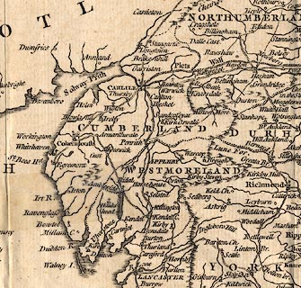 click to enlarge click to enlargeGNT8Cm.jpg "A New MAP of ENGLAND and WALES By Thos. Jefferys Geographer to his Royal Highness the Prince of WALES." item:- Hampshire Museums : B1999.518.1757.13.1 Image © see bottom of page |
|||||||||||||||||||||||||||||||||||||||
|
|
||||||||||||||||||||||||||||||||||||||||
| evidence:- | old text:- Morgan 1759 placename:- Westmorland |
|||||||||||||||||||||||||||||||||||||||
| source data:- | MG02q052.txt "WESTMORLAND." "THIS County is eminent only for being the wildest, most barren, and frightful, of any in England or Wales, though very healthful, since people live here to a very great age. In cities and great towns, scarce one third part that are born survive the age of two years; but in this country not above one in thirteen or fourteen dies within that period. But horrid as this country is in general, it abounds" MG02q053.txt "with numberless natural and romantic beauties." |
|||||||||||||||||||||||||||||||||||||||
|
|
||||||||||||||||||||||||||||||||||||||||
| evidence:- | descriptive text:- West 1778 (11th edn 1821) placename:- Westmorland |
|||||||||||||||||||||||||||||||||||||||
| source data:- | Guide book, A Guide to the Lakes, by Thomas West, published by
William Pennington, Kendal, Cumbria once Westmorland, and in
London, 1778 to 1821. goto source Addendum; Mr Gray's Journal, 1769 Page 210:- "..." "Oct. 8. I left Keswick, and took the Ambleside road, ..." "... soon after a beck near Dunmail-raise, where I entered Westmorland a second time: ..." |
|||||||||||||||||||||||||||||||||||||||
|
|
||||||||||||||||||||||||||||||||||||||||
| evidence:- | old text:- Clarke 1787 |
|||||||||||||||||||||||||||||||||||||||
| source data:- | Guide book, A Survey of the Lakes of Cumberland, Westmorland,
and Lancashire, written and published by James Clarke, Penrith,
Cumberland, and in London etc, 1787; published 1787-93. goto source Page 8:- "..." "Westmorland contains only one borough, namely Appleby, and sends four mem-" goto sourcePage 9:- "[mem]bers to Parliament. It is very like Cumberland in its soil and climate, and similarity of manners is every where to be found in both. Dr Falconer, in a learned and elegant paper, published in the Memoirs of the Literary Society of Manchester, has proved almost to demonstration, that the scenery of a country has the greatest share in forming the manners of its inhabitants: but to this I must add another source equally powerful, the necessities of situation." "The contemplation of barren heaths, bleak, rocky mountains, and almost impassable swamps and mosses, will naturally fill the mind with gloomy and uncomfortable ideas; but when the inhabitant has his daily sustenance to collect from these dreary wilds, he will alternately starve and gluttonize. If he is one day pinched with hunger, he will, if the next affords him a prey, fall to with the voracity of a wolf. Can we then wonder, that people so situated should have frequent quarrels with their neighbours? Can we wonder that they should, by every species of cruelty, endeavour to terrify their neighbours from attacking them, where we must be sensible that they have only the dreadful alternative to massacre their invaders, or perish by hunger? When necessity has thus begun the practice of cruelty, a spirit of revenge keeps it alive, till custom rivets it too fast to be easily removed." "In every country where this is not the case, a spirit of humanity in general keeps time with martial ardour. The vanquished yielding enemy is considered as not only entitled to mercy, but protection: the valour he has that day shewn, though at the expence of the noblest blood of the victors, increases the respect shewn him; and no one ever thinks of revenging at that time the death of a father, a son, or a brother. The Israelites were perhaps the only civilized nation that ever massacred a vanquished enemy in cool blood; nor were they contented with death alone, for they tortured them in the most cruel manner; "they hewed them to pieces with axes, and tore them with harrows." It is true, they pretended a divine mandate for this; but what age has not produced some crafty, designing priest, of art and impudence sufficient to gloss over the blackest crimes! The situation of the countries I am here describing is such, that they are extremely beautiful in Summer, and equally cold, bleak, and uncomfortable in Winter; and as we know that agriculture has been very lately improved, or ever introduced here, we may conclude that the necessities of them were much varied. In Summer, the inhabitants would live pleasantly and plentifully enough by hunting and fishing; but in Winter, (before the art of preserving meat by the means of salt was discovered,) their fare must have been very precarious. This would naturally enough introduce the desire of those conveniences their neighbours might chance to enjoy; and among people where legislature is very imperfect, as theirs was till very lately, the next step is plunder. The consequences of these primeval habits are scarcely yet worn out. We find, very late in the annals of history, the inhabitants of these northern counties marked as despising danger to a great degree: most of their ways of speaking of it are ludicrous; and whoever has seen them engaged in their favourite amusement, the Foot-ball, will perceive that even their diversions were hazardous. With all this ferocity, there was, however, a strong tincture of generosity; history, tradition, and the old popular ballads confirm it by numerous instances. Even among the inhabitants of the debateable ground there was a kind of principle of honour mixed with their thefts; for, though outlaws from both kingdoms, and punished with death when taken, they seldom or never did violence to the person of the traveller, and have even been known to do actions of the highest generosity to those whose misfortunes needed such assistance. This is, as far as I can determine, the real character of the northern counties: I shall only add, that the spirit of these people, though changed from its original channel, is not lost; for now it breaks out in obstinate lawsuits, as the learned counsellors who attend this circuit can avouch." "..." |
|||||||||||||||||||||||||||||||||||||||
|
|
||||||||||||||||||||||||||||||||||||||||
| evidence:- | old text:- Clarke 1787 placename:- Westmorland |
|||||||||||||||||||||||||||||||||||||||
| source data:- | Guide book, A Survey of the Lakes of Cumberland, Westmorland,
and Lancashire, written and published by James Clarke, Penrith,
Cumberland, and in London etc, 1787; published 1787-93. goto source Page 189:- "APPENDIX." "MY Printer having, by accident, missed a page in the manuscript, which being an illustration of the history I shall here insert it; it ought to be read in page the 20. - At the time of the Norman conquest, the counties of Northumberland, Westmorland, and Cumberland, were in the possession of the Scots, but soon after taken from them. However, the Scots, for a long time after, continued to claim the said three counties, and we find William King of Scotland demanding them of John King of England. In the 1209, when John was greatly distressed for want of money, he ceded them to William for a 15,000 marks of silver, or, as the Scots Historians say, 11,000, and other conditions, none of which were ever performed. Afterwards Alexander, son of William, demanded of Henry, son of John, the said counties, or to fulfil their father's bargain: after divers messengers being sent from the one to the other, the two Kings themselves met at York in 1237 and settled the differences; Alexander giving up his pretensions to the counties on condition of Henry giving him a pension of 800 marks and 200 librates of land: But Henry neglecting to perform some other part of the agreements, (viz) that Henry's brother, Richard, should marry Alexander's sister, the Court of Scotland grew uneasy, and Henry was obliged again, in the same year, to meet Alexander at York, and bring with him the Pope's legate." "After much conversation and debate, a new convention was drawn up by the legate, to the following purport: That the King of Scots do quit all his pretensions in England, upon the counties of Northumberland, Westmorland, and Cumberland; and grant a full acquitance for fifteen thousand marks borrowed from the late King of Scotland by King John, in consideration of two hundred pounds in land yearly, with the counties of Northumberland, Cumberland, and Westmorland, with this remarkable provision, That if the revenues of the said counties did not make up two hundred pounds a-year, (exclusive of those towns which had castles in them,) then the King of Scots was to receive the balance in proper lands, out of the adjoining counties; the King of Scots paying, by way of redendo, every year a soar-hawk to the constable of Carlisle. The fide jussor on the part of Henry was the Earl of Warren; on the part of Alexander, the Earl of Monteith. ..." |
|||||||||||||||||||||||||||||||||||||||
|
|
||||||||||||||||||||||||||||||||||||||||
 Camden 1789 Camden 1789 |
||||||||||||||||||||||||||||||||||||||||
|
|
||||||||||||||||||||||||||||||||||||||||
| evidence:- | old text:- Camden 1789 placename:- Westmorland placename:- Westmorlandia placename:- Westmoreland placename:- Westmaria |
|||||||||||||||||||||||||||||||||||||||
| source data:- | Book, Britannia, or A Chorographical Description of the Flourishing Kingdoms of England,
Scotland, and Ireland, by William Camden, 1586, translated from the 1607 Latin edition
by Richard Gough, published London, 1789. goto source Page 147:- "WESTMORLAND." "AT the extremity of Lancashire more to the north is another small tract of the Brigantes, called by Latin writers Westmorlandia, by us Westmoreland, and by some later writers Westmaria; bounded on the west and north by Cumberland, on the east by the counties of York and Durham. It has its name in our language from its lying intirely among high mountains (our Apennines extending themselves still further here in breadth), and for the greater part waste; desart tracts capable of little improvement from cultivation being called in the north of England Mores, and West-more-land meaning nothing more with us than a waste country to the West. Let us therefore banish from the school of venerable antiquity that idle dream about king Marius, whom our sleepy historians fancied to have subdued the Picts, and left his name to this county. ..." |
|||||||||||||||||||||||||||||||||||||||
|
|
||||||||||||||||||||||||||||||||||||||||
| evidence:- | old text:- Camden 1789 placename:- Westmoreland |
|||||||||||||||||||||||||||||||||||||||
| source data:- | Book, Britannia, or A Chorographical Description of the Flourishing Kingdoms of England,
Scotland, and Ireland, by William Camden, 1586, translated from the 1607 Latin edition
by Richard Gough, published London, 1789. goto source Page 149:- "..." "The first lord of Westmoreland that I have met with was Robert de Veteriponte, or de Vipont, who bore for his arms G. six annulets Or. King John gave him "the bailliwik and revenues of Westmoreland for four knights fees," whence the Cliffords his successors to this day hold the office of Sheriff of Westmoreland. For the last Robert de Vipont left only two daughters Sybill, wife of Roger lord Clifford, and Idonea, married to Roger de Leybourne. A long while after this king Richard II. created first earl of Westmoreland Radulphus de Novavilla, or Neville, lord of Raby, a man of high and antient Saxon nobility, descended from Uchtred, earl of Northumberland. His descendants by his first wife M. daughter of the earl of Stafford, enjoyed this title till Charles forming a conspiracy as vain as wicked against Queen Elizabeth, and being obliged to fly his country, disgraced that noble family, stained his own glories, and ended his life in wretched exile in the Netherlands. ..." "In this county are 26 populous parishes." |
|||||||||||||||||||||||||||||||||||||||
|
|
||||||||||||||||||||||||||||||||||||||||
| evidence:- | old map:- Cooke 1802 placename:- Westmoreland |
|||||||||||||||||||||||||||||||||||||||
| source data:- | Map, Westmoreland ie Westmorland, scale about 12 miles to 1
inch, by George Cooke, 1802, published by Sherwood, Jones and
Co, Paternoster Road, London, 1824. click to enlarge click to enlargeGRA1Wd.jpg "WESTMORELAND" map title item:- Hampshire Museums : FA2000.62.4 Image © see bottom of page |
|||||||||||||||||||||||||||||||||||||||
|
|
||||||||||||||||||||||||||||||||||||||||
| evidence:- | old map, descriptive text:- Luffman 1803 placename:- Westmoreland |
|||||||||||||||||||||||||||||||||||||||
| source data:- | Map, hand coloured engraving, Westmoreland ie Westmorland, scale
about 37 miles to 1 inch, by John Luffman, 28 Little Bell Alley,
Coleman Street, London, 1803-06.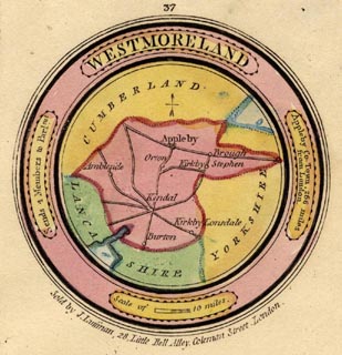 click to enlarge click to enlargeLUF4Wd.jpg "WESTMORELAND is 45 miles in length from east to west, and 33 in breadth from north to south. It is divided into 2 baronies, which contain 8 market towns, 26 parishes, 8,212 houses; and the population amounts to 41,617." "The air is clear, sharp, and healthy; the soil various; the mountainous part very barren, and the vales altogether as fertile. Copper mines, and, it is said, some veins of gold, are in the mountains. The hams cured in this county are of excellent flavour. The principal rivers are the Eden, the Lone, and the Ken. It has also several fine lakes, the chief of which is Winander-Mere." item:- Dove Cottage : 2007.38.46 Image © see bottom of page |
|||||||||||||||||||||||||||||||||||||||
|
|
||||||||||||||||||||||||||||||||||||||||
| evidence:- | old map:- Cooper 1808 placename:- Westmoreland item:- population, Westmorland; Westmorland, size; Westmorland, population |
|||||||||||||||||||||||||||||||||||||||
| source data:- | Map, hand coloured engraving, Westmoreland ie Westmorland, scale
about 9 miles to 1 inch, by H Cooper, 1808, published by R
Phillips, Bridge Street, Blackfriars, London, 1808. click to enlarge click to enlargeCOP4.jpg "WESTMORELAND / in which is laid down every Parish &Place / containing upwards of 20 Houses. / Boroughs. ... 1 / Market Towns. ... 7 / Parishes ... 32 / Inhabited Houses. ... 7,897 / Inhabitants. ... 41,617 / Acres of Land.. ... 462,080 / Arable. ... 30,000 / Pasturage. ... 130,000" title cartouche, etc item:- Dove Cottage : 2007.38.53 Image © see bottom of page |
|||||||||||||||||||||||||||||||||||||||
|
|
||||||||||||||||||||||||||||||||||||||||
| evidence:- | old text:- Gents Mag item:- inclosure |
|||||||||||||||||||||||||||||||||||||||
| source data:- | Magazine, The Gentleman's Magazine or Monthly Intelligencer or
Historical Chronicle, published by Edward Cave under the
pseudonym Sylvanus Urban, and by other publishers, London,
monthly from 1731 to 1922. goto source Gentleman's Magazine 1808 p.940 "The Earl of Lonsdale has signified his intention of enfranchising his numerous copy-holders throughout Cumberland and Westmoreland, by which measure he will be enabled to enclose more than 20,000 acres of land in those countries, at this time in a state of commonage." |
|||||||||||||||||||||||||||||||||||||||
|
|
||||||||||||||||||||||||||||||||||||||||
| evidence:- | descriptive text:- Wallis 1810 placename:- Westmoreland |
|||||||||||||||||||||||||||||||||||||||
| source data:- | Map, Westmoreland, scale about 19 miles to 1 inch, and
Cumberland, scale about 16 miles to 1 inch, by James Wallis, 77
Berwick Street, Soho, London, 1810; published 1810-36. "Westmoreland." "Is an inland county, in the N.W. part of England, having Yorkshire on the E.; Lancashire on the S. and S.W.; and Cumberland on the N. and N.W. A part of Durham also bounds it on the N.E. It is in the province of York, is included in the northern circuit, and sends four members to parliament. It is divided into four hundreds, containing eight market-towns, and 32 parishes. The chief mannfactures (sic) are stocking and woollen cloth. Westmoreland received its name from its situation to the W., and the principal part of it being formerly moorish barren land. Population, 45,922." |
|||||||||||||||||||||||||||||||||||||||
|
|
||||||||||||||||||||||||||||||||||||||||
| evidence:- | old text:- Gents Mag placename:- Westmoreland |
|||||||||||||||||||||||||||||||||||||||
| source data:- | Magazine, The Gentleman's Magazine or Monthly Intelligencer or
Historical Chronicle, published by Edward Cave under the
pseudonym Sylvanus Urban, and by other publishers, London,
monthly from 1731 to 1922. goto source Gentleman's Magazine 1820 part 1 p.307 book review "A LITHOGRAPHIC VIEW OF THE SEVERAL COUNTIES IN ENGLAND; BY THE LATE MR. EMANUEL MENDEZ DA COSTA, F.R.S." "..." "WESTMORELAND. A county full of mines, and abounds also in many curious fossils of different kinds, as very fine cubic fluors, crystals, petrifactions, &c. Slate quarries at Troutbeck Park. Lead mines at Hartley, Kirkby Steven, &c." |
|||||||||||||||||||||||||||||||||||||||
|
|
||||||||||||||||||||||||||||||||||||||||
| evidence:- | old map:- Hall 1820 (Wmd) placename:- Westmoreland |
|||||||||||||||||||||||||||||||||||||||
| source data:- | Map, hand coloured engraving, Westmoreland ie Westmorland, scale
about 14.5 miles to 1 inch, by Sidney Hall, London, 1820,
published by Samuel Leigh, 18 Strand, London, 1820-31. click to enlarge click to enlargeHA18.jpg "Westmoreland" in title cartouche; county item:- Armitt Library : 2008.14.58 Image © see bottom of page |
|||||||||||||||||||||||||||||||||||||||
|
|
||||||||||||||||||||||||||||||||||||||||
| evidence:- | old text:- Gents Mag placename:- Westmoreland item:- education; school |
|||||||||||||||||||||||||||||||||||||||
| source data:- | Magazine, The Gentleman's Magazine or Monthly Intelligencer or
Historical Chronicle, published by Edward Cave under the
pseudonym Sylvanus Urban, and by other publishers, London,
monthly from 1731 to 1922. goto source Gentleman's Magazine 1823 part 2 p.323 "Rosegill, Oct. 2." "Mr. URBAN," "BY the Parliamentary Enquiry in 1819, respecting the Education of the lower classes in England, it was found that Westmoreland was the best educated County in the kingdom. The following is a brief account of Schools with endowment in this County; some of them are in high repute for classical acquirements, and have produced many eminent characters both in Church and State." Comments about individual schools are to found in their records: Appleby, Ambleside, Ashbby, Bampton, Barton, Bolton, Brough, Burton, Crosby Ravensworth, Dufton, Greenholme, Heversham, Kaber, Kendal, Kirkby Lonsdale, Kirkby Stephen, Lowther, Measand, Morland, Orton, Ravenstonedale, Stanemore, Swindale, Tebay, Thrimby, Waitby, and Winton. |
|||||||||||||||||||||||||||||||||||||||
|
|
||||||||||||||||||||||||||||||||||||||||
| evidence:- | descriptive text:- Otley 1823 (5th edn 1834) item:- boundary; county boundary; geology |
|||||||||||||||||||||||||||||||||||||||
| source data:- | Guide book, A Concise Description of the English Lakes, the
mountains in their vicinity, and the roads by which they may be
visited, with remarks on the mineralogy and geology of the
district, by Jonathan Otley, published by the author, Keswick,
Cumberland now Cumbria, by J Richardson, London, and by Arthur
Foster, Kirkby Lonsdale, Cumbria, 1823; published 1823-49,
latterly as the Descriptive Guide to the English Lakes. goto source Page 1:- "DESCRIPTION OF THE ENGLISH LAKES AND ADJACENT MOUNTAINS." "THE LAKES." "THE Mountainous District, in which the English Lakes are situated, extends into three Counties, Cumberland, Westmorland, and Lancashire, which form their junction at a point upon the mountain Wrynose, near the road side. Lancashire is separated from Cumberland by the river Duddon; from Westmorland by the stream running through Little Langdale, and by Elterwater and Windermere, until south of Storrs Hall; after which the river Winster forms the boundary till it enters the sands near Medup; and the latter county is parted from Cumberland by the mountain ridge leading over Bowfell to Dunmail Raise, from thence over the top of Helvellyn, and through Glencoin" goto sourcePage 2:- "to Ullswater, and by the river Eamont till it enters the Eden. Windermere Lake is said to belong to Westmorland, at least its islands are claimed by that county; although the whole of its western and part of its eastern shores belong to Lancashire. Coniston and Esthwaite Lakes, with Blelham and the tarns of Coniston, are wholly in Lancashire. Grasmere, Rydal, and Hawes Water, with several tarns, lie in Westmorland. The head of Ullswater is in Westmorland, but below Glencoin it constitutes the boundary between that and Cumberland. Derwent, Bassenthwaite, Buttermere, Ennerdale, and Wastwater, are in Cumberland." goto source"... The road entering Lancashire at Brathay, or at Skelwith Bridge, leaves it again at Colwith Bridge; ..." goto source"... Near the road on Wrynose are the three shire stones of Cumberland, Westmorland, and Lancashire." goto sourcePage 110:- "... Dunmail Raise ... At the highest part of the road, a wall separates the counties of Westmorland and Cumberland; ..." goto sourcePage 149:- "THE GEOLOGY OF THE LAKE DISTRICT." "AT the time this essay was first published, the structure of the mountainous district of Cumberland, Westmorland, and Lancashire, was but little understood; scientific travellers had contented themselves with procuring specimens of the different rocks, without taking time to become acquainted with their relative position. Since then, the subject has received more attention from persons conversant with geological inquiries; especially from the distinguished Professor Sedgwick. ..." |
|||||||||||||||||||||||||||||||||||||||
|
|
||||||||||||||||||||||||||||||||||||||||
| evidence:- | old map:- Perrot 1823 placename:- Westmoreland |
|||||||||||||||||||||||||||||||||||||||
| source data:- | Map, hand coloured engraving, Cumberland and Westmoreland ie
Westmorland, scale about 38 miles to 1 inch, by Aristide Michel
Perrot, engraved by Migneret, 1823, published by Etienne Ledoux,
9 Rue Guenegaud, Paris, France, 1824-48. click to enlarge click to enlargePER2.jpg "WESTMORELAND" county item:- Dove Cottage : 2007.38.45 Image © see bottom of page |
|||||||||||||||||||||||||||||||||||||||
|
|
||||||||||||||||||||||||||||||||||||||||
| Gents Mag 1825 |
||||||||||||||||||||||||||||||||||||||||
|
|
||||||||||||||||||||||||||||||||||||||||
| evidence:- | old map:- Cobbett 1832 placename:- WESTMORELAND |
|||||||||||||||||||||||||||||||||||||||
| source data:- | Map, uncoloured engraving, Westmoreland ie Westmorland, scale
about 7 miles to 1 inch, by William Cobbett, 11 Bolt Court,
Fleet Street, London, 1832. click to enlarge click to enlargeCOB4.jpg "WESTMORELAND" in a plain cartouche; the county shape is badly distorted item:- JandMN : 116 Image © see bottom of page |
|||||||||||||||||||||||||||||||||||||||
|
|
||||||||||||||||||||||||||||||||||||||||
| evidence:- | descriptive text:- Ford 1839 (3rd edn 1843) placename:- Westmorland |
|||||||||||||||||||||||||||||||||||||||
| source data:- | Guide book, A Description of Scenery in the Lake District, by
Rev William Ford, published by Charles Thurnam, Carlisle, by W
Edwards, 12 Ave Maria Lane, Charles Tilt, Fleet Street, William
Smith, 113 Fleet Street, London, by Currie and Bowman,
Newcastle, by Bancks and Co, Manchester, by Oliver and Boyd,
Edinburgh, and by Sinclair, Dumfries, 1839. goto source "THE Lake district extends over a portion of the three counties of Cumberland, Westmorland, and Lancashire, being bounded on the south and west by the sea, which combines beautifully from many elevated points with the inland scenery, and occupying an area of about thirty miles in diameter. It consists of large masses or clusters of mountains, generally terminating in one aspiring and pre-eminent point, with the intermediate valleys occupied either by lakes and their subsidiary tarns, or by winding rivers." |
|||||||||||||||||||||||||||||||||||||||
|
|
||||||||||||||||||||||||||||||||||||||||
| evidence:- | old text:- Gents Mag placename:- Westmerland item:- placename, Westmorland |
|||||||||||||||||||||||||||||||||||||||
| source data:- | Magazine, The Gentleman's Magazine or Monthly Intelligencer or
Historical Chronicle, published by Edward Cave under the
pseudonym Sylvanus Urban, and by other publishers, London,
monthly from 1731 to 1922. goto source Gentleman's Magazine 1849 part 2 p.450 "M. C. requests us to mention the authority on which one of our northern counties is written Westmerland. In answer, we beg to say that the county derives the etymology of its name decidedly from its being the "land of the western meres," - not the moors, as the modern mode of writing it seems to have suggested. In no old authority, either written or printed, will the name be found spelled otherwise than Westmerland." |
|||||||||||||||||||||||||||||||||||||||
|
|
||||||||||||||||||||||||||||||||||||||||
| evidence:- | old map:- placename:- Westmorland |
|||||||||||||||||||||||||||||||||||||||
| source data:- | Map, hand coloured engraving, wood jigsaw puzzle, England, scale
about 26 miles to 1 inch, by Gall and Inglis, Bernard Terrace,
Edinburgh, and 25 Paternoster Square, London, cut by E J
Peacock, King's Cross, London, 1850s?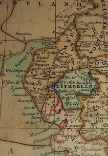 click to enlarge click to enlargeBXX11.jpg Map, hand coloured engraving, wood jigsaw puzzle, England, scale about 26 miles to 1 inch, by Gall and Inglis, Bernard Terrace, Edinburgh, and 25 Paternoster Square, London, cut by E J Peacock, King's Cross, London, 1850s? printed on box lid:- "A / DISSECTED / MAP / OF / ENGLAND / Manufactured by E. J. PEACOCK, 10 Upper [W house] Street, King's Cross." printed on jigsaw "WESTMORLAND" item:- JandMN : JIG388 Image © see bottom of page |
|||||||||||||||||||||||||||||||||||||||
|
|
||||||||||||||||||||||||||||||||||||||||
| evidence:- | old text:- Martineau 1855 item:- map; compass; walking; county boundary mark |
|||||||||||||||||||||||||||||||||||||||
| source data:- | Guide book, A Complete Guide to the English Lakes, by Harriet
Martineau, published by John Garnett, Windermere, Westmorland,
and by Whittaker and Co, London, 1855; published 1855-76. goto source Page 57:- "A DAY ON THE MOUNTAINS." "... There is one thing more that he [the stranger] must do before he goes on into Cumberland. He must spend a day on the Mountains: and if alone, so much the better. If he knows what it is to spend a day so far above the every-day world, he is aware that it is good to be alone, (unless there is danger in the case); and, if he is a novice, let him try whether it be not so. Let him go forth early with a stout stick in his hand, provision for the day in his knapsack or his pocket; and, if he choose, a book: but we do not think he will read to-day. A map is essential, to explain to him what he sees: and it is very well to have a pocket compass, in case of sudden fog, or any awkward doubt about the way. In case of an ascent of a formidable mountain, like Scawfell or Helvellyn, it is rash to go without a guide: but our tourist shall undertake something more moderate, and reasonably safe, for a beginning." goto sourcePage 165:- "... There are two cairns on two summits [of Helvellyn], not far apart, ... These Men, (as such piles of stones are called) mark the" goto sourcePage 166:- "dividing line between Cumberland and Westmorland. ..." |
|||||||||||||||||||||||||||||||||||||||
|
|
||||||||||||||||||||||||||||||||||||||||
| evidence:- | old text:- Harper 1907 placename:- Westmoreland placename:- Westmereland placename:- Westmoringaland item:- placename, Westmorland |
|||||||||||||||||||||||||||||||||||||||
| source data:- | Guidebook, The Manchester and Glasgow Road, by Charles G Harper,
published by Chapman and Hall Ltd, London, 1907. HP01p098.txt Page 98:- "And here we are in Westmoreland. Authorities have not yet done disputing whether it was originally "Westmoreland," or "Westmereland," for the moors and meres, i.e. the lakes, are equally prominent in the county; and by the same token, there is no settled spelling of the name "Westmoreland"; with two "e's" or with one. The one "e" appears to be now the more favoured of these versions, but, for my part, I plump for the more romantic-looking old style." "Westmoreland was originally styled by the Saxons "Westmoringaland," the land occupied by the people of the west moors. But the name of the county does not, it would appear, derive from that olden style, but from "Westmerieland," a name which seems to have originated in Norman times and means "the land of the west meres"; Windermere, Grasmere, and other lakes that in modern times confer upon Westmoreland the popular title of the "Lake Country," having thus early appealed to observers as the distinguishing feature of the district." |
|||||||||||||||||||||||||||||||||||||||
|
|
||||||||||||||||||||||||||||||||||||||||
| evidence:- | old map:- County Associations 1950 placename:- Westmorland |
|||||||||||||||||||||||||||||||||||||||
| source data:- | Map, colour lithograph, Westmorland, scale about 5 miles to 1 inch, published by The
County Associations, Bourdon Street, Berkeley Square, London, 1950.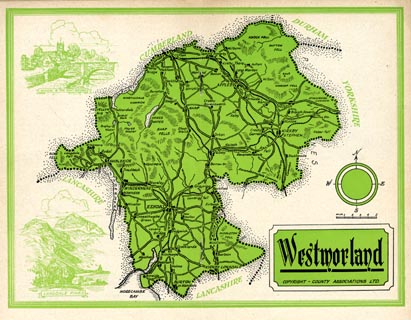 click to enlarge click to enlargeWMD1M4.jpg Map, colour lithograph, Westmorland, scale about 5 miles to 1 inch, published in The Westmorland Official County Guide by The County Associations, Bourdon Street, Berkeley Square, London, 1950. item:- JandMN : 1000.4 Image © see bottom of page |
|||||||||||||||||||||||||||||||||||||||
|
|
||||||||||||||||||||||||||||||||||||||||
| Westmorland, Population |
||||||||||||||||||||||||||||||||||||||||
| Figures from Census returns. |
||||||||||||||||||||||||||||||||||||||||
|
||||||||||||||||||||||||||||||||||||||||
|
|
||||||||||||||||||||||||||||||||||||||||
| new county:- | Cumbria |
|||||||||||||||||||||||||||||||||||||||
|
|
||||||||||||||||||||||||||||||||||||||||
Lakes Guides menu.