 Old Cumbria Gazetteer
 |
 |
|
|
| included in:- |
 road, Ambleside to Ravenglass to Skelwith Bridge road, Ambleside to Ravenglass to Skelwith Bridge
|
||
| road, Ambleside to Coniston | |||
| Ambleside to Coniston | |||
| Coniston to Ambleside | |||
| A593 | |||
| civil parish:- | Lakes (formerly Westmorland) | ||
| civil parish:- | Skelwith (formerly Lancashire) | ||
| civil parish:- | Hawkshead (formerly Lancashire) | ||
| civil parish:- | Coniston (formerly Lancashire) | ||
| county:- | Cumbria | ||
| locality type:- | road route | ||
| 10Km square:- | NY30 | ||
| 10Km square:- | SD29 | ||
|
|
|||
| evidence:- | old map:- Jefferys 1770 (Wmd) |
||
| source data:- | Map, 4 sheets, The County of Westmoreland, scale 1 inch to 1
mile, surveyed 1768, and engraved and published by Thomas
Jefferys, London, 1770.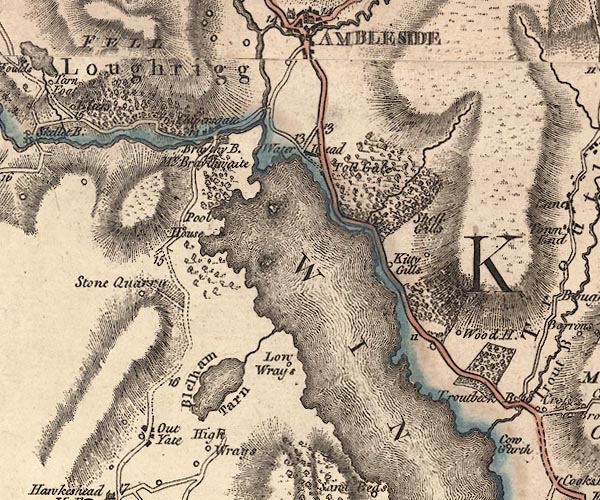 J5NY30SE.jpg double line; road, with mile numbers item:- National Library of Scotland : EME.s.47 Image © National Library of Scotland |
||
|
|
|||
| evidence:- | descriptive text:- West 1778 (11th edn 1821) |
||
| source data:- | Guide book, A Guide to the Lakes, by Thomas West, published by
William Pennington, Kendal, Cumbria once Westmorland, and in
London, 1778 to 1821. goto source Page 54:- "..." "At Water-head, the road to the east leads to Ambleside, eight miles; to Hawkshead, three. Ascend a steep hill surronded (sic) with" goto sourcePage 55:- "wood, and have a back view of the lake. ... turn your face to the east, and you have a view of some part of Windermere-water. The road soon divides; the left leads to Ambleside, the right to Hawkshead, which stands under a mountain, at the upper end of a narrow valley. The church is seated on the front of an eminence that commands the vale, which is floated with" |
||
|
|
|||
| evidence:- | old map:- Crosthwaite 1783-94 (Con) |
||
| source data:- | Map, uncoloured engraving, An Accurate Map of Coniston Lake,
scale about 3 inches to 1 mile, by Peter Crosthwaite, Keswick,
Cumberland, 1788, version published 1809.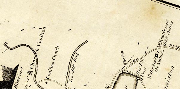 CTESD39E.jpg 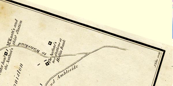 CTESD39J.jpg "to Waterhead and Broughton" double line item:- JandMN : 182.5 Image © see bottom of page |
||
|
|
|||
| evidence:- | old map:- Clarke 1787 map (Windermere N) |
||
| source data:- | Map, A Map of the Northern Part of the Lake Winandermere and its
Environs, scale about 6.5 ins to 1 mile, by James Clarke,
engraved by Samuel John Neele, 352 Strand, published by James
Clarke, Penrith, Cumberland and in London etc, 1787.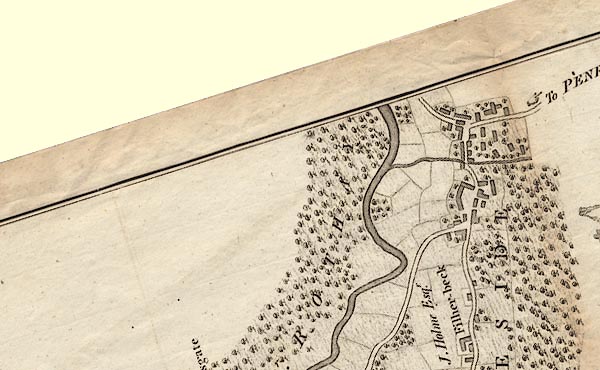 CLANY30S.jpg 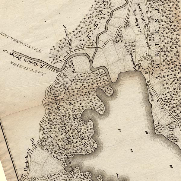 CLANY30R.jpg "To Skellett Bridge" On south side of the river, and an alternative road on the north side. item:- private collection : 10.10 Image © see bottom of page |
||
|
|
|||
| evidence:- | descriptive text:- Otley 1823 (5th edn 1834) item:- road distances |
||
| source data:- | Guide book, A Concise Description of the English Lakes, the
mountains in their vicinity, and the roads by which they may be
visited, with remarks on the mineralogy and geology of the
district, by Jonathan Otley, published by the author, Keswick,
Cumberland now Cumbria, by J Richardson, London, and by Arthur
Foster, Kirkby Lonsdale, Cumbria, 1823; published 1823-49,
latterly as the Descriptive Guide to the English Lakes. goto source Page 97:- "From Coniston, those who feel no hesitation in crossing the Ferry on Windermere, may proceed through Hawkshead, by the side of Esthwaite Water, to the Ferry; and after taking a view of Windermere, from Mr. Curwen's Station-house, cross the water to Bowness, distant from Coniston Water-head 9 miles. Those who object to crossing the water, may either proceed from Coniston to Ambleside direct, 8 miles; or from the Ferry, by the western banks of the lake to Ambleside, distant from Coniston by this route 14 miles." |
||
|
|
|||
| evidence:- | old map:- Prior 1874 map 1 |
||
| source data:- | Map, uncoloured engraving or lithograph? Winander Mere, scale
about 2.5 miles to 1 inch, published by John Garnett,
Windermere, Westmorland, 1874. click to enlarge click to enlargePI03M1.jpg "To Skelwith Br. &Langdale @q To Coniston" double line; road, two routes item:- private collection : 133.1 Image © see bottom of page |
||
|
|
|||
| evidence:- | gradient diagram:- Gall and Inglis 1890s-1900s (Roads) |
||
| source data:- | Contour Road Book of England, Northern Division, by Harry R G Inglis, published by
Gall and Inglis, 25 Paternoster Square, London and Edinburgh, 1898.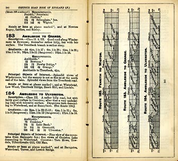 click to enlarge click to enlargeIG5183.jpg Itinerary, with gradient diagram, route 183, Ambleside to Grange, and route184, Ambleside to Ulverston, Westmorland and Lancashire, 1898. item:- JandMN : 763.17 Image © see bottom of page |
||
|
|
|||
| evidence:- | gradient diagram:- Gall and Inglis 1890s-1900s (Roads) |
||
| source data:- | Contour Road Book of England, Northern Division, by Harry R G Inglis, published by
Gall and Inglis, 25 Paternoster Square, London and Edinburgh, 1898.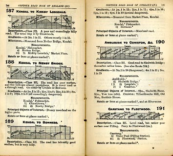 click to enlarge click to enlargeIG5187.jpg Itinerary, with gradient diagram, routes 187, Kendal to Kirkby Lonsdale, 188, Kendal to Newby Bridge, 189, Kendal to Bowness, and 190, Ambleside to Coniston etc, Westmorland and Lancashire, 1898. item:- JandMN : 763.19 Image © see bottom of page |
||
|
|
|||
| evidence:- | old strip map:- Rumney 1899 |
||
| source data:- | Road map, strip map, gradient diagram, and itinerary for Route VI, Ambleside to Coniston
by Barngates, Westmorland and Lancashire, scale about 2 miles to 1 inch, by A W Rumney,
published by George Philip and Son, 32 Fleet Street, London, and Liverpool, 1899.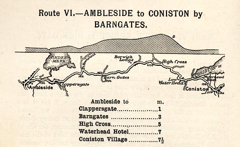 click to enlarge click to enlargeRUM108.jpg On p.30 of the Cyclist's Guide to the English Lake District, by A W Rumney. printed at top:- "Route VI. - AMBLESIDE TO CONISTON by / BARNGATES." item:- JandMN : 147.9 Image © see bottom of page |
||
|
|
|||
| evidence:- | old strip map:- Rumney 1899 |
||
| source data:- | Road map, strip map, gradient diagram, and itinerary for Route VII, Coniston to Ambleside
by Oxenfell, Lancashire and Westmorland, scale about 2 miles to 1 inch, by A W Rumney,
published by George Philip and Son, 32 Fleet Street, London, and Liverpool, 1899.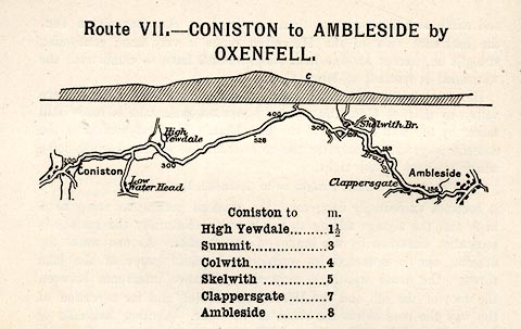 click to enlarge click to enlargeRUM109.jpg On p.32 of the Cyclist's Guide to the English Lake District, by A W Rumney. printed at top:- "Route VII. - CONISTON to AMBLESIDE by / OXENFELL." item:- JandMN : 147.10 Image © see bottom of page |
||
|
|
|||
| places:- | Ambleside Clappersgate, Lakes Skelwith Bridge, Lakes Coniston |
||
|
|
|||
| places:- | old route Ambleside Clappersgate, Lakes Drunken Duck, Hawkshead Borwick Lodge, Hawkshead Coniston |
||
|
|
|||
Lakes Guides menu.