 Old Cumbria Gazetteer
 |
 |
|
||||||||||||||||||||||||
| Black Combe, Whicham | ||||||||||||||||||||||||||
| Black Combe | ||||||||||||||||||||||||||
| civil parish:- | Whicham (formerly Cumberland) | |||||||||||||||||||||||||
| county:- | Cumbria | |||||||||||||||||||||||||
| locality type:- | hill | |||||||||||||||||||||||||
| coordinates:- | SD13548548 (summit) | |||||||||||||||||||||||||
| 1Km square:- | SD1385 | |||||||||||||||||||||||||
| 10Km square:- | SD18 | |||||||||||||||||||||||||
| altitude:- | 1969 feet | |||||||||||||||||||||||||
| altitude:- | 600m | |||||||||||||||||||||||||
|
|
||||||||||||||||||||||||||
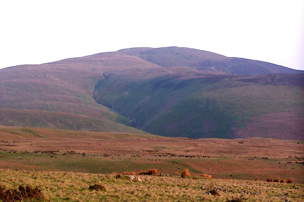 BMC35.jpg (taken 11.5.2006) 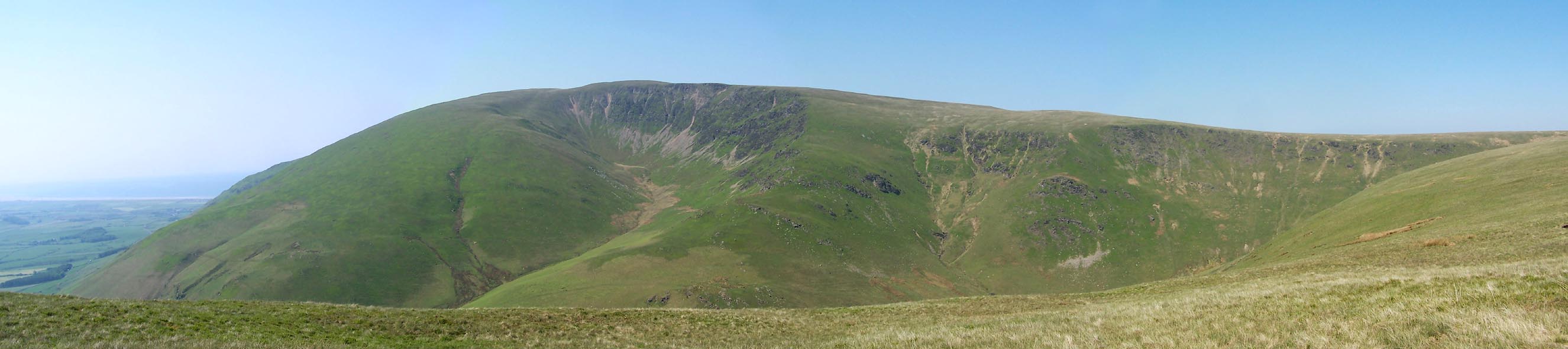 Click to enlarge BWQ68.jpg From White Combe. (taken 27.5.2012) |
||||||||||||||||||||||||||
|
|
||||||||||||||||||||||||||
| evidence:- | old map:- OS County Series (Cmd 88 1) placename:- Black Combe |
|||||||||||||||||||||||||
| source data:- | Maps, County Series maps of Great Britain, scales 6 and 25
inches to 1 mile, published by the Ordnance Survey, Southampton,
Hampshire, from about 1863 to 1948. |
|||||||||||||||||||||||||
|
|
||||||||||||||||||||||||||
| evidence:- | descriptive text:- Fiennes 1698 placename:- item:- graphite; black lead |
|||||||||||||||||||||||||
| source data:- | Travel book, manuscript record of Journeys through England
including parts of the Lake District, by Celia Fiennes, 1698. "on the Castle tower walking quite round by the battlements I saw ... into Cumberland to the great hill called Black Comb Hill whence they digg their black lead [graphite] and no where else, but they open the mine but once in severall yeares; ..." |
|||||||||||||||||||||||||
|
|
||||||||||||||||||||||||||
| evidence:- | old map:- Donald 1774 (Cmd) placename:- Black Comb |
|||||||||||||||||||||||||
| source data:- | Map, hand coloured engraving, 3x2 sheets, The County of Cumberland, scale about 1
inch to 1 mile, by Thomas Donald, engraved and published by Joseph Hodskinson, 29
Arundel Street, Strand, London, 1774.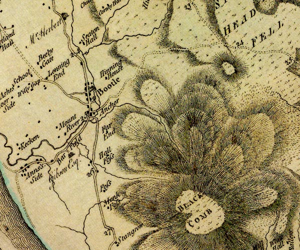 D4SD18NW.jpg 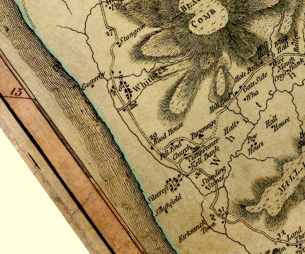 D4SD18SW.jpg "BLACK COMB" hill hachuring; a hill or mountain item:- Carlisle Library : Map 2 Images © Carlisle Library |
|||||||||||||||||||||||||
|
|
||||||||||||||||||||||||||
| evidence:- | old text:- Mackenzie 1776 placename:- Black Comb Hill |
|||||||||||||||||||||||||
| source data:- | Charts, and sailing directions, Nautical Descriptions of the
West Coast of Great Britain, Bristol Channel to Cape Wrath, by
Murdoch Mackenzie, published London, 1776. goto source goto sourcePage 18:- "... ..." "To sail into Piel-of-Foudray from the N.; take half-flood, and keep Black-comb Hill out by Walney (to avoid Helpsford Sand) ..." |
|||||||||||||||||||||||||
|
|
||||||||||||||||||||||||||
| evidence:- | old map:- West 1784 map placename:- Black Comb |
|||||||||||||||||||||||||
| source data:- | Map, hand coloured engraving, A Map of the Lakes in Cumberland,
Westmorland and Lancashire, scale about 3.5 miles to 1 inch,
engraved by Paas, 53 Holborn, London, about 1784.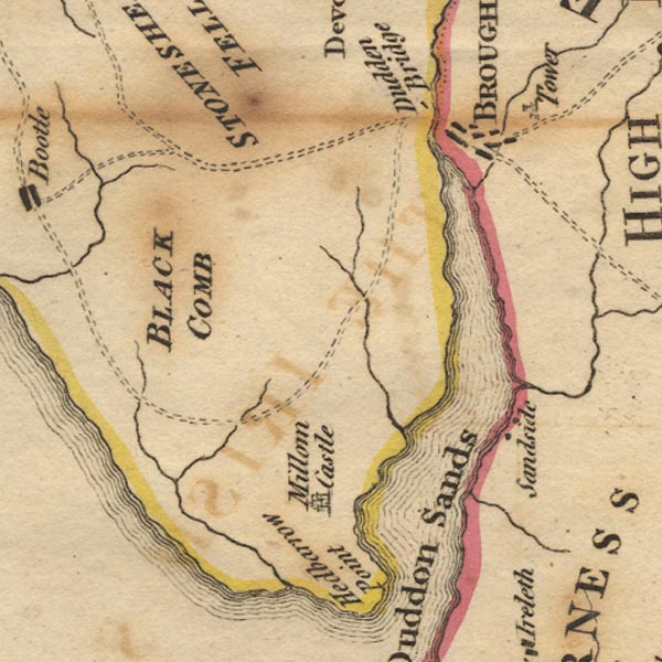 Ws02SD18.jpg "BLACK COMB" item:- Armitt Library : A1221.1 Image © see bottom of page |
|||||||||||||||||||||||||
|
|
||||||||||||||||||||||||||
| evidence:- | old map:- Aikin 1790 (Cmd) placename:- Black Comb Hill |
|||||||||||||||||||||||||
| source data:- | Map, uncoloured engraving, Cumberland, by John Aikin, London,
1790. click to enlarge click to enlargeAIK3.jpg "Black Comb Hill" no symbol; hill item:- JandMN : 145 Image © see bottom of page |
|||||||||||||||||||||||||
|
|
||||||||||||||||||||||||||
| evidence:- | old map:- Cooke 1802 placename:- Black Comb |
|||||||||||||||||||||||||
| source data:- | Map, The Lakes, Westmorland and Cumberland, scale about 8.5
miles to 1 inch, engravedby Neele and Son, published by
Sherwood, Jones and Co, Paternoster Road, London, 1824. click to enlarge click to enlargeGRA1Lk.jpg "Black Comb" hillock; mountain item:- Hampshire Museums : FA2000.62.5 Image © see bottom of page |
|||||||||||||||||||||||||
|
|
||||||||||||||||||||||||||
| evidence:- | old text:- Capper 1808 placename:- Blackcomb |
|||||||||||||||||||||||||
| source data:- | Gazetteer, A Topographical Dictionary of the United Kingdom,
compiled by Benjamin Pitts Capper, published by Richard
Phillips, Bridge Street, Blackfriars, London, 1808; published
1808-29. goto source "[Millom Castle] ... with an extensive park, beyond which rises Blackcomb mountain; whence in a clear day, may be distinctly seen seven English counties, and a great part of Scotland, Wales, and the Isle of Man. ..." |
|||||||||||||||||||||||||
|
|
||||||||||||||||||||||||||
| evidence:- | old map:- Cooper 1808 placename:- Black Comb |
|||||||||||||||||||||||||
| source data:- | Map, uncoloured engraving, Cumberland, scale about 10.5 miles to
1 inch, drawn and engraved by Cooper, published by R Phillips,
Bridge Street, Blackfriars, London, 1808. click to enlarge click to enlargeCOP3.jpg "Black Comb" hill hachuring; mountain or hill item:- JandMN : 86 Image © see bottom of page |
|||||||||||||||||||||||||
|
|
||||||||||||||||||||||||||
| evidence:- | old text:- Wordsworth 1810 placename:- Black Comb item:- viewpoint; Minstrels of Windermere |
|||||||||||||||||||||||||
| source data:- | Guide book, A Description of the Scenery of the Lakes, later A
Guide through the District of The Lakes, by William Wordsworth,
1810-35. goto source page x "... the solitary Mountain Black Comb, the summit of which, as that experienced surveyor, Colonel Mudge, declared, commands a more extensive view than any point in Britain. Ireland he saw more than once, but not when the sun was above the horizon." ""Close by the Sea, lone sentinel, Black-Comb his forward station keeps; He breaks the sea's tumultuous swell,- And ponders o'er the level deeps." "He listens to the bugle horn, Where Eskdale's lovely valley bends; Eyes Walney's early fields of corn; Sea-birds to Holkers's woods he sends." "Beneath his feet the sunk ship rests, In Duddon Sands, its masts all bare: ... ... ... ... ... ..."" "The Minstrels of Windermere, by Chas. Farish, B.D." "..." |
|||||||||||||||||||||||||
|
|
||||||||||||||||||||||||||
| evidence:- | old map:- Otley 1818 placename:- Black Combe |
|||||||||||||||||||||||||
| source data:- | Map, uncoloured engraving, The District of the Lakes,
Cumberland, Westmorland, and Lancashire, scale about 4 miles to
1 inch, by Jonathan Otley, 1818, engraved by J and G Menzies,
Edinburgh, Scotland, published by Jonathan Otley, Keswick,
Cumberland, et al, 1833.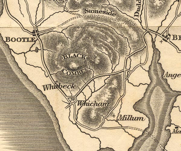 OT02SD18.jpg "BLACK COMBE" item:- JandMN : 48.1 Image © see bottom of page |
|||||||||||||||||||||||||
|
|
||||||||||||||||||||||||||
| evidence:- | outline view:- Otley 1823 (4th edn 1830) placename:- Black Combe |
|||||||||||||||||||||||||
| source data:- | Print, engraving, outline view, Some of the Western Mountains as seen from Helvellyn,
published by Jonathan Otley, Keswick, Cumberland et al, 1830.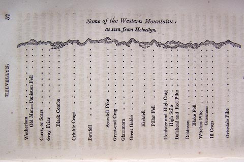 click to enlarge click to enlargeO75E02.jpg p.57 in A Concise Description of the English Lakes, by Jonathan Otley, 4th edition, 1830. "Some of the Western Mountains: / as seen from Helvellyn." "Wetherlam / Old Man - Coniston Fell / Carrs, or Scars / Gray Friar / Black Combe / Crinkle Crags / Bowfell / Scawfell Pike / Great-end Crag / Glaramara / Great Gable / Kirkfell / Pillar Fell / Honister and High Crag / High Stile / Dalehead and Red Pike / Robinson / Blake Fell / Witeless Pike / Grasmoor / Ill Crags / Grisedale Pike" item:- Armitt Library : A1175.3 Image © see bottom of page |
|||||||||||||||||||||||||
|
|
||||||||||||||||||||||||||
| evidence:- | outline view:- Otley 1823 (8th edn 1849) placename:- Black Comb |
|||||||||||||||||||||||||
| source data:- | Engraving, outline view of mountains, A Group of Mountains seen from Helvellyn, looking
towards the South West, drawn by T Binns, engraved by O Jewitt, opposite p.50 of A
Descriptive Guide of the English Lakes, by Jonathan Otley, 8th edition, 1849.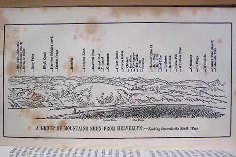 click to enlarge click to enlargeO80E17.jpg item:- Armitt Library : A1180.18 Image © see bottom of page |
|||||||||||||||||||||||||
|
|
||||||||||||||||||||||||||
| evidence:- | outline view:- Otley 1823 (5th edn 1834) |
|||||||||||||||||||||||||
| source data:- | Print, woodcut outline view, A Group of Mountains, seen from
Helvellyn, by Jonathan Otley, Keswick, Cumberland, 1830.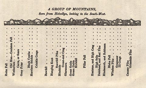 click to enlarge click to enlargeOT2E09.jpg Printed on p.63 of A Concise Description of the English Lakes, by Jonathan Otley, 5th edition, 1834. "A GROUP OF MOUNTAINS, Seen from Helvellyn, looking to the South-West." "Holm Fell / Old Man - Coniston Fell / Wetherlam / Carrs, or Scars / Gray Friar / Black Combe / Harrison Stickle / Crinkle Crags / Bowfell / Hanging Knot / Scawfell Pike / Hindside / Great-end Crag / Glaramara / Great Gable / Green Gable / Kirkfell / Pillar Fell / Honister, and High Crag / High Stile / Dalehead, and Red Pike / Hindscarth, and Robinson / Blake Fell / Witeless Pike / Grasmoor / Ill Crags / Causey Pike / Grisedale Pike" item:- JandMN : 48.10 Image © see bottom of page |
|||||||||||||||||||||||||
|
|
||||||||||||||||||||||||||
| evidence:- | descriptive text:- Otley 1823 (5th edn 1834) placename:- Black Coom item:- triangulation station; trig point; Mudge, Colonel; altitude, Black Combe; geology; peat; viewpoint; latitude; longitude; lat and long |
|||||||||||||||||||||||||
| source data:- | Guide book, A Concise Description of the English Lakes, the
mountains in their vicinity, and the roads by which they may be
visited, with remarks on the mineralogy and geology of the
district, by Jonathan Otley, published by the author, Keswick,
Cumberland now Cumbria, by J Richardson, London, and by Arthur
Foster, Kirkby Lonsdale, Cumbria, 1823; published 1823-49,
latterly as the Descriptive Guide to the English Lakes. goto source Page 72:- "BLACK COMBE, OR COOM," "Stands near the southern boundary of Cumberland. Forming the extremity of the mountain chain, it may be seen at a great distance; and is a fine station both for land and sea prospects. In 1808, it was made one of Colonel Mudge's stations, in the process of the Trigonometrical Survey. He calculated its height to be 1919 feet above the level of the sea. Its substance is a rock of clay-slate similar to that of Skiddaw, covered by a large tract of peat earth, which is cut for fuel, and brought down on different sides of the mountain. By the misprint of a single figure in the longitude of this mountain in the 3rd vol. of the Trigonometrical Survey, a great distortion has been caused in some maps lately constructed upon that basis." goto sourcePage 78:- "STATION I.- SCAWFELL highest point, THE PIKES." "Latitude 54° 27′ 24″ N. Longitude 3° 12′W. " "..." "Black Combe, Cumberland BEARINGS 19 SW Distances in miles 15 Height in feet 1919" "..." "STATION II.- SKIDDAW." "Latitude 54° 39′ 12″ N. Longitude 3° 8′ 9″W. " "..." "Black Combe BEARINGS 15 SW Distances in miles 29 Height in feet 1919" "..." goto sourcePage 79:- "STATION IV.- CONISTON OLD MAN." "Latitude 54° 22′ 20″ N. Longitude 3° 6′ 34″W. " "..." "Black Combe BEARINGS 46 SW Distances in miles 12 Height in feet 1919" "..." goto sourcePage 152:- "The greatest bulk of these mountain rocks have been commonly included under the general appellation of slate; although many of them shew no disposition to the slaty cleavage. They may be classed in three principal divisions." "Of these divisions, the FIRST or lowest in the series, ... after being lost for several miles, it is elevated again at Black Combe." "..." |
|||||||||||||||||||||||||
|
|
||||||||||||||||||||||||||
| evidence:- | descriptive text:- Ford 1839 (3rd edn 1843) placename:- Blackcomb placename:- Blackcombe placename:- Black Combe item:- altitude, Black Combe |
|||||||||||||||||||||||||
| source data:- | Guide book, A Description of Scenery in the Lake District, by
Rev William Ford, published by Charles Thurnam, Carlisle, by W
Edwards, 12 Ave Maria Lane, Charles Tilt, Fleet Street, William
Smith, 113 Fleet Street, London, by Currie and Bowman,
Newcastle, by Bancks and Co, Manchester, by Oliver and Boyd,
Edinburgh, and by Sinclair, Dumfries, 1839. goto source "... THE Lake district ... consists of large masses or clusters of mountains, generally terminating in one aspiring and pre-eminent point, with the intermediate valleys occupied either by lakes and their subsidiary tarns, or by winding rivers." "The chief nuclei of these clusters are, Skiddaw and Blencathra, Helvellyn, Fairfield, Coniston Old Man, Blackcomb, Scafell, Gable, Red Pike, Grasmoor, Grisdale Pike, and the Langdale Pikes. Many noble and commanding mountains rise around these, rivalling them in height and grandeur, but still" goto sourcePage iv:- "serving as large buttresses only. In the presentation of endlessly-diversified forms, these Mountains yield to none, however individually inferior they may be, owing to their being seldom seen in a detached point of view; although, on the other hand, they have thus the advantage of forming combinations at once grand and sublime, towering above each other, or rising in ridges, like the mighty billows of the ocean." goto sourcePage 15:- "BLACKCOMBE," "Rightly so called from the gloomy heather on its surface, may be most eligibly ascended from this town, a very gentle ascent leading to its summit. The base being at the extremity of the mountain chain, on the sea-shore between Ravenglass and the estuary of the Duddon, the prospect is one of great variety. The sublime ocean forms one-half of the circumference, with Peel Castle and the Isle of Walney on the south; in the west, the Isle of Man is a conspicuous object; the fine indented coast, the bulwark of Cumberland, trends away to the north; the towns of Egremont and Ravenglass, Bootle and Broughton, give animation to the scene; the beauties of Duddon repose at the feet; and far in the east, a mighty assemblage of mountains rear their gigantic heads." goto sourcePage 178:- "ELEVATION OF THE MOUNTAINS," "ACCORDING TO DIFFERENT AUTHORITIES."
|
|||||||||||||||||||||||||
|
|
||||||||||||||||||||||||||
| evidence:- | old map:- Ford 1839 map placename:- Black Comb |
|||||||||||||||||||||||||
| source data:- | Map, uncoloured engraving, Map of the Lake District of
Cumberland, Westmoreland and Lancashire, scale about 3.5 miles
to 1 inch, published by Charles Thurnam, Carlisle, and by R
Groombridge, 5 Paternoster Row, London, 3rd edn 1843.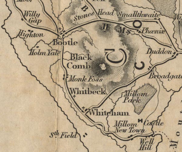 FD02SD18.jpg "Black Comb" Hill hachuring. item:- JandMN : 100.1 Image © see bottom of page |
|||||||||||||||||||||||||
|
|
||||||||||||||||||||||||||
| evidence:- | old map:- Hydrographic Office 1850s onwards placename:- Black Comb |
|||||||||||||||||||||||||
| source data:- | Chart, uncoloured engraving, England West Coast sheet XI,
Fleetwood to the Firth of Solway, scale about 2.5 miles to 1
inch, by H Denham and G Williams, 1846, engraved by J and C
Walker, published by the Hydrographic Office, 1850 corrected to
1863 coast views on Admiralty chart 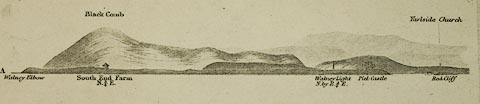 click to enlarge click to enlargeHY01P2.jpg "Black Comb" 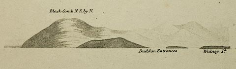 click to enlarge click to enlargeHY01P3.jpg "Black Comb ..." 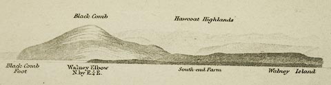 click to enlarge click to enlargeHY01P4.jpg "Black Comb Foot / Black Comb" item:- Carlisle Library : Map 93 Images © Carlisle Library |
|||||||||||||||||||||||||
|
|
||||||||||||||||||||||||||
| evidence:- | old map:- Garnett 1850s-60s H placename:- Black Comb |
|||||||||||||||||||||||||
| source data:- | Map of the English Lakes, in Cumberland, Westmorland and
Lancashire, scale about 3.5 miles to 1 inch, published by John
Garnett, Windermere, Westmorland, 1850s-60s.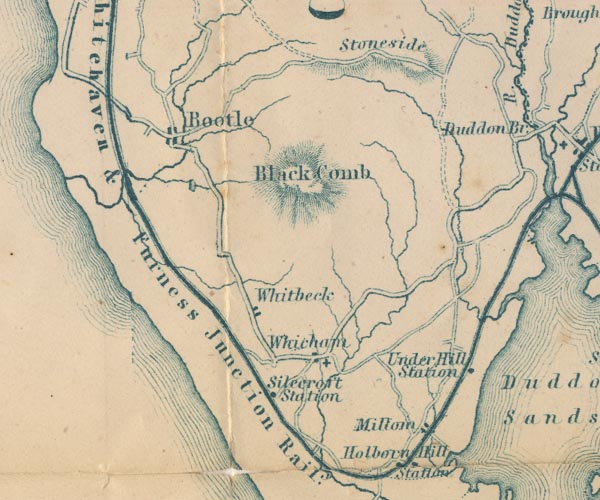 GAR2SD18.jpg "Black Comb" hill hachuring item:- JandMN : 82.1 Image © see bottom of page |
|||||||||||||||||||||||||
|
|
||||||||||||||||||||||||||
| evidence:- | old text:- Martineau 1855 placename:- Blackcombe |
|||||||||||||||||||||||||
| source data:- | Guide book, A Complete Guide to the English Lakes, by Harriet
Martineau, published by John Garnett, Windermere, Westmorland,
and by Whittaker and Co, London, 1855; published 1855-76. goto source Page 57:- "... What mountain shall it be? He might go up Blackcombe, on his way to or from Furness: and from thence he might see, in fair weather, as Wordsworth tells us, "a more extensive view than from any other point in Britain," - seven English counties, and seven" goto sourcePage 58:- "Scotch, a good deal of Wales, the Isle of Man, and in some lucky moment, just before sunrise (as the Ordnance surveyors say) the coast of Ireland. This is very fine; but it is hardly what is looked for in the lake district,- the sea being the main feature. ..." "..." goto sourcePage 107:- "... Tourists who desire to ascend Blackcombe, should do it from hence [Broughton in Furness],- the summit being only six miles from Broughton; and guides are here to be procured. Wordsworth says of this mountain that "its base covers a much greater extent of ground than any other mountain in those parts; and, from its situation, the summit commands a more extensive view than any other point in Britain." One would think that this testimony, and Col. Mudge's information that, when residing on Blackcombe for surveying purposes, he more than once saw Ireland before sunrise, would bring strangers to try their luck in seeing Scotland, Staffordshire, and Ireland, from the same point: but the mountain lies out of the ordinary track of tourists, and very few visit it." |
|||||||||||||||||||||||||
|
|
||||||||||||||||||||||||||
| evidence:- | old text:- Martineau 1855 item:- altitude, Black Combe |
|||||||||||||||||||||||||
| source data:- | Guide book, A Complete Guide to the English Lakes, by Harriet
Martineau, published by John Garnett, Windermere, Westmorland,
and by Whittaker and Co, London, 1855; published 1855-76. goto source Page 179:- "A TABLE OF THE HEIGHTS OF MOUNTAINS IN THE COUNTIES OF CUMBERLAND, WESTMORLAND, AND LANCASHIRE." "No. : Names of Mountains. : Counties. : Height in Feet above the Sea Level." "21 : Black Combe : Cumberland : 1919" |
|||||||||||||||||||||||||
|
|
||||||||||||||||||||||||||
| evidence:- | descriptive text:- Clarke 1858 placename:- Black Comb placename:- Blackcomb |
|||||||||||||||||||||||||
| source data:- | Report, Account of the Observations and Calculations of the
Principal Triangulation, by Captain Alexander Ross Clarke,
published by the Ordnance Survey, London, 1858. "BLACK COMB, 1841, is a large rocky hill in the parish of Whitbeck, in the county of Cumberland. The station is on top of the hill, and is marked by a pile of stones 14.5 feet high and 50 feet in circumference, erected above a centre stone with a hole in it 4 inches deep and an inch in diameter. The station was restored in 1852." "BLACK COMB 2-ft. Theodolite From 31st August to 29th October 1841. Observer: Lieut. DA COSTA, R.E." Objects / Bearings in degrees, minutes and decimal seconds. "Snowdon / 20 46 45.34" "South Berule / 82 42 22.61" "Snea Fell / 90 56 40.86" "North Berule / 93 24 58.62" "Cairnsmuir of Fleet / 141 4 37.06" "Merrick / 143 38 30.78" "Ben Cairn / 151 3 28.87" "Cairnsmuir on Deugh / 153 14 10.25" "Dent Hill / 159 23 6.89" "Criffel / 165 49 5.89" "Sca Fell / 199 9 18.04" "Little Whernside / 272 47 13.12" "Ingleboro' / 279 7 41.59" "Pendle Hill / 302 [17] 49.00" "Whittle Hill / 312 54 35.48" "Beryl / 337 54 38.61" Altitude above mean sea level:- "1974.3 feet" Position, latitude and longitude, degrees minutes decimal seconds "54 15 27.52 / 3 19 37.06" |
|||||||||||||||||||||||||
|
|
||||||||||||||||||||||||||
| evidence:- | old map:- Postlethwaite 1877 (3rd edn 1913) placename:- Black Combe |
|||||||||||||||||||||||||
| source data:- | Map, uncoloured engraving, Map of the Lake District Mining Field, Westmorland, Cumberland,
Lancashire, scale about 5 miles to 1 inch, by John Postlethwaite, published by W H
Moss and Sons, 13 Lowther Street, Whitehaven, Cumberland, 1877 edn 1913. PST2SD18.jpg "Black Combe" hill hachuring item:- JandMN : 162.2 Image © see bottom of page |
|||||||||||||||||||||||||
|
|
||||||||||||||||||||||||||
| evidence:- | old text:- Admiralty 1933 placename:- Black Combe |
|||||||||||||||||||||||||
| source data:- | goto source Page 384:- "... Black Combe, a dark-coloured hill which rises to an elevation of 1,956 feet (596m2) at two miles inland midway between Haverigg and Tarn points, forms a useful mark; it has an unbroken rounded outline, and the hills of Lockna banks, partly cultivated, lie a short distance southward of it, the whole being terminated seaward by a line of reddish cliff and braes. Black Combe is succeeded by high land in a northerly direction, with a well-cultivate foreground." |
|||||||||||||||||||||||||
|
|
||||||||||||||||||||||||||
| evidence:- | outline view:- Jenkinson 1875 placename:- Black Combe |
|||||||||||||||||||||||||
| source data:- | Print, lithograph, outline view, Panoramic Sketches from Helvellyn, Westmorland, by
Edwin A Pettitt, London, published by Edward Stanford, 55 Charing Cross, London, 1875. click to enlarge click to enlargeJk01E1.jpg "... Black Combe ..." item:- JandMN : 28.5 Image © see bottom of page |
|||||||||||||||||||||||||
|
|
||||||||||||||||||||||||||
| evidence:- | outline view:- Jenkinson 1875 placename:- Black Combe |
|||||||||||||||||||||||||
| source data:- | Print, lithograph, outline view, Panoramic Sketches from Skiddaw, Cumberland, by Edwin
A Pettitt, London, published by Edward Stanford, 55 Charing Cross, London, 1875. click to enlarge click to enlargeJk01E2.jpg "... Black Combe ..." item:- JandMN : 28.8 Image © see bottom of page |
|||||||||||||||||||||||||
|
|
||||||||||||||||||||||||||
| evidence:- | outline view:- Jenkinson 1875 placename:- Black Combe |
|||||||||||||||||||||||||
| source data:- | Print, lithograph, outline view, Panoramic Sketches from Scawfell Pike, Cumberland,
by Edwin A Pettitt, London, published by Edward Stanford, 55 Charing Cross, London,
1875. click to enlarge click to enlargeJk01E3.jpg "... Black Combe ..." item:- JandMN : 28.9 Image © see bottom of page |
|||||||||||||||||||||||||
|
|
||||||||||||||||||||||||||
| evidence:- | old print:- placename:- Black Combe Mountain |
|||||||||||||||||||||||||
| source data:- | Print, uncoloured engraving, View of Ravenglass, and Black Comb Mountain, Cumberland,
drawn by Joseph Farington, engraved by Letitia Byrne, published by T Cadell and W
Davies, Strand, London, 1815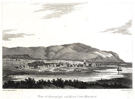 click to enlarge click to enlargePR0564.jpg printed at bottom left, right, centre:- "Drawn by Joseph Farington R.A. / Etchedby Letitia Byrne. / View of Ravenglass, and Black Comb Mountain. / Published Septr. 20, 1815, by T. cadell &W. Davies Strand." item:- Dove Cottage : 2008.107.512 Image © see bottom of page |
|||||||||||||||||||||||||
|
|
||||||||||||||||||||||||||
| evidence:- | old drawing:- Smith 1746 B placename:- Black Comb |
|||||||||||||||||||||||||
| source data:- | Drawing, pencil and ink, A View of Corno Fells and the Black Comb, in a Survey of
the Coast of Cumberland, by George Smith, 1746.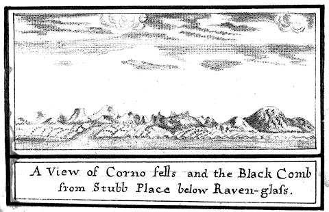 click to enlarge click to enlargeSM2101.jpg ms at bottom:- "A View of Corno fells and the Black Comb / from Stubb Place below Raven-glass." item:- Carlisle Library : 5.1 Image © Carlisle Library |
|||||||||||||||||||||||||
|
|
||||||||||||||||||||||||||
 Click to enlarge BND39.jpg From the road above Rigg Well on the side of Great Burney. (taken 2.2.2007) 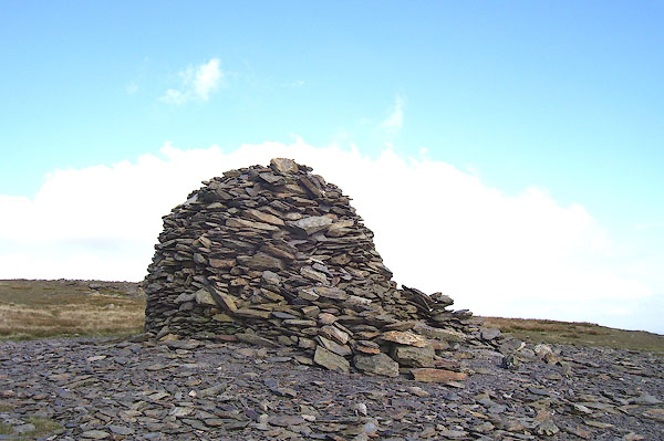 BOF70.jpg Cairn, or shelter, on the southerly summit. (taken 2.2.2007) |
||||||||||||||||||||||||||
|
|
||||||||||||||||||||||||||
| hearsay:- |
Colonel Mudge, of the Ordnance Survey, thought the view from the summit the most extensive
in Britain. You can see, sometimes, fourteen counties, the Isle of Man, and Ireland |
|||||||||||||||||||||||||
| The view to the south is said to be the greatest distance in England, to Jack Hill,
Staffordshire. |
||||||||||||||||||||||||||
|
|
||||||||||||||||||||||||||
| hearsay:- |
The beacons of west Cumberland were on: Black Combe, Boothill, Moota Hill, Muncaster
Fell, Skiddaw, St Bees Head, and Workington Hill. (Questionable information.) |
|||||||||||||||||||||||||
|
|
||||||||||||||||||||||||||
Lakes Guides menu.