Old Cumbria Gazetteer
 |
 |
|
||
| road, Longtown to Gretna | ||||
| Longtown to Gretna | ||||
| Gretna to Longtown | ||||
| A6071 | ||||
| civil parish:- | Arthuret (formerly Cumberland) | |||
| county:- | Cumbria | |||
| locality type:- | route | |||
| 10Km square:- | NY36 | |||
| country:- | Scotland | |||
| locality type:- | route | |||
| 10Km square:- | NY36 | |||
|
|
||||
| evidence:- | road map:- Cary 1790 (Cmd/edn 1789) |
|||
| source data:- | Road map, hand coloured engraving, Cumberland, scale about 15
miles to 1 inch, by John Cary, 181 Strand, London, 1790, edn
1789.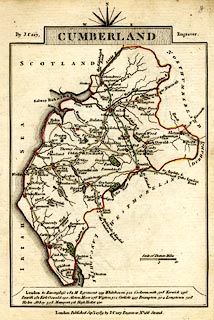 click to enlarge click to enlargeCY47.jpg double line item:- JandMN : 419 Image © see bottom of page |
|||
|
|
||||
| evidence:- | old map:- Laurie and Whittle 1806 |
|||
| source data:- | Road map, Continuation of the Roads to Glasgow and Edinburgh,
scale about 10 miles to 1 inch, by Nathaniel Coltman? 1806,
published by Robert H Laurie, 53 Fleet Street, London, 1834. click to enlarge click to enlargeLw21.jpg "To Gretna Gr p.22" double line, light bold; 'Mail-Coach Roads (Direct)' item:- private collection : 18.21 Image © see bottom of page |
|||
|
|
||||
| evidence:- | old map:- Cooper 1808 |
|||
| source data:- | Map, uncoloured engraving, Cumberland, scale about 10.5 miles to
1 inch, drawn and engraved by Cooper, published by R Phillips,
Bridge Street, Blackfriars, London, 1808. click to enlarge click to enlargeCOP3.jpg double line; road item:- JandMN : 86 Image © see bottom of page |
|||
|
|
||||
| evidence:- | old map:- Hall 1820 (Cmd) |
|||
| source data:- | Map, hand coloured engraving, Cumberland, scale about 21 miles
to 1 inch, engraved by Sidney Hall, published by S Leigh, 18
Strand, London, 1820-31. click to enlarge click to enlargeHA14.jpg "To Annan" double line, solid; main road; Longtown, Graitney, ... item:- JandMN : 91 Image © see bottom of page |
|||
|
|
||||
| evidence:- | old map:- Bell 1892 |
|||
| source data:- | Map, colour lithograph, Road Map of Cumberland, by George Joseph
Bell, scale about 2.5 miles to 1 inch, printed by Charles
Thurnam and Sons, Carlisle, Cumberland, 1892.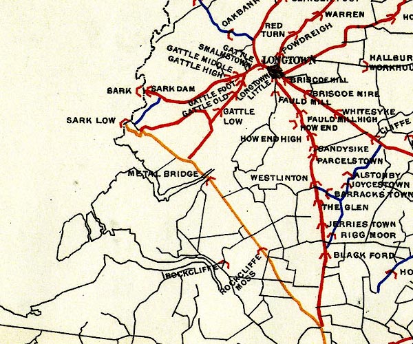 BEL9NY36.jpg red - disturnpiked 'main road' under section 13 of the Highways Act 1878 Road map of Cumberland showing County Bridges item:- Carlisle Library : Map 38 Image © Carlisle Library |
|||
|
|
||||
| evidence:- | old itinerary:- Johnson 1908 (Roads/Cum) |
|||
| source data:- | Itinerary, Route 43 in Roads Made Easy by Picture and Pen, Doncaster to Glasgow, through
Alston, by Claude Johnson, edited by Lord Montagu, published by The Car Illustrated,
168 Piccadilly, London, 1908.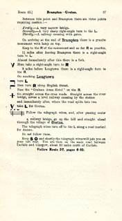 click to enlarge click to enlargeJS5097.jpg pp.93-97 in the road book, Roads Made Easy by Picture and Pen, vol.3. printed at beginning, p.93:- "ROUTE 43. / DONCASTER via Boroughbridge (43½), Scotch Corner (72½), Barnard Castle (85½), Middleton-in-Teesdale (96½), Alston (118½), Longtown (148½), Gretna (155¼), to GLASGOW (240½)." item:- private collection : 268.14 Image © see bottom of page |
|||
|
|
||||
| evidence:- | old itinerary:- Johnson 1908 (Roads/Cum) |
|||
| source data:- | Itinerary, Route 43 reverse in Roads Made Easy by Picture and Pen, Glasgow to Doncaster,
through Alston, by Claude Johnson, edited by Lord Montagu, published by The Car Illustrated,
168 Piccadilly, London, 1908.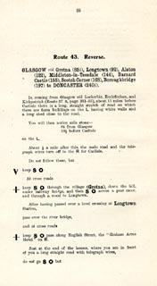 click to enlarge click to enlargeJS5098.jpg pp.98-106 in the road book, Roads Made Easy by Picture and Pen, vol.3. printed at beginning, p.98:- "ROUTE 43. Reverse. / GLASGOW via Gretna (85¼), Longtown (92), Alston (122), Middleton-in-Teesdale (144), Barnard Castle (155), Scotch Corner (168), Boroughbridge (197) to DONCASTER 240½)." item:- private collection : 268.15 Image © see bottom of page |
|||
|
|
||||
 Act of Parliament Act of Parliament |
||||
|
|
||||
| places:- |  Longtown Gretna, Scotland Longtown Gretna, Scotland |
|||
|
|
||||
| places:- |
|
|||
|
||||
|
||||
Lakes Guides menu.