Old Cumbria Gazetteer
 |
 |
|
||
| Penruddock | ||||
| civil parish:- | Hutton (formerly Cumberland) | |||
| county:- | Cumbria | |||
| locality type:- | locality | |||
| locality type:- | buildings | |||
| coordinates:- | NY42862766 (etc) | |||
| 1Km square:- | NY4227 | |||
| 10Km square:- | NY42 | |||
|
|
||||
| evidence:- | old map:- OS County Series (Cmd 58 9) placename:- Penruddock |
|||
| source data:- | Maps, County Series maps of Great Britain, scales 6 and 25
inches to 1 mile, published by the Ordnance Survey, Southampton,
Hampshire, from about 1863 to 1948. |
|||
|
|
||||
| evidence:- | old map:- Saxton 1579 placename:- Penrodok |
|||
| source data:- | Map, hand coloured engraving, Westmorlandiae et Cumberlandiae Comitatus ie Westmorland
and Cumberland, scale about 5 miles to 1 inch, by Christopher Saxton, London, engraved
by Augustinus Ryther, 1576, published 1579-1645.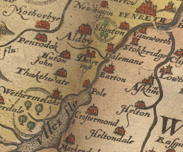 Sax9NY42.jpg Building, symbol for a hamlet, which may or may not have a nucleus. "Penrodok" item:- private collection : 2 Image © see bottom of page |
|||
|
|
||||
| evidence:- | old map:- Mercator 1595 (edn?) placename:- Penrodok |
|||
| source data:- | Map, hand coloured engraving, Northumbria, Cumberlandia, et
Dunelmensis Episcopatus, ie Northumberland, Cumberland and
Durham etc, scale about 6.5 miles to 1 inch, by Gerard Mercator,
Duisberg, Germany, about 1595.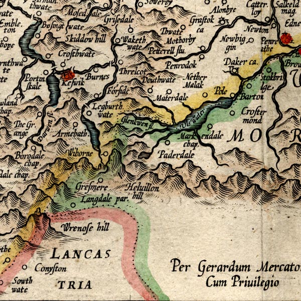 MER8CumF.jpg "Penrodok" circle item:- JandMN : 169 Image © see bottom of page |
|||
|
|
||||
| evidence:- | old map:- Speed 1611 (Cmd) placename:- Penrodok |
|||
| source data:- | Map, hand coloured engraving, Cumberland and the Ancient Citie
Carlile Described, scale about 4 miles to 1 inch, by John Speed,
1610, published by J Sudbury and George Humble, Popes Head
Alley, London, 1611-12.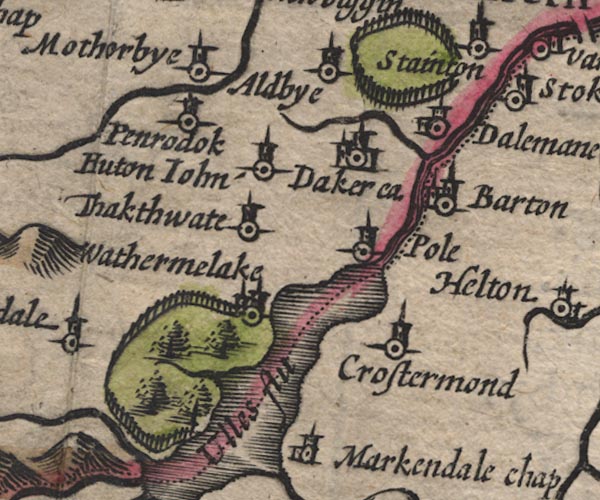 SP11NY42.jpg "Penrodok" circle, tower item:- private collection : 16 Image © see bottom of page |
|||
|
|
||||
| evidence:- | old map:- Jansson 1646 placename:- Penrodok |
|||
| source data:- | Map, hand coloured engraving, Cumbria and Westmoria, ie
Cumberland and Westmorland, scale about 3.5 miles to 1 inch, by
John Jansson, Amsterdam, Netherlands, 1646.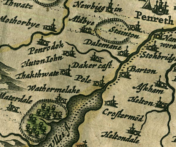 JAN3NY42.jpg "Penrodok" Buildings and tower. item:- JandMN : 88 Image © see bottom of page |
|||
|
|
||||
| evidence:- | old map:- Morden 1695 (Cmd) placename:- Penrodock |
|||
| source data:- | Map, uncoloured engraving, Cumberland, scale about 4 miles to 1
inch, by Robert Morden, 1695, published by Abel Swale, the
Unicorn, St Paul's Churchyard, Awnsham, and John Churchill, the
Black Swan, Paternoster Row, London, 1695-1715.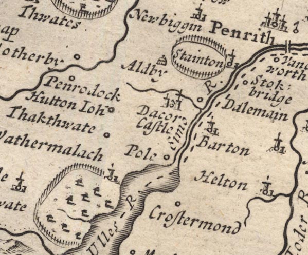 MD12NY42.jpg "Penrodock" Circle. item:- JandMN : 90 Image © see bottom of page |
|||
|
|
||||
| evidence:- | old map:- Bowen and Kitchin 1760 placename:- Penradock |
|||
| source data:- | Map, hand coloured engraving, A New Map of the Counties of
Cumberland and Westmoreland Divided into their Respective Wards,
scale about 4 miles to 1 inch, by Emanuel Bowen and Thomas
Kitchin et al, published by T Bowles, Robert Sayer, and John
Bowles, London, 1760.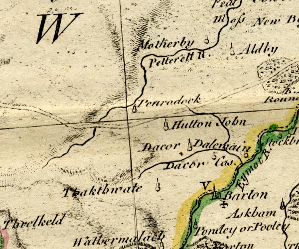 BO18NY32.jpg "Penradock" circle, tower item:- Armitt Library : 2008.14.10 Image © see bottom of page |
|||
|
|
||||
| evidence:- | old map:- Donald 1774 (Cmd) placename:- Penruddock |
|||
| source data:- | Map, hand coloured engraving, 3x2 sheets, The County of Cumberland, scale about 1
inch to 1 mile, by Thomas Donald, engraved and published by Joseph Hodskinson, 29
Arundel Street, Strand, London, 1774.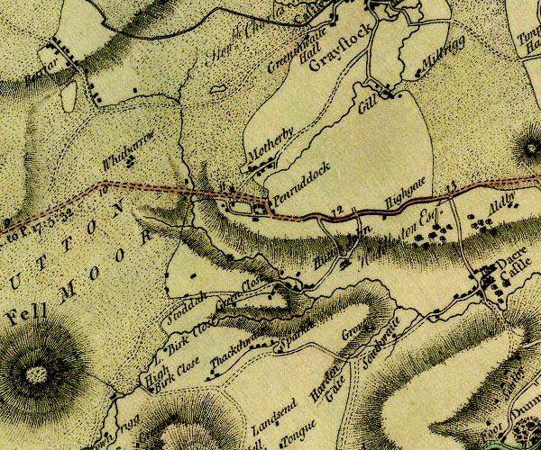 D4NY42NW.jpg "Penruddock" block or blocks, labelled in lowercase; a hamlet or just a house item:- Carlisle Library : Map 2 Image © Carlisle Library |
|||
|
|
||||
| evidence:- | descriptive text:- West 1778 (11th edn 1821) |
|||
| source data:- | Guide book, A Guide to the Lakes, by Thomas West, published by
William Pennington, Kendal, Cumbria once Westmorland, and in
London, 1778 to 1821. goto source goto sourceAddendum; Mr Gray's Journal, 1769 Page 202:- "..." "Oct. 2. I set out at ten for Keswick [from Penrith], ... passed through Penruddock and Threlkeld at the foot of Saddleback, ..." |
|||
|
|
||||
| evidence:- | old map:- West 1784 map placename:- Penruddock |
|||
| source data:- | Map, hand coloured engraving, A Map of the Lakes in Cumberland,
Westmorland and Lancashire, scale about 3.5 miles to 1 inch,
engraved by Paas, 53 Holborn, London, about 1784.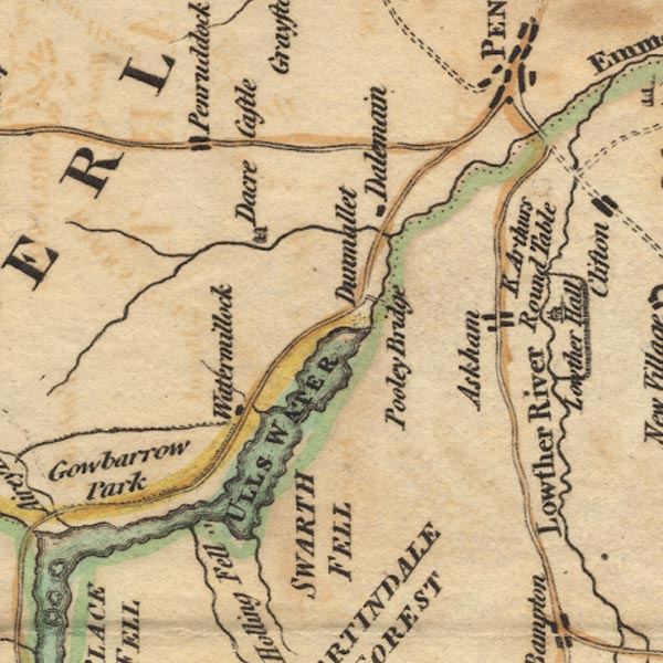 Ws02NY42.jpg item:- Armitt Library : A1221.1 Image © see bottom of page |
|||
|
|
||||
| evidence:- | old text:- Clarke 1787 placename:- Penruddock |
|||
| source data:- | Guide book, A Survey of the Lakes of Cumberland, Westmorland,
and Lancashire, written and published by James Clarke, Penrith,
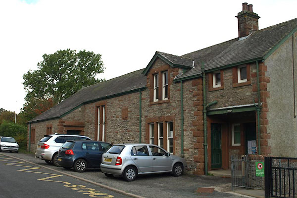
Cumberland, and in London etc, 1787; published 1787-93. goto source Page 50:- "..." "We next arrive at Penruddock, a long, dirty, straggling village, upon the edge of a common: their parish church is at Greystock, but they have a small Presbyterian meeting-house in the village." |
|||
|
|
||||
| evidence:- | road book:- Cary 1798 (2nd edn 1802) placename:- Penruddock |
|||
| source data:- | Road book, itineraries, Cary's New Itinerary, by John Cary, 181
Strand, London, 2nd edn 1802. goto source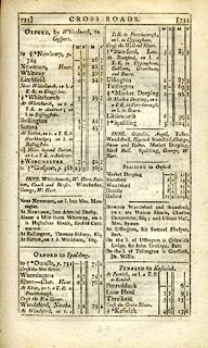 click to enlarge click to enlargeC38733.jpg page 733-734 "Penruddock" item:- JandMN : 228.2 Image © see bottom of page |
|||
|
|
||||
| evidence:- | old map:- Cooke 1802 placename:- Penruddock |
|||
| source data:- | Map, Cumberland, scale about 15.5 miles to 1 inch, by George
Cooke, 1802, bound in Gray's New Book of Roads, 1824, published
by Sherwood, Jones and Co, Paternoster Road, London, 1824. click to enlarge click to enlargeGRA1Cd.jpg "Penruddock" blocks, italic lowercase text, village, hamlet, locality item:- Hampshire Museums : FA2000.62.2 Image © see bottom of page |
|||
|
|
||||
| evidence:- | old map:- Laurie and Whittle 1806 placename:- Penruddock |
|||
| source data:- | Road map, Completion of the Roads to the Lakes, scale about 10
miles to 1 inch, by Nathaniel Coltman? 1806, published by Robert
H Laurie, 53 Fleet Street, London, 1834. click to enlarge click to enlargeLw18.jpg "Penruddock" village or other place item:- private collection : 18.18 Image © see bottom of page |
|||
|
|
||||
| evidence:- | old map:- Wallis 1810 (Cmd) placename:- Penruddock |
|||
| source data:- | Road map, hand coloured engraving, Cumberland, scale about 16
miles to 1 inch, by James Wallis, 77 Berwick Stree, Soho,
London, 1810. click to enlarge click to enlargeWL13.jpg "Penruddock" village, hamlet, house, ... item:- Dove Cottage : 2009.81.10 Image © see bottom of page |
|||
|
|
||||
| evidence:- | old map:- Otley 1818 placename:- Penruddock |
|||
| source data:- | Map, uncoloured engraving, The District of the Lakes,
Cumberland, Westmorland, and Lancashire, scale about 4 miles to
1 inch, by Jonathan Otley, 1818, engraved by J and G Menzies,
Edinburgh, Scotland, published by Jonathan Otley, Keswick,
Cumberland, et al, 1833.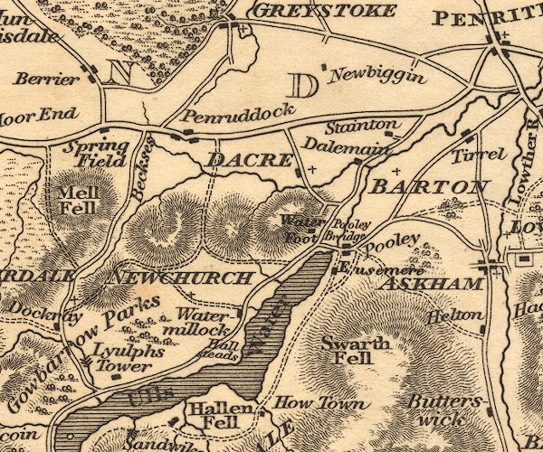 OT02NY42.jpg item:- JandMN : 48.1 Image © see bottom of page |
|||
|
|
||||
| evidence:- | old map:- Hall 1820 (Cmd) placename:- Penruddock |
|||
| source data:- | Map, hand coloured engraving, Cumberland, scale about 21 miles
to 1 inch, engraved by Sidney Hall, published by S Leigh, 18
Strand, London, 1820-31. click to enlarge click to enlargeHA14.jpg "Penruddock" circle, italic lowercase text; settlement item:- JandMN : 91 Image © see bottom of page |
|||
|
|
||||
| evidence:- | old map:- Ford 1839 map placename:- Penruddock |
|||
| source data:- | Map, uncoloured engraving, Map of the Lake District of
Cumberland, Westmoreland and Lancashire, scale about 3.5 miles
to 1 inch, published by Charles Thurnam, Carlisle, and by R
Groombridge, 5 Paternoster Row, London, 3rd edn 1843.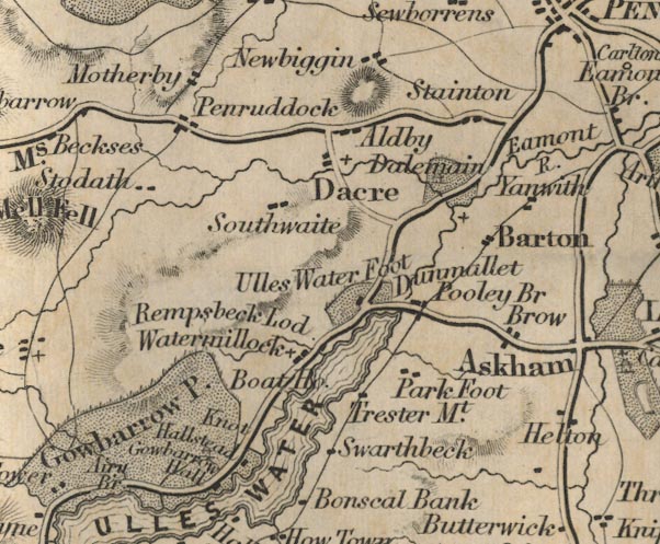 FD02NY42.jpg "Penruddock" item:- JandMN : 100.1 Image © see bottom of page |
|||
|
|
||||
| evidence:- | old map:- Garnett 1850s-60s H placename:- Penruddock |
|||
| source data:- | Map of the English Lakes, in Cumberland, Westmorland and
Lancashire, scale about 3.5 miles to 1 inch, published by John
Garnett, Windermere, Westmorland, 1850s-60s.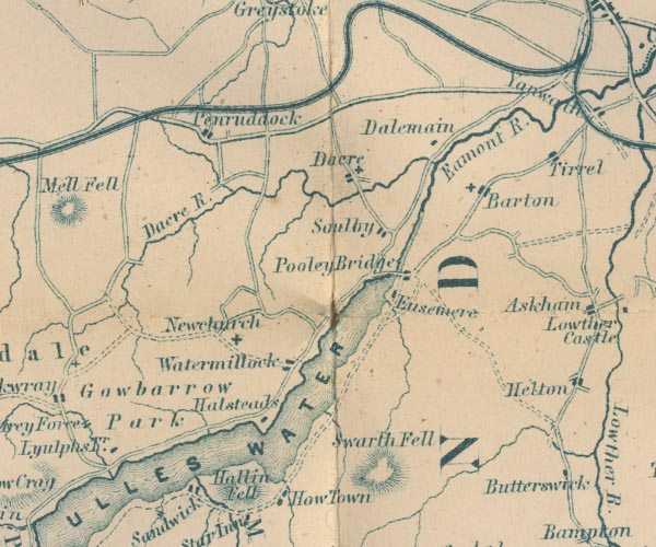 GAR2NY42.jpg "Penruddock" blocks, settlement item:- JandMN : 82.1 Image © see bottom of page |
|||
|
|
||||
| evidence:- | old map:- Post Office 1850s-1900s placename:- Penruddock |
|||
| source data:- | Post road maps, General Post Office Circulation Map for England
and Wales, for the General Post Office, London, 1850s-1900s. click to enlarge click to enlargePOF7Cm.jpg "Penruddock" map date 1909 |
|||
|
|
||||
| :- |
images courtesy of the British Postal Museum and Hampshire CC Museums |
|||
|
|
||||
| places:- |
|
|||
|
||||
|
||||
|
||||
|
||||
|
||||
|
||||
|
||||
|
||||
|
||||
|
||||
|
||||
|
||||
|
||||
|
||||
|
||||
|
||||
|
||||
|
||||
|
||||
|
||||
|
||||
Lakes Guides menu.