 Old Cumbria Gazetteer
 |
 |
|
|
| Newcastle and Carlisle Railway | |||
| NandCR | |||
| Carlisle and Newcastle Railway | |||
| civil parish:- | Carlisle (formerly Cumberland) | ||
| civil parish:- | Wetheral (formerly Cumberland) | ||
| civil parish:- | Hayton (formerly Cumberland) | ||
| civil parish:- | Brampton (formerly Cumberland) | ||
| civil parish:- | Nether Denton (formerly Cumberland) | ||
| civil parish:- | Upper Denton (formerly Cumberland) | ||
| county:- | Cumbria | ||
| locality type:- | railway | ||
| county:- | Northumberland | ||
| locality type:- | railway | ||
| SummaryText:- | from Newcastle on Tyne, via Haltwhistle and Greenhead, Northumberland; then Gilsland, Low Row, Naworth, Brampton, How Mill, Heads Nook, Wetheral, Scotby, to Carlisle, Cumberland. | ||
| references:- | 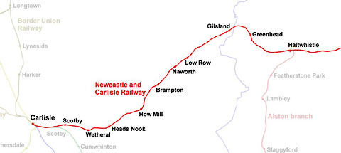 click to enlarge click to enlargeRWY002.jpg |
||
|
|
|||
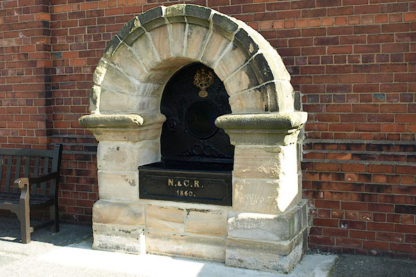 BPR08.jpg Water trough (from Blaydon Station):- "N. &C. R. / 1860" (taken 2008) courtesy of the National Railway Museum (NMR:1976-7049) 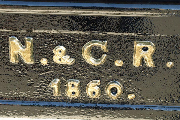 BPR09.jpg Water trough (from Blaydon Station):- "N. &C. R. / 1860" (taken 2008) courtesy of the National Railway Museum (NMR:1976-7049) |
|||
|
|
|||
| evidence:- | descriptive text:- Ford 1839 (3rd edn 1843) placename:- Newcastle and Carlisle Railway |
||
| source data:- | Guide book, A Description of Scenery in the Lake District, by
Rev William Ford, published by Charles Thurnam, Carlisle, by W
Edwards, 12 Ave Maria Lane, Charles Tilt, Fleet Street, William
Smith, 113 Fleet Street, London, by Currie and Bowman,
Newcastle, by Bancks and Co, Manchester, by Oliver and Boyd,
Edinburgh, and by Sinclair, Dumfries, 1839. goto source goto sourcePage 107:- "... mails daily leave the city for Portpatrick and Belfast, Glasgow, Edinburgh, and London by way of Leeds and Manchester; besides several other stage-coaches. The Newcastle and Carlisle Railway offers opportunities four times a-day of travelling between those places; ..." |
||
|
|
|||
| evidence:- | old map:- Ford 1839 map |
||
| source data:- | Map, uncoloured engraving, Map of the Lake District of
Cumberland, Westmoreland and Lancashire, scale about 3.5 miles
to 1 inch, published by Charles Thurnam, Carlisle, and by R
Groombridge, 5 Paternoster Row, London, 3rd edn 1843.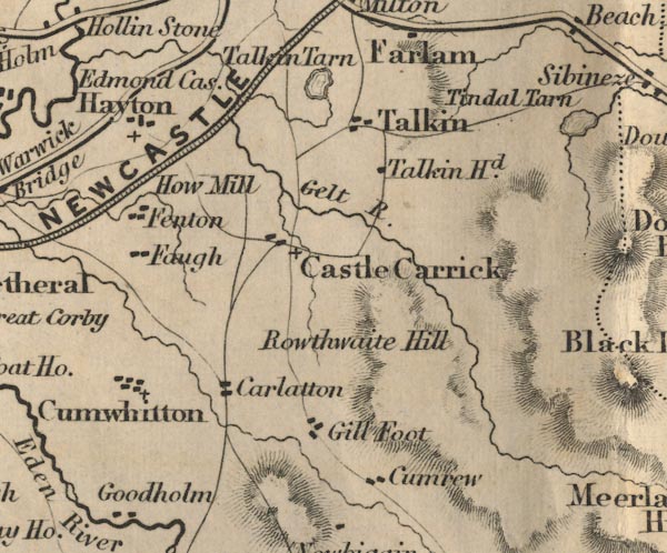 FD02NY55.jpg item:- JandMN : 100.1 Image © see bottom of page |
||
|
|
|||
| evidence:- | old map:- Ford 1839 map |
||
| source data:- | Map, uncoloured engraving, Map of the Lake District of
Cumberland, Westmoreland and Lancashire, scale about 3.5 miles
to 1 inch, published by Charles Thurnam, Carlisle, and by R
Groombridge, 5 Paternoster Row, London, 3rd edn 1843.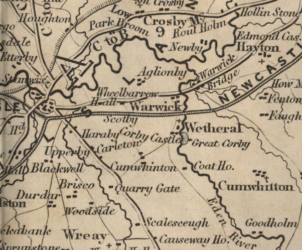 FD02NY45.jpg item:- JandMN : 100.1 Image © see bottom of page |
||
|
|
|||
| evidence:- | old map:- Ford 1839 map |
||
| source data:- | Map, uncoloured engraving, Map of the Lake District of
Cumberland, Westmoreland and Lancashire, scale about 3.5 miles
to 1 inch, published by Charles Thurnam, Carlisle, and by R
Groombridge, 5 Paternoster Row, London, 3rd edn 1843.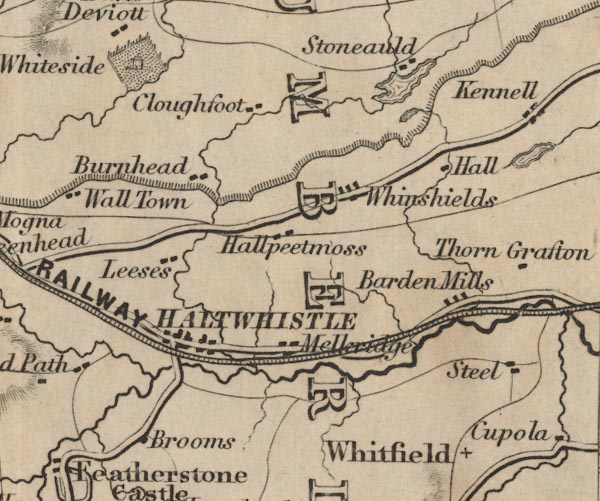 FD02NY76.jpg item:- JandMN : 100.1 Image © see bottom of page |
||
|
|
|||
| evidence:- | old map:- Ford 1839 map |
||
| source data:- | Map, uncoloured engraving, Map of the Lake District of
Cumberland, Westmoreland and Lancashire, scale about 3.5 miles
to 1 inch, published by Charles Thurnam, Carlisle, and by R
Groombridge, 5 Paternoster Row, London, 3rd edn 1843.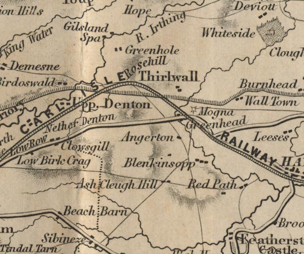 FD02NY66.jpg item:- JandMN : 100.1 Image © see bottom of page |
||
|
|
|||
| evidence:- | old map:- Ford 1839 map placename:- Newcastle and Carlisle Railway |
||
| source data:- | Map, uncoloured engraving, Map of the Lake District of
Cumberland, Westmoreland and Lancashire, scale about 3.5 miles
to 1 inch, published by Charles Thurnam, Carlisle, and by R
Groombridge, 5 Paternoster Row, London, 3rd edn 1843.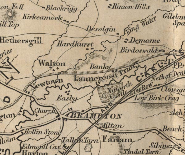 FD02NY56.jpg "NEWCASTLE AND CARLISLE RAILWAY" item:- JandMN : 100.1 Image © see bottom of page |
||
|
|
|||
| evidence:- | old text:- |
||
| source data:- | : 1841: Bradshaw's Railway Companion: Bradshaw and Blacklock (Manchester, Lancashire)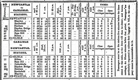 click to enlarge click to enlargeBRA1NC.jpg |
||
|
|
|||
| evidence:- | old map:- Garnett 1850s-60s H placename:- Newcastle and Carlisle Railway |
||
| source data:- | Map of the English Lakes, in Cumberland, Westmorland and
Lancashire, scale about 3.5 miles to 1 inch, published by John
Garnett, Windermere, Westmorland, 1850s-60s.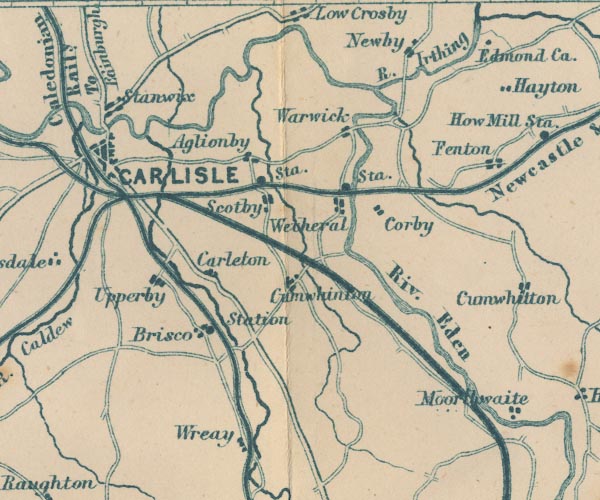 GAR2NY45.jpg triple line, light bold light, railway 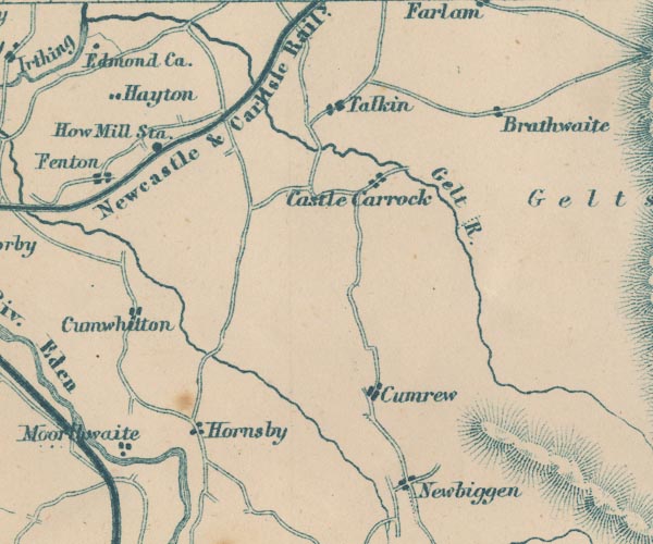 GAR2NY55.jpg "Newcastle &Carlisle Raily." item:- JandMN : 82.1 Image © see bottom of page |
||
|
|
|||
| evidence:- | old map:- North Eastern Railway c1900 placename:- North Eastern Railway |
||
| source data:- | Railway map, wall map of coloured ceramic tiles, North Eastern
Railway, scale about 2.5 miles to 1 inch, made by Craven,
Dunnill and Co, Jackfield, Shropshire, about 1900.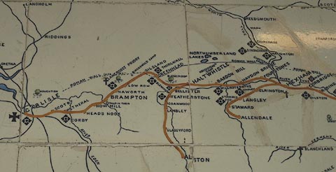 click to enlarge click to enlargeNER1R1.jpg item:- National Railway Museum : 1995-7786 Image © see bottom of page |
||
|
|
|||
| hearsay:- |
A narrow gauge railway, the South Tynedale Railway, now uses the trackbed of the branch
to Alston. |
||
|
|
|||
| person:- | railway company : Newcastle and Carlisle Railway |
||
| date:- | 1829 to 1862 |
||
|
|
|||
| person:- | railway company : North Eastern Railway; NER |
||
| date:- | 1862 to 1923 |
||
|
|
|||
| person:- | railway company : London and North Eastern Railway; LNER |
||
| date:- | 1923 to 1948 |
||
|
|
|||
| person:- | railway company : British Railways; BR |
||
| date:- | 1948 |
||
|
|
|||
| also see:- | Alston branch railway |
||
|
|
|||
| goes through:- | [Newcastle Central Station, Northumberland] Haltwhistle Junction, Haltwhistle Haltwhistle Station, Haltwhistle Greenhead Station, Northumberland Rose Hill Station, Gilsland railway bridge, Gilsland Denton School Level Crossing, Upper Denton accommodation crossing, Upper Denton Denton Village Level Crossing, Upper Denton Upper Denton Level Crossing, Upper Denton [Lane Head Crossing, Nether Denton] signal box, Low Row Low Row Station, Low Row Low Row Level Crossing, Low Row[railway bridge, Brampton (2)] [level crossing, Naworth] Naworth Station, Brampton level crossing, Milton Brampton Junction, Brampton Brampton Junction Station, Brampton railway bridge, Bramptonfell level crossing, Brampton Brampton Fell Station, Brampton Gelt Bridge, Hayton railway bridge, Hayton (2) Cowran Cutting, Hayton railway bridge, Hayton How Mill Station, How railway milepost, How Fenton Embankment, Fenton railway bridge, Fenton railway bridge, Heads Nook Heads Nook Station, Heads Nook[level crossing, Broadwath] railway crossing, Great Corby Glenwillie Bridge, Great Corby coal depot, Great Corby signal box, Great Corby Corby Gates, Great Corby Corby Bridge, Wetheral Wetheral Station, Wetheral railway bridge, Wetheral (2) railway milepost, Wetheral railway bridge, Scotby (3) Scotby Embankment, Scotby railway bridge, Scotby Scotby Station, Scotby[railway bridge, Scotby (6)] Durranhill Bridge, Carlisle[Durranhill Sidings, Carlisle] Petteril Bridge Junction, Carlisle[railway bridge, Carlisle (9)] engine shed, Carlisle (11) engine shed, Carlisle (13) Harraby Cutting, Carlisle engine shed, Carlisle (12) London Road Terminus, Carlisle London Road Goods Depot, Carlisle London Road Tunnel, Harraby London Road East Junction, Carlisle London Road West Junction, Carlisle St Nicholas Bridges, Carlisle Carlisle Citadel Station, Carlisle22.5.1829: authorized - 1836: opened - |
||
|
|
|||
| goes through:- | London Road West Junction, Carlisle St Nicholas Bridges, Carlisle railway bridge, Carlisle (2) [railway bridge, Carlisle (8)] [railway bridge, Carlisle (5)] [railway bridge, Carlisle (4)] railway bridge, Carlisle (7)[railway bridge, Carlisle (6)] engine shed, Carlisle (8) Canal Junction S, Carlisle |
||
|
|
|||
Lakes Guides menu.