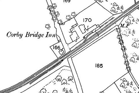


 click to enlarge
CSRY0207.jpg
 Old Cumbria Gazetteer
 |
 |
   |
| coal depot, Great Corby | ||
| site name:- | Newcastle and Carlisle Railway | |
| locality:- | Corby Crossing | |
| locality:- | Great Corby | |
| civil parish:- | Wetheral (formerly Cumberland) | |
| county:- | Cumbria | |
| locality type:- | coal depot | |
| coordinates:- | NY47175480 (about) | |
| coordinates:- | NY47105473 (roughly) | |
| 1Km square:- | NY4754 | |
| 10Km square:- | NY45 | |
| SummaryText:- | Two sets of sidings accessed by facing points off up and down line, either side of the crossing. | |
|
|
||
| evidence:- | old map:- OS County Series (Cmd 24 6) |
|
| source data:- | Maps, County Series maps of Great Britain, scales 6 and 25
inches to 1 mile, published by the Ordnance Survey, Southampton,
Hampshire, from about 1863 to 1948. click to enlarge click to enlargeCSRY0207.jpg |
|
|
|
||
| hearsay:- |
The coal depot was built for the Earl of Carlisle. The points were operated by his
employe, in 1836 this was John Rowlandson, not supervised by the railway. |
|
| In December 1836 the points were not reset after shunting: locomotive Samson and a
mixed train, goods wagons and carriages with 26 passengers, slowing and approaching
Wetheral, was diverted into the west siding. The driver spotted the setting of the
points, put the engine into reverse, applied the brakes, and leapt off with the fireman.
The train demolished standing wagons and the depot. The coaches at the rear stayed
on the track and passenger injuries were minor; a man standing on the depot was killed,
and so were two boys riding illegally under the tarpaulin of a grain wagon. |
||
| :1836 (10 Dec):: CarlisleJournal |
||
|
|
||
 Lakes Guides menu.