 Old Cumbria Gazetteer
 |
 |
|
||||||||||||||||||||||||||||||||||||||||||||||||||||||||||||||||
| Ingleborough, North Yorkshire | ||||||||||||||||||||||||||||||||||||||||||||||||||||||||||||||||||
| Ingleborough | ||||||||||||||||||||||||||||||||||||||||||||||||||||||||||||||||||
| Ingleborough Hill | ||||||||||||||||||||||||||||||||||||||||||||||||||||||||||||||||||
| county:- | North Yorkshire | |||||||||||||||||||||||||||||||||||||||||||||||||||||||||||||||||
| locality type:- | hill | |||||||||||||||||||||||||||||||||||||||||||||||||||||||||||||||||
| coordinates:- | SD74127458 | |||||||||||||||||||||||||||||||||||||||||||||||||||||||||||||||||
| 1Km square:- | SD7474 | |||||||||||||||||||||||||||||||||||||||||||||||||||||||||||||||||
| 10Km square:- | SD77 | |||||||||||||||||||||||||||||||||||||||||||||||||||||||||||||||||
| altitude:- | 2375 feet | |||||||||||||||||||||||||||||||||||||||||||||||||||||||||||||||||
| altitude:- | 724m | |||||||||||||||||||||||||||||||||||||||||||||||||||||||||||||||||
|
|
||||||||||||||||||||||||||||||||||||||||||||||||||||||||||||||||||
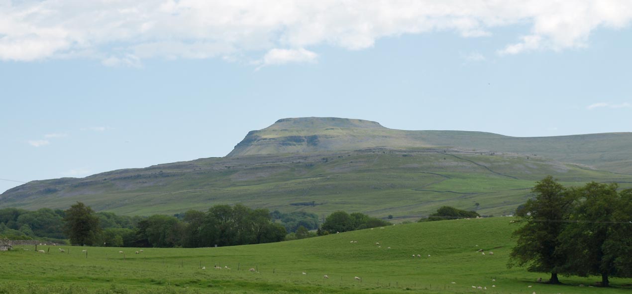 Click to enlarge BUU75.jpg (taken 26.6.2011) |
||||||||||||||||||||||||||||||||||||||||||||||||||||||||||||||||||
|
|
||||||||||||||||||||||||||||||||||||||||||||||||||||||||||||||||||
| evidence:- | old map:- Saxton 1579 |
|||||||||||||||||||||||||||||||||||||||||||||||||||||||||||||||||
| source data:- | Map, hand coloured engraving, Westmorlandiae et Cumberlandiae Comitatus ie Westmorland
and Cumberland, scale about 5 miles to 1 inch, by Christopher Saxton, London, engraved
by Augustinus Ryther, 1576, published 1579-1645.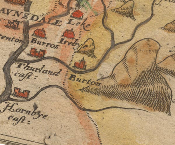 Sax9SD67.jpg item:- private collection : 2 Image © see bottom of page |
|||||||||||||||||||||||||||||||||||||||||||||||||||||||||||||||||
|
|
||||||||||||||||||||||||||||||||||||||||||||||||||||||||||||||||||
| evidence:- | old text:- Gents Mag |
|||||||||||||||||||||||||||||||||||||||||||||||||||||||||||||||||
| source data:- | Magazine, The Gentleman's Magazine or Monthly Intelligencer or
Historical Chronicle, published by Edward Cave under the
pseudonym Sylvanus Urban, and by other publishers, London,
monthly from 1731 to 1922. goto source goto sourceGentleman's Magazine 1761 p.126 "Mr URBAN," "I Have long been an attentive reader of your Magazine, and have been particulary pleased with that part of your work, in which the natural curiosities of remarkable places are described. In your Mag. for July last, (See p.316) a correspndent from Wakefield expresses a desire that some person who resides near Ingleborough in Yorkshire, would communicate to the public an account of the uncommon curiosities which are found in the environs of that place. As you have yet published nothing on the subject, I send you the following account, and hope ot will at least excite some more able hand to send you a better." "INGLEBOROUGH is situated in the west riding of the county of York; the westerly and northerly part of it lies in the parish of Bentham; the easterly in the parish of Horton in Pibbledale (sic); the southerly in the parish of Clapham. It is likewise a part of four manors. The manor of Ingleton, to the west; belonging to ----- Parker, Esq; the manor of Newby, to the co-heirs of the late duke of Montagu; the manor of Clapham, to Josias Morley, Esq; and the manor of Austwick, to James Shuttleworth, Esq. It is a mountain, singularly eminent, whether you regard its height, or the immediate base upon which it stands. It is near 20 miles in circumference, and has Clapham, a church town, to the south; Ingleton to the west; Chapel in the Dale to the north; and Selside, a small hamlet, to the east; from each of which places the rsie, in some parts, is even and gradual; in others, rugged and perpendicular. In this mountain rise considerable streams, which at length fall into the Irish Sea. The land round the bottom is fine fruitful pasture, interspersed with many acres of lime-stone rocks. As you ascend the mountain, the land is more barren, and under the surface is peat-moss, in many places two or three yards deep, which the country people cut up, and dry for burning, instead of coal. As the mountain rises, it becomes more rugged and perpendicular, and is" |
|||||||||||||||||||||||||||||||||||||||||||||||||||||||||||||||||
|
|
||||||||||||||||||||||||||||||||||||||||||||||||||||||||||||||||||
| evidence:- | old text:- Gents Mag 1761 item:- pothole; Noah's Flood |
|||||||||||||||||||||||||||||||||||||||||||||||||||||||||||||||||
| source data:- | goto source Gentleman's Magazine 1761 p.127 "at length so steep that it cannot be ascended without great difficulty, and in some places not at all. In many parts there are fine quarries of slate, which the neighbouring inhabitants use to cover their houses, but no lime-stones; yet, near the base, no stones but lime-stones are to be found. The loose stones near the summit the people call greet stone. The foot of the mountain abounds with fine springs on every side, and on the west side there is a very remarkable spring near the summit. The top is very level, but so dry and barren that it affords little grass, the rock being but barely covered with earth. It is said to be about a mile in circumference, and several persons now living say, that they have seen races upon it. Upon that part of the top, facing Lancaster and the Irish Sea, there are still to be seen the dimensions of an house, and the remains of what the country people call a beacon, viz. a place erected with stones, three or four yards high, ascended with stone stairs; which served in old time, as old people tell us, to alarm the country, upon the approach of an enemy, a person always being kept there upon watch, in the time of war, who was to give notice in the night, by fire, to other watchmen placed upon other mountains within view, of which there are many, particularly Whernside, Woefall, Camfell, Pennygent, and Pennlehill. There are likewise discoverable a great many other mountains in Westmoreland and Cumberland, besides the town of Lancaster, from which it is distant about 20 miles." "The west and north sides are most steep and rocky; there is, one part to the south, where you may ascend on horseback; but whether the work of nature, or of art, I cannot say. A part of the said mountain jutts out to the north east near a mile, but somewhat below the summit; this part is called Park-fell; another part jutts out in the same manner, near a mile, towards the east,and is called Simon-fell; there is likewise another part towards the south, called Little Ingleborough; the summits of all which are much lower than the top of the mountain itself." "Near the base, there are holes or chasms called swallows, supposed to be the remains of Noah's deluge; they are among the lime-stone rocks, and are open to an incredible depth. The springs towards the east all come together, and fall into one of these swallows, or holes, called Allan Pott; and after passing under the earth about a mile, thay burst out again, and flow into the river Ribble, whose head, or spring, is but a little further up the valley. The depth of this swallow, or hole, could never be ascertained; it is about 20 poles in circumference, not perfectly circular, but rather oval. In wet foggy weather, it sends out a smoak, or mist, which may be seen a considerable distance. Not far from this hole, nearly north, is another hole, which may be easily descended. In some places the roof is 4 or 5 yards high, and its width is the same; in other places not above a yard; and was it not for the run of water, it is not to be known how far you might walk, by the help of a candle, or other light. There is likewise another hole, or chasm, a little west from the other two, which cannot be descended without difficulty: You are no sooner entered than you have a subterraneous passage, sometimes wide and spacious, sometimes so narrow you are obliged to make use of both hands, as well as feet, to crawl a considerable way; and as I was informed, some persons have gone several hundred yards, and might have gone much further, durst they have ventured. There are a great many more holes, or caverns, well worth the notice of a traveller: some dry, some having a continual run of water; such as Blackside Cove, Sir William's Cove, Atkinson's Chamber, &c. all whose curiosities are more than I can describe." "There is likewise, partly south-east, a small rivulet, which falls into a place considerably deep, called Long-Kin; there is likewise another swallow, or hole, called Johnson's Jacket-hole,a place resembling a funnel in shape, but vastly deep; a stone being thrown into it, makes a rumbling noise, and may be heard a considerable time; there is also another, called Gaper-Gill, into which a good many springs fall in one stream, and after a subterraneous passage of upwards of a mile, break out again, and wind thro' Clapham; then afterwards a winding course of several miles, this stream joins the river Lon, or Lune; and, passing by the town of Lancaster, it falls into the Irish Sea: There likewise, both on the west and north sides, a great many springs, which all fall into such cavities, and bursting out again, towards the base of the said mountain, fall likewise into the Irish Sea, by the town of Lancaster; and what seemed very remarkable to me, there was not one rivulet running from" |
|||||||||||||||||||||||||||||||||||||||||||||||||||||||||||||||||
|
|
||||||||||||||||||||||||||||||||||||||||||||||||||||||||||||||||||
| evidence:- | old text:- Gents Mag 1761 item:- greet stones |
|||||||||||||||||||||||||||||||||||||||||||||||||||||||||||||||||
| source data:- | goto source Gentleman's Magazine 1761 p.128 "the base of the mountain that had not a considerable subterraneous passage. All the springs arose towards the summit, amongst the greet-stones and sunk or fell into some hole, as soon as they descended to the lime-stone rocks; where passing under ground for some way, they burst out again towards the base. There is likewise, to the west and north, a great many swallows or holes, some vastly deep and frightful, others more shallow, all astonishing, with a long range of the most beautiful rocks that ever adorned a prospect, rising in a manner perpendicularly up to an immense height." "In the valley above Horton, near the base of this mountain, I observed a large heap or pile of greet-stones all thrown promiscuously together, without any appearance of building or workmanship, which yet cannot be reasonably thought to be the work of nature; few stones are to be found near it, though 'tis computed to contain 400 of that country cart load of stones, or upwards. There is liekwise another at the base north-east, in resemblance much the same, but scarce so large, and I was informed of several others up and down the country. Now if any of your correspondents will favour me with their thoughts how, and upon what account, they have been laid there, they will highly oblige your humble servant, and constant reader," "PASTOR." |
|||||||||||||||||||||||||||||||||||||||||||||||||||||||||||||||||
|
|
||||||||||||||||||||||||||||||||||||||||||||||||||||||||||||||||||
| evidence:- | old text:- Pennant 1773 placename:- Ingleborough item:- caves; Ingleborough, altitude; placename, Ingleborough |
|||||||||||||||||||||||||||||||||||||||||||||||||||||||||||||||||
| source data:- | Book, A Tour from Downing to Alston Moor, 1773, by Thomas
Pennant, published by Edward Harding, 98 Pall Mall, London, 1801. goto source Pennant's Tour 1773, page 114 "I descended to Ingleton, a small town and chapelry in the parish of Bentham, seated at the foot of the great mountain of Ingleborough, which looks like Ossa upon Pelion, and is well described by Camden, as stretching with its vast back rising towards the west, with another hill, as if flung upon its extremity. I had not leisure to visit it; but was informed that it was well worth a traveller's attention, on account of the immense caverns it abounds with, and the various plants very rare in other places. This is reckoned the highest ground in England in respect to the sea, and I believe with truth. Its situation is pretty central, and its cumulated acquisition of height very great. - Its name shews its pre-eminence - Ingleborough, the borough, berg or hill of England. Several rivers arise within this chain, which take their courses into different seas: the Lune and the Ribble flow into the western; the Wharf, the Ure, and the Nid, into the eastern sea." "Among the plants the Botanist will find that pigmy willow the Salix herbacea, Fl. Sc. 11, 600; and the S. reticulata, or Wrinkled Willow, 601. The sweet plant the Rhodiola rosea, or Rosewort, Fl. Sc. 11, 619, grows here; useful to the Greenlanders, for food; to the natives of the Feroe Isles, in the scurvy; the fresh roots, applied in form of a cataplasm, are said to relieve the headach, and to heal ma-" goto sourcePennant's Tour 1773, page 115 "[ma]lignant ulcers: a water, fragrant as that of roses, may be distilled from them. Those elegant plants the saxifraga oppositifolia and autumnalis, Fl. Sc. 1, 222, are to be met with here; and the Actaea spicata, spoken of before." "My friend met with, here, the Epilobium angustifolium, or Rosebay Willow Herb, Fl. Sc. 1, 196, a flowering plant worthy of our gardens. We have of late discovered that the down of the seeds has been manufactured with cotton, or beaver's hair, into stockings, filletting, bindings, &c. The down is obtained by drying the seed-vessels in an oven, then thrashing and riddling the seeds from the down, which is carded with the cotton or fur. The beastly Kamtschadales brew a sort of ale from the pith, and have invented an intoxicating liquor from the infusion of the leaves; they also eat the young shoots which trail beneath the ground." "To these plants I must add the Ophrys cordata, or Heart-shaped Tway-blade, Fl. Sc. 1, 524; the Sedum villosum or Marsh Stonecrop, Fl. Sc. 1, 237; and the Lichen aphtosus, or Green-ground Liverwort, Fl. Sc. 11, 848. It takes its trivial name from the use made of it by the people of Uplaed in Sweden, who, in cases of the aptha or thrush in children, give them an infusion of this plant in milk. A de-" goto sourcePennant's Tour 1773, page 116 "[de]coction of it in water is besides used in Sweden, which operates as a purge and vomit, and is efficacious in worm complaints." "The Lycopodium alpinum, and Selago, Fl. Sc. 11, 687, 690, are common amidst these hills: the last is a most valuable plant in the northern regions. The Swedes make of it coarse mats: the Russians use the powder of the capsules to heal galls in children, chopped skins, or other sores: the Poles, with a decoction of it, foment the heads of those afflicted with the filthy disorder of their country, the Plica polonica, and, as is said, effect the cure." "It is observed that the capsules emit a yellow powder, which flashes with a small explosion at the flame of a candle. Even this has been turned to use, and serves to make artificial lightening at theatrical entertainments." "..." |
|||||||||||||||||||||||||||||||||||||||||||||||||||||||||||||||||
|
|
||||||||||||||||||||||||||||||||||||||||||||||||||||||||||||||||||
| evidence:- | descriptive text:- West 1778 (11th edn 1821) |
|||||||||||||||||||||||||||||||||||||||||||||||||||||||||||||||||
| source data:- | Guide book, A Guide to the Lakes, by Thomas West, published by
William Pennington, Kendal, Cumbria once Westmorland, and in
London, 1778 to 1821. goto source Addendum; Mr Gray's Journal, 1769 Page 219:- "..." "From the leads of the tower [Hornby Castle] ... Ingleborough, which I had seen before distinctly at Lancaster to north-east, was completely wrapped in clouds, all but its summit; which might have easily been mistaken for a long black cloud too, fraught with an approaching storm. ... ... Ingleton, ... is a pretty village, situate very high, and yet in a valley, at the foot of that huge monster of nature, Ingleborough: ..." goto sourcePage 221:- "..." "Oct. 14. Leaving [Settle] ... I saw at once the three famous hills of this county, Ingleborough, Pennygant, and Pendle; the first is esteemed the highest, and their features are not to be described, but by the pencil." goto sourceTour to the Caves in the West Riding of Yorkshire, late 18th century Page 241:- "... Ingleborough, whose head was wrapt in a cloud, stood the farthest to the south in the rank of the mountains which faced us. ... [from Kirkby Lonsdale]" goto sourcePage 251:- "..." "If the tourist would proceed immediately to Chapel-in-the-Dale, ... which will lead him, by some houses, down to the chapel, in the middle of the vale between Whernside and Ingleborough." goto sourcePage 253:- "[at Ingleton] ... The church-yard, ... commands a fine view of the vale of Lonsdale, ... On the back-ground are the lofty mountains of Gragareth, Whernside, and Ingleborough, the summits of which, when they are not enveloped in the clouds, can scarcely be seen for their high intervening bases. When the top of Ingleborough is covered with a thick white mist (or, as the country people say, when he puts on his night-cap) there are often strong gusts, called helm winds, blowing from thence to that part of the country which adjoins to its base. The like observation is made, by the mariners, of the table-land of the Cape of Good Hope, on the coast of Africa. They are called helm winds, from their blowing from the cloud or helmet that covers the head of the mountains.- ... [2]" "[2] The writer of this Tour to the Caves was informed of a deep and curious chasm on the western extremity of the base of Ingleborough, about the village of Caldecoates, about a mile or two from Ingleton; but as he did not see it himself, he has not attempted a description of it from tradition." goto sourcePage 261:- "..." "... proceeded [from Weathercoat cave] to another, called Douk-Cove, about a mile south, on the other side of the turnpike road, towards the foot of Ingleborough, whose height now appeared to great advantage from the nature of our own elevated situation. ..." goto sourcePage 262:- "We were now on the base on which Ingleborough stands, [1] and greatly elevated above all the western country. Our distance from the bottom, where the steep ascent of this high mountain begins, was about a mile, in a direct horizontal line over rocks and pits. The fineness and clearness of the day, however, induced us to ascend its side, and gain its summit. Though we had many a weary and slippery step, we thought ourselves amply repaid, when we got to the top, with the amusement we received in viewing the several extensive and diversified prospects, and in making our observations, as botanists and natural historians, on its productions and contents. All the country betwixt us and the sea, to the extent of forty, fifty, and sixty miles, from the north-west, by the west, to the south-west, lay stretched out beneath us, like a large map, with the roads, rivers, villages, towns, seats, hills and vales, capes and bays, in succession. Elevation is a great leveller; all the hills and little mountains in the country before us, appeared sunk in our eyes, and in the same plain with the adjacent meadows. To the north-west, the prospect was terminated, at the distance of forty or fifty miles, by a chain of rugged mountains in Westmorland, Lancashire, and Cumberland, which appeared as barriers against the fury of the ocean. To the west, the Irish Sea extends as far as the eye can penetrate, except where the uniformity of the watery prospect is interrupted by the isles of Man and Anglesey. The blue mountains in Wales terminated our further progress, after we had traced out the winding of the coast all the way from Lancaster, by Preston and Liverpool. A curious deceptio visus presented itself: all the vales between us and the sea appeared lower than its surface, owing to the sky and earth both apparently tending to a line drawn from the eye parallel to the horizon, where they at last appeared to meet. To the east and north, the prospect was soon" "[1] The word Ingleborough seems to be derived from the Saxon word ingle, which signifies a lighted fire; and borough, or burgh, which comes originally from the Greek word purgos, and signifies a watch tower (the labials p and b being often changed into each other) for here a beacon is erected, on which a fire used to be made for a signal of alarm in times of rebellion or invasion." goto sourcePage 263:- "terminated by a number of black, irregular, chaotic mountains; which, by their indentations and winding summits, gave us reason to believe they contained habitable vales between them. Their sides afford a hardy and wholesome pasture for sheep, and their bowels contain rich mines of lead, some of which are wrought with great advantage to the proprietors." "The immense base on which Ingleborough stands, is between twenty and thirty miles in circumference. The rise is in some places even and gradual; and in others, as to the north and west, it is rugged, and almost perpendicular. The top is plain and horizontal, being almost a mile round, having the ruins of an old wall about it, from which some ingenious antiquaries endeavour to prove it has once been a Roman station, and place of great defence. Of late years it has never been frequented by any, except shepherds, and the curious-in-prospects, and the neighbouring country people, who resorted to the horse races, which were formerly annually held on its top. On the western edge there are the remains of what the country people call the beacon, some three or four yards high, ascended by a flight of steps. The ruins of a little watch-house is also adjoining. No doubt, in time of wars, insurrections, and tumults, and particularly during the incursions of the Scots, a fire was made on this beacon, to give the alarm to the country round about.- The soil on the top is so dry and barren, that it affords little grass, the rock being barely covered with earth: a spongy moss is all the vegetable that thrives in this lofty region. The stones on the summit, and for a great way down, are of the sandy gritty sort, with freestone slate amongst them: upon the base the rocks are all limestone, to an enormous depth. Near the top indeed, on the east side, is a stratum of limestone, like the Derbyshire marble, full of entrochi. Several springs have their origin near the summit, particularly one on the north side, of pure and well-tasted water, called Fair-weather Sykes, which runs down by the side of a sheep-fence wall into a chasm called Meir Gill. All the other springs, as well as this, when they come to the limestone base, are swallowed" goto sourcePage 264:- "up, and after running perhaps a mile underground, make their appearance once again in the surrounding vales, and then wind in various courses to the Lune or the Ribble, which empty themselves into the Irish Sea." "A naturalist cannot but observe a number of conical holes, with their vertexes downwards, not only all over the base of Ingleborough, but particularly a row near the summit. They are from two to four or five yards in diameter, and from two to three or four yards deep, except Barefoot-wives-hole (hereafter-mentioned) which is much larger. They resemble those pits about Mount AEtna, Vesuvius, and the various parts of Sicily and Calabria, as described by Hamilton and other writers. What may have been the cause of them, is left for the determination of the ingenious naturalist." "The other stones and fossils on and about Ingleborough, are black and brown marbles, abounding with white sea-shells, sparks of spar, and flakes of entrochi; spars of various sorts, the stalactical and icicle in the caves; slates, pale and brown, and near Ingleton blue; black shiver, Tripoli or rotten stone, blood stone, and lead ore. The soil on the base and sides of Ingleborough (where there is any) is chiefly peat-moss, which the country people get up and burn for fuel: the cover is in general ling or heath: other vegetables are ferns of various kinds; reindeer moss, and various other mosses: heleborines, white and red; the different sorts of sedums, crane's bills, scurvy-grass. bird's-eyes, various liver-worts, orchises, rose-wort, lily of the valley, mountain columbines, the hurtle-berry or bill-berry, knout-berry, cran-berry, cloud-berry, and cow-berry. The shrubs are mountain-vine, bird-cherry, mountain-ash, gelder-rose, burnet-rose, stone-bramble, red and black-currants. In the Foal-foot, which is the north-west corner of this mountain, are found the vivaperous-grass, and the rose-of-the-root, which has a yellow flower, and is like house-leek. Near Ingleton, as was before observed, are the lady's-slipper and fly-orchis. The chief animals found on and about Ingle-" goto sourcePage 265:- "[Ingle]borough, are grouse, the ring-ousle, and wheat-ear, the fox, mountain cat, wild-cat, pole-cat, weasle (sic), stoat, badger, and martin." "The perpendicular height of this mountain above the level of the sea, is 3987 feet, as taken by a neighbouring country-gentleman. The country people are all persuaded that Whernside, on the north side of the vale of Chapel-in-the-Dale, is higher than Ingleborough, from snow continuing longer on its top, and other circumstances. The elevation appears so nearly the same to the eye, that nothing but an exact admeasurement can determine this honour for these rival, soaring candidates. The top of Ingleborough is the first land, however, that sailors descry in their voyage from Dublin to Lancaster, though above thirty miles form the sea, which shows the great height of this mountain, though not an argument for its being higher then Whernside, which is not so well situated to be seen from the Irish Sea." goto sourcePage 266:- "..." "... the whole limestone base of this monster of nature is perforated and excavated in all directions, like a honeycomb. [1]" "[1] Limestone has all the appearance of having been once in a soft state, and easily soluble in water. This principle will account for the scallops on the surface of limestone rocks, being made perhaps by the water draining off while the stone was soft; also for the chinks and crevices amongst them, made by their shrinking together when dried by the sun. The caves themselves proceed, most probably, from a great part of the rock being dissolved and washed down by the streams pervading the different strata." goto sourcePage 270:- "... Being so near the top of Whernside, we ventured to ascend to the summit. ... Pendle-hill appeared over the top of Ingleborough, which gave us a high idea of our own elevation, this latter mountain being much higher than the former. ..." goto sourcePage 274:- "..." "There are several other caves, all along from hence [Long Churn], on the south side of Ingleborough, above the village of Clapham, to Ingleton; but we postponed the pleasure of exploring these hidden recesses of nature till another summer. ..." |
|||||||||||||||||||||||||||||||||||||||||||||||||||||||||||||||||
|
|
||||||||||||||||||||||||||||||||||||||||||||||||||||||||||||||||||
| evidence:- | old print:- Clarke 1787 placename:- Ingleborough |
|||||||||||||||||||||||||||||||||||||||||||||||||||||||||||||||||
| source data:- | circle click to enlarge click to enlargeCL18.jpg "Ingleborough in Yorkshire" item:- Armitt Library : A6615.12 Image © see bottom of page |
|||||||||||||||||||||||||||||||||||||||||||||||||||||||||||||||||
|
|
||||||||||||||||||||||||||||||||||||||||||||||||||||||||||||||||||
| evidence:- | old print:- Wilkinson 1810 (plate 1) placename:- Ingleborough Hill |
|||||||||||||||||||||||||||||||||||||||||||||||||||||||||||||||||
| source data:- | Print, uncoloured soft ground etching, Vale of the Lune, Lonsdale, looking towards
Ingleborough Hill and Hornby Castle, Lancashire, by Joseph Wilkinson, engraved by
William Frederick Wells, published by R Ackermann, Repository of Arts, 101 Strand,
London, 1810.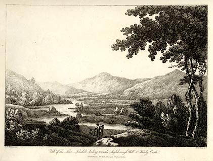 click to enlarge click to enlargeWKN101.jpg Plate 1 in Select Views in Cumberland, Westmoreland, and Lancashire. printed at bottom left, right, centre:- "Revd. J. Wilkinson delt. / W. F. Wells sct. / Vale of the Lune, Lonsdale, looking towards Ingleborough Hill &Hornby Castle. / Publish'd July 1. 1810. by R. Ackermann. 101. Strand. London." item:- Fell and Rock Climbing Club : MN4.1 Image © see bottom of page |
|||||||||||||||||||||||||||||||||||||||||||||||||||||||||||||||||
|
|
||||||||||||||||||||||||||||||||||||||||||||||||||||||||||||||||||
| evidence:- | old print:- Westall 1818 placename:- Ingleborough |
|||||||||||||||||||||||||||||||||||||||||||||||||||||||||||||||||
| source data:- | Print, uncoloured aquatint, The Trees above Weathercote Cave, Yorkshire, drawn and
engraved by William Westall, published by John Murray, Albemarle Street, London, 1818.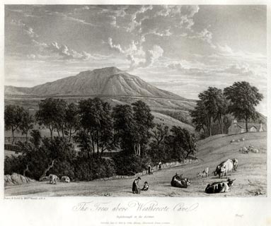 click to enlarge click to enlargeWTL205.jpg "Drawn & Etch'd by Willm. Westall A.R.A. / The Trees above Weathercote Cave. / Ingleborough in the distance. / Publish'd July 12. 1818. by John Murray, Albemarle Street, London. / Proof" item:- Armitt Library : A6670.5 Image © see bottom of page |
|||||||||||||||||||||||||||||||||||||||||||||||||||||||||||||||||
|
|
||||||||||||||||||||||||||||||||||||||||||||||||||||||||||||||||||
| evidence:- | descriptive text:- Otley 1823 (8th edn 1849) placename:- Station of Fire |
|||||||||||||||||||||||||||||||||||||||||||||||||||||||||||||||||
| source data:- | Guide book, A Concise Description of the English Lakes, the
mountains in their vicinity, and the roads by which they may be
visited, with remarks on the mineralogy and geology of the
district, by Jonathan Otley, published by the author, Keswick,
Cumberland now Cumbria, by J Richardson, London, and by Arthur
Foster, Kirkby Lonsdale, Cumbria, 1823; published 1823-49,
latterly as the Descriptive Guide to the English Lakes. goto source Page 202:- "..." "INGLEBOROUGH.- This noble mountain is a prominent feature in the scenery of this portion of the country. From every part its table land is seen cleaving the skies; and an ascent upon its summit, on a clear day, is one of the most delightful excursions that can be undertaken. It stands upon a base of at least thirty miles in circumference, and its highest elevation is 2361 feet above the level of the sea. The views from the top are splendid. The whole extent of country from the north to the south, with the Irish Sea in the west, can be distinctly traced as in a map. In the north-west, the confused heaps of mountains in the Lake district, with their grotesque outlines, terminate the prospect, at a distance of 50 miles. Westwards, it is closed in by the blending of sea and sky. Southwards, after following the indented shores of the Irish Sea, the Welsh mountains lift their broken summits across the horizon. In the east and north-east, black and irregular hills, and deeply-indented valleys, soon terminate the prosect. The plain on the top is about a mile round; and near the western edge is a tower, on the spot formerly occupied by a fire-beacon. It was dignified by the name of a 'Hospice.' Though it has only been built about 30 years, it is now nearly in ruins. Several springs rise near the summit, which generally lose themselves in deep chasms in the sides, the most remarkable of which is Mier Gill. There are" goto sourcePage 203:- "a number of cavities all over the mountain, resembling inverted cones; the most remarkable is 'Barefoot Wives' Hole,' a large funnel-shaped pit, 50 yards in diameter, and about 26 yards deep. It is always dry, the water which may flow into it being swallowed amongst the loose stones at the bottom. These pits are said to be similar to those found on the Mounts Etna and Vesuvius. Ingleborough, or 'The Station of Fire,' has doubtless been, in the time of the Romans, a place of defence, and a beacon of 'smoke by day and fire by night' to communicate the intelligence of any irruption or insurrection to the surrounding castelli and encampments." "" "Soft twilight hues are blending o'er thee now," "Hill of my native vale; 'mid cloudless skies" "Thy giant cliffs in peaceful grandeur rise," "And the light mists are wreathed round thy brow;" "Erewhile the thunder cloud's abiding place" "Where closed the elements in fearful strife -" "Yet of its ravages the tempest rife" "With desolation, there has left no trace" "Distinguishable 'neath the purple vest" "Of Ev'ning, now thy form enveloping." "Like thine, the Wanderer's eve with peace be blest," "The troubles o'er Life's dark day chequering:" "And Hope to cheer him, still in mercy given," "Then gently guide him to her native heaven.[1]" "P." "..." "[1] For this and the preceding Sonnet on Ravenwray, we are indebted to a Reverend Vicar - a school-fellow, class-fellow, and, through life, a dear friend of ours - who lived beloved - close by the scenery he so well portrays - and died alike lamented by all, high and low, rich and poor. He was the only man we have known who had, what is vulgarly called, 'the good word' of every body. To him we are also beholden for the description of the Norman Font in Ingleton Church, as well as for being instrumental in the bringing out of a drawing of it by a Yorkshire artist, Mr. Binns, of Halifax - as accurate as his portraits: we can give it no higher panegyric." |
|||||||||||||||||||||||||||||||||||||||||||||||||||||||||||||||||
|
|
||||||||||||||||||||||||||||||||||||||||||||||||||||||||||||||||||
| evidence:- | descriptive text:- Otley 1823 (5th edn 1834) item:- latitude; longitude; lat and long |
|||||||||||||||||||||||||||||||||||||||||||||||||||||||||||||||||
| source data:- | Guide book, A Concise Description of the English Lakes, the
mountains in their vicinity, and the roads by which they may be
visited, with remarks on the mineralogy and geology of the
district, by Jonathan Otley, published by the author, Keswick,
Cumberland now Cumbria, by J Richardson, London, and by Arthur
Foster, Kirkby Lonsdale, Cumbria, 1823; published 1823-49,
latterly as the Descriptive Guide to the English Lakes. goto source Page 78:- "STATION I.- SCAWFELL highest point, THE PIKES." "Latitude 54° 27′ 24″ N. Longitude 3° 12′W. Height 3160 feet." goto sourcePage 78:- "STATION II.- SKIDDAW." "Latitude 54° 39′ 12″ N. Longitude 3° 8′ 9″W. Height 3022 feet." goto sourcePage 79:- "STATION III.- HELVELLYN." "Latitude 54° 31′ 43″ N. Longitude 3° 0′ 24″W. Height 3070 feet." goto sourcePage 79:- "STATION IV.- CONISTON OLD MAN." "Latitude 54° 22′ 20″ N. Longitude 3° 6′ 34″W. Height 2577 feet."
|
|||||||||||||||||||||||||||||||||||||||||||||||||||||||||||||||||
|
|
||||||||||||||||||||||||||||||||||||||||||||||||||||||||||||||||||
| evidence:- | old map:- Ford 1839 map placename:- Ingleboro Hill |
|||||||||||||||||||||||||||||||||||||||||||||||||||||||||||||||||
| source data:- | Map, uncoloured engraving, Map of the Lake District of
Cumberland, Westmoreland and Lancashire, scale about 3.5 miles
to 1 inch, published by Charles Thurnam, Carlisle, and by R
Groombridge, 5 Paternoster Row, London, 3rd edn 1843.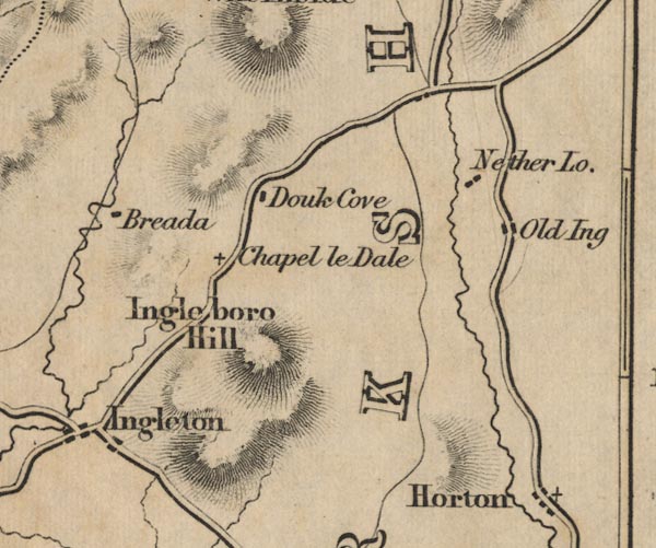 FD02SD77.jpg "Ingleboro Hill" Hill hachuring. item:- JandMN : 100.1 Image © see bottom of page |
|||||||||||||||||||||||||||||||||||||||||||||||||||||||||||||||||
|
|
||||||||||||||||||||||||||||||||||||||||||||||||||||||||||||||||||
| evidence:- | descriptive text:- Clarke 1858 placename:- Ingleborough |
|||||||||||||||||||||||||||||||||||||||||||||||||||||||||||||||||
| source data:- | Report, Account of the Observations and Calculations of the
Principal Triangulation, by Captain Alexander Ross Clarke,
published by the Ordnance Survey, London, 1858. "INGLEBOROUGH, 1807. This station is on top of the mountain of this name, 5 miles east of Ingleton Village, in the West Riding of Yorkshire; it is about 60 yards from the highest part of the an old building towards the north-east, which building is on the nearest brink of Ingleborough from the station south-westward." Altitude above mean sea level:- "2373.4 feet" Position, latitude and longitude, degrees minutes decimal seconds "54 9 58.73 / 2 23 45.87" |
|||||||||||||||||||||||||||||||||||||||||||||||||||||||||||||||||
|
|
||||||||||||||||||||||||||||||||||||||||||||||||||||||||||||||||||
| evidence:- | old map:- Balderston c1890 map placename:- Ingleborough |
|||||||||||||||||||||||||||||||||||||||||||||||||||||||||||||||||
| source data:- | Map, the hills in the Ingleton area, probably by Robert R
Balderston, engraved by Goodall and Suddick, Leeds, West
Yorkshire, about 1890.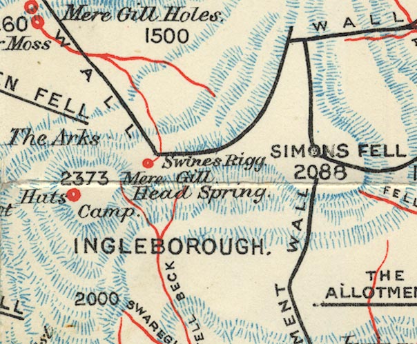 BS1SD77M.jpg "INGLEBOROUGH" item:- private collection : 27.1 Image © see bottom of page |
|||||||||||||||||||||||||||||||||||||||||||||||||||||||||||||||||
|
|
||||||||||||||||||||||||||||||||||||||||||||||||||||||||||||||||||
Lakes Guides menu.