 Old Cumbria Gazetteer
 |
 |
|
|
| Eden Valley Railway | |||
| EVR | |||
| Westmorland Railway | |||
| civil parish:- | Kirkby Stephen (formerly Westmorland) | ||
| civil parish:- | Waitby (formerly Westmorland) | ||
| civil parish:- | Soulby (formerly Westmorland) | ||
| civil parish:- | Musgrave (formerly Westmorland) | ||
| civil parish:- | Warcop (formerly Westmorland) | ||
| civil parish:- | Murton (formerly Westmorland) | ||
| civil parish:- | Appleby-in-Westmorland (formerly Westmorland) | ||
| civil parish:- | Crackenthorpe (formerly Westmorland) | ||
| civil parish:- | Long Marton (formerly Westmorland) | ||
| civil parish:- | Kirkby Thore (formerly Westmorland) | ||
| civil parish:- | Temple Sowerby (formerly Westmorland) | ||
| civil parish:- | Brougham (formerly Westmorland) | ||
| civil parish:- | Clifton (formerly Westmorland) | ||
| civil parish:- | Penrith (formerly Cumberland) | ||
| civil parish:- | Dacre (formerly Cumberland) | ||
| county:- | Cumbria | ||
| locality type:- | railway | ||
| SummaryText:- | from Kirkby Stephen on the South Durham and Lancashire Railway, through Musgrave, Warcop, Appleby, Kirkby Thore, Cliburn, to Clifton on the Lancaster and Carlisle Railway, Cumberland. | ||
| SummaryText:- | When Tebay was chosen as the west endpoint of a route from east to west coast lines, local interests proposed the EVR to link to Clifton and Penrith. | ||
| references:- | 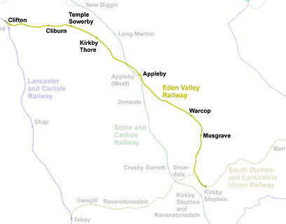 click to enlarge click to enlargeRWY010.jpg |
||
|
|
|||
| evidence:- | old map:- OS County Series (Wmd 16 14) placename:- Eden Valley branch |
||
| source data:- | Maps, County Series maps of Great Britain, scales 6 and 25
inches to 1 mile, published by the Ordnance Survey, Southampton,
Hampshire, from about 1863 to 1948. |
||
|
|
|||
| evidence:- | old map:- Garnett 1850s-60s H |
||
| source data:- | Map of the English Lakes, in Cumberland, Westmorland and
Lancashire, scale about 3.5 miles to 1 inch, published by John
Garnett, Windermere, Westmorland, 1850s-60s.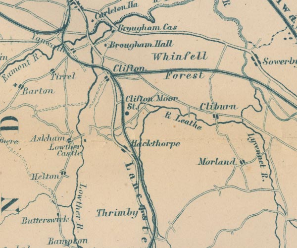 GAR2NY52.jpg triple line, light bold light, railway 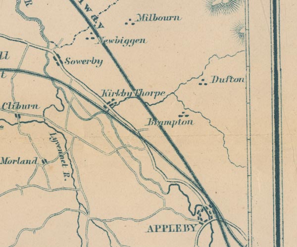 GAR2NY62.jpg 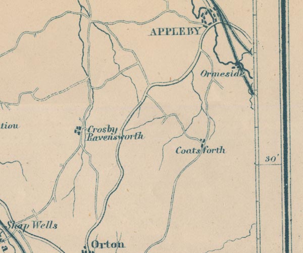 GAR2NY61.jpg item:- JandMN : 82.1 Image © see bottom of page |
||
|
|
|||
| evidence:- | old map:- North Eastern Railway c1900 placename:- North Eastern Railway |
||
| source data:- | Railway map, wall map of coloured ceramic tiles, North Eastern
Railway, scale about 2.5 miles to 1 inch, made by Craven,
Dunnill and Co, Jackfield, Shropshire, about 1900.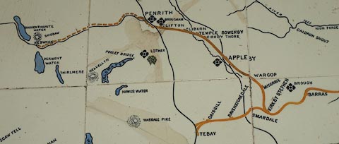 click to enlarge click to enlargeNER1R2.jpg item:- National Railway Museum : 1995-7786 Image © see bottom of page |
||
|
|
|||
| :- |
A draft prospectus written October 1857 calls it the Westmorland Railway; when issued
the prospectus named it Eden Valley Railway, December 1857. |
||
| Thomas Bouch was the engineer. Two routes were proposed; west of the river via Morland,
and the route used, east of the river via warcop. |
|||
| Worked from the start by The Stockton and Darlington Railway. |
|||
| Walton, Peter: 1992: Stainmore and Eden Valley Railways: Oxford Publishing Co (Sparkford,
Somerset):: ISBN 0 86093 306 7 Western, Robert: 1997: Eden Valley Railway: Oakwood Press (Headington, Oxford):: ISBN 0 85361 486 5 |
|||
|
|
|||
| person:- | railway company : Eden Valley Railway; EVR |
||
| date:- | 1858 to 1923 |
||
|
|
|||
| person:- | railway company : Stockton and Darlington Railway; StDR |
||
| date:- | 1862 to 1863 |
||
|
|
|||
| person:- | railway company : North Eastern Railway; NER |
||
| date:- | 1863 to 1923 |
||
|
|
|||
| person:- | railway company : London and North Eastern Railway; LNER |
||
| date:- | 1923 to 1948 |
||
|
|
|||
| person:- | railway company : British Railways; BR |
||
| date:- | 1948 |
||
|
|
|||
| goes through:- |  Kirkby Stephen Junction, Kirkby Stephen railway bridge, Waitby (4) Waitby Crossing, Waitby railway bridge, Soulby (2) lineside hut, Soulby railway bridge, Soulby railway bridge, Soulby (4) Scandal Bridge, Soulby railway bridge, Musgrave (2) Eden Bridge, Great Musgrave railway bridge, Musgrave Musgrave Station, Great Musgrave Warcop Station, Warcop railway bridge, Warcop (2) railway bridge, Warcop Coupland Viaduct, Warcop Brough Bridge, Murton railway bridge, Appleby (4) railway bridge, Appleby (3) Appleby East Station, Appleby level crossing, Appleby Appleby Junction, Appleby Kirkby Thore Station, Kirkby Thore railway bridge, Crackenthorpe railway bridge, Kirkby Thore (3) railway bridge, Temple Sowerby Kirkby Stephen Junction, Kirkby Stephen railway bridge, Waitby (4) Waitby Crossing, Waitby railway bridge, Soulby (2) lineside hut, Soulby railway bridge, Soulby railway bridge, Soulby (4) Scandal Bridge, Soulby railway bridge, Musgrave (2) Eden Bridge, Great Musgrave railway bridge, Musgrave Musgrave Station, Great Musgrave Warcop Station, Warcop railway bridge, Warcop (2) railway bridge, Warcop Coupland Viaduct, Warcop Brough Bridge, Murton railway bridge, Appleby (4) railway bridge, Appleby (3) Appleby East Station, Appleby level crossing, Appleby Appleby Junction, Appleby Kirkby Thore Station, Kirkby Thore railway bridge, Crackenthorpe railway bridge, Kirkby Thore (3) railway bridge, Temple Sowerby[linside hut, Temple Sowerby] Temple Sowerby Station, Temple Sowerby Skygarth Viaduct, Temple Sowerby Cliburn Station, Brougham Wetheriggs Junction, Clifton Wetheriggs Pottery Siding, Wetheriggs railway bridge, Clifton (5) Clifton Station, Clifton Eden Valley Junction, Clifton21.5.1858: authorized - 1862: opened - 22.1.1962: closed, passengers - |
||
|
|
|||
| goes through:- | railway bridge, Clifton (4) railway bridge, Clifton (3) |
||
|
|
|||
| goes through:- | Eamont Bridge Junction, Dacre railway bridge, Skirsgill [Redhills Junction, Penrith] |
||
|
|
|||
Lakes Guides menu.