 Old Cumbria Gazetteer
 |
 |
|
| Skygarth Viaduct, Temple Sowerby | ||
| gone | ||
| Skygarth Viaduct | ||
| site name:- | Eden Valley Railway | |
| site name:- | Eden, River | |
| locality:- | Skygarth | |
| civil parish:- | Temple Sowerby (formerly Westmorland) | |
| county:- | Cumbria | |
| locality type:- | railway viaduct | |
| locality type:- | viaduct | |
| coordinates:- | NY60762613 | |
| coordinates:- | NY60902612 | |
| 1Km square:- | NY6026 | |
| 10Km square:- | NY62 | |
| references:- | OS County Series |
|
|
|
||
| evidence:- | old map:- OS County Series (Wmd 8 4) placename:- Skygarth Viaduct item:- railway milepost |
|
| source data:- | Maps, County Series maps of Great Britain, scales 6 and 25
inches to 1 mile, published by the Ordnance Survey, Southampton,
Hampshire, from about 1863 to 1948.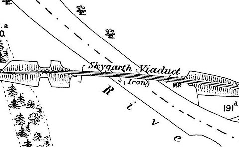 click to enlarge click to enlargeCSRY0198.jpg "Skygarth Viaduct (Iron) / M.P." |
|
|
|
||
 Lakes Guides menu.