 Old Cumbria Gazetteer
 |
 |
|
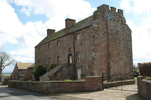
| Drumburgh Castle, Drumburgh | ||
| Drumburgh Castle | ||
| locality:- | Drumburgh | |
| locality:- | Hadrian's Wall | |
| civil parish:- | Bowness (formerly Cumberland) | |
| county:- | Cumbria | |
| locality type:- | castle | |
| coordinates:- | NY26575977 | |
| 1Km square:- | NY2659 | |
| 10Km square:- | NY25 | |
|
|
||
 BUH67.jpg (taken 3.4.2011) 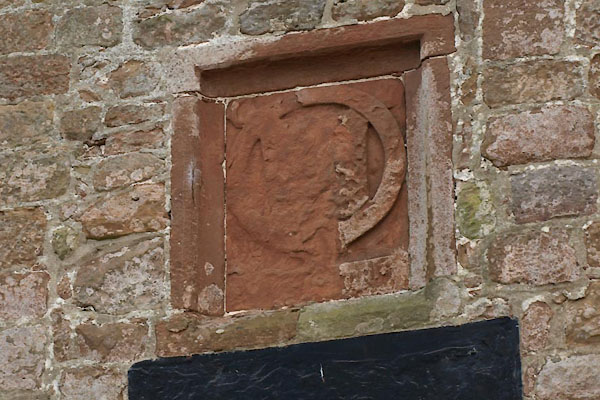 BUH68.jpg Coat of arms. (taken 3.4.2011) |
||
|
|
||
| evidence:- | old map:- OS County Series (Cmd 15 10) placename:- Drumburgh Castle |
|
| source data:- | Maps, County Series maps of Great Britain, scales 6 and 25
inches to 1 mile, published by the Ordnance Survey, Southampton,
Hampshire, from about 1863 to 1948. "Drumburgh Castle" and in english black letter:- "Castle (Remains of)" |
|
|
|
||
| evidence:- | old map:- Saxton 1579 placename:- Drumbugh Castle |
|
| source data:- | Map, hand coloured engraving, Westmorlandiae et Cumberlandiae Comitatus ie Westmorland
and Cumberland, scale about 5 miles to 1 inch, by Christopher Saxton, London, engraved
by Augustinus Ryther, 1576, published 1579-1645.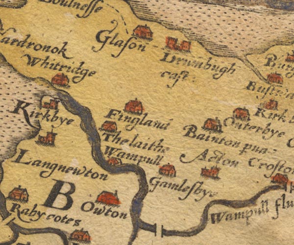 Sax9NY25.jpg Building with two towers, symbol for a castle. "Drumbugh cast:" item:- private collection : 2 Image © see bottom of page |
|
|
|
||
| evidence:- | old map:- Mercator 1595 (edn?) placename:- Drumbugh Castle |
|
| source data:- | Map, hand coloured engraving, Northumbria, Cumberlandia, et
Dunelmensis Episcopatus, ie Northumberland, Cumberland and
Durham etc, scale about 6.5 miles to 1 inch, by Gerard Mercator,
Duisberg, Germany, about 1595.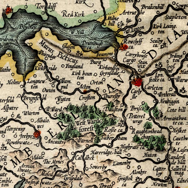 MER8CumC.jpg "Drumbugh ca." circle, building and tower item:- JandMN : 169 Image © see bottom of page |
|
|
|
||
| evidence:- | old map:- Speed 1611 (Cmd) placename:- Drumbugh Castle |
|
| source data:- | Map, hand coloured engraving, Cumberland and the Ancient Citie
Carlile Described, scale about 4 miles to 1 inch, by John Speed,
1610, published by J Sudbury and George Humble, Popes Head
Alley, London, 1611-12.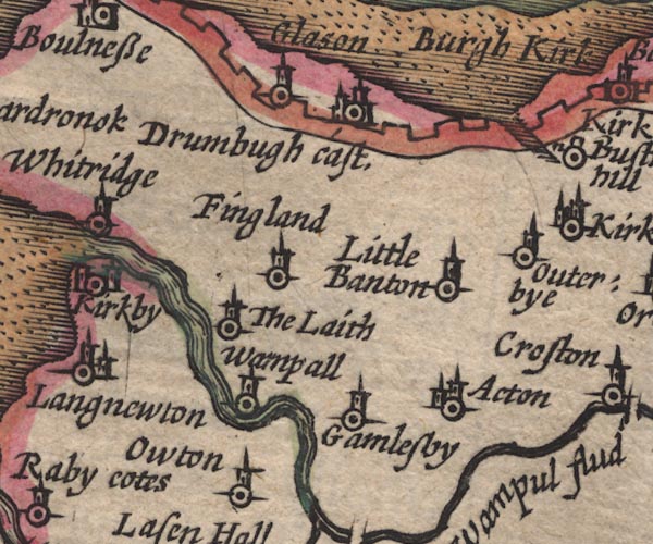 SP11NY25.jpg "Drumbugh cast." circle, buildings, tower item:- private collection : 16 Image © see bottom of page |
|
|
|
||
| evidence:- | old map:- Jansson 1646 placename:- Drumbugh Castle |
|
| source data:- | Map, hand coloured engraving, Cumbria and Westmoria, ie
Cumberland and Westmorland, scale about 3.5 miles to 1 inch, by
John Jansson, Amsterdam, Netherlands, 1646.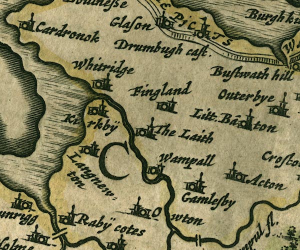 JAN3NY25.jpg "Drumbugh cast" Buildings and tower with flag. item:- JandMN : 88 Image © see bottom of page |
|
|
|
||
| evidence:- | old map:- Sanson 1679 placename:- Dramburgh |
|
| source data:- | Map, hand coloured engraving, Ancien Royaume de Northumberland
aujourdhuy Provinces de Nort, ie the Ancient Kingdom of
Northumberland or the Northern Provinces, scale about 9.5 miles
to 1 inch, by Nicholas Sanson, Paris, France, 1679. click to enlarge click to enlargeSAN2Cm.jpg "Dramburgh" circle, two towers, flag; castle item:- Dove Cottage : 2007.38.15 Image © see bottom of page |
|
|
|
||
| evidence:- | old map:- Morden 1695 (Cmd) placename:- Drumbugh Castle |
|
| source data:- | Map, uncoloured engraving, Cumberland, scale about 4 miles to 1
inch, by Robert Morden, 1695, published by Abel Swale, the
Unicorn, St Paul's Churchyard, Awnsham, and John Churchill, the
Black Swan, Paternoster Row, London, 1695-1715.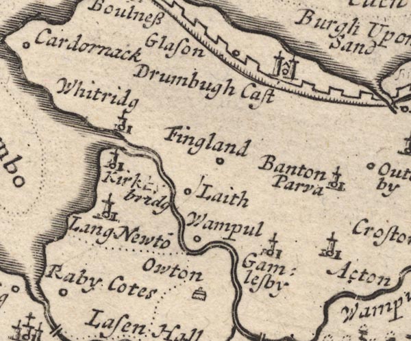 MD12NY25.jpg "Drumbugh Cast" Circle, building with two towers. item:- JandMN : 90 Image © see bottom of page |
|
|
|
||
| evidence:- | old map:- Badeslade 1742 placename:- Drumburg Castle |
|
| source data:- | Map, uncoloured engraving, A Map of Cumberland North from
London, scale about 11 miles to 1 inch, with descriptive text,
by Thomas Badeslade, London, engraved and published by William
Henry Toms, Union Court, Holborn, London, 1742. click to enlarge click to enlargeBD10.jpg "Drumburg C" circle, italic lowercase text; castle item:- JandMN : 115 Image © see bottom of page |
|
|
|
||
| evidence:- | descriptive text:- Simpson 1746 placename:- Drumburgh Castle placename:- Castra Exploratorum |
|
| source data:- | Atlas, three volumes of maps and descriptive text published as
'The Agreeable Historian, or the Compleat English Traveller
...', by Samuel Simpson, 1746. goto source goto source"..." "Drumburgh-Castle, the Seat of Gamel de Brune, anciently given him by one of the first Barons of Burgh, soon after the Conquest, but afterwards the Possession of the Lord Dacre. In the Time of the Romans it was made a Station, and some will have it to be the Castra Exploratorum; but the Distances will by no Means allow it. ..." goto source"Drumburgh Castle and" "Greystock-Castle, both Seats of his Grace Edward Howard, Duke of Norfolk, Hereditary Earl Marshall and first Duke of England, after the Princes of the Royal Family. He marry'd a Daughter of Edward Blount, Esq; of Blagden in Devonshire, and his Lady Arabella, the Daughter of Sir John Guise, Bart. of Rencomb in Gloucestershire. Another of whose Daughters is marry'd to his Grace's Brother, the Hon. Philip Howard, Esq;" |
|
|
|
||
| evidence:- | old map:- Bowen and Kitchin 1760 placename:- Drumbough Castle |
|
| source data:- | Map, hand coloured engraving, A New Map of the Counties of
Cumberland and Westmoreland Divided into their Respective Wards,
scale about 4 miles to 1 inch, by Emanuel Bowen and Thomas
Kitchin et al, published by T Bowles, Robert Sayer, and John
Bowles, London, 1760.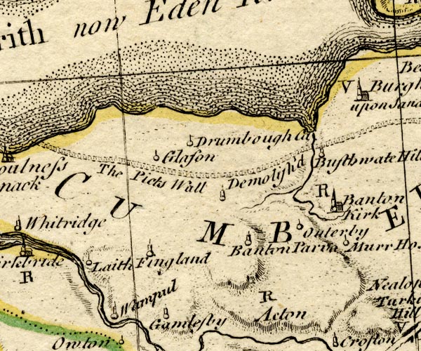 BO18NY25.jpg "Drumbough Ca" circle line and ?flag item:- Armitt Library : 2008.14.10 Image © see bottom of page |
|
|
|
||
| evidence:- | old map:- Donald 1774 (Cmd) |
|
| source data:- | Map, hand coloured engraving, 3x2 sheets, The County of Cumberland, scale about 1
inch to 1 mile, by Thomas Donald, engraved and published by Joseph Hodskinson, 29
Arundel Street, Strand, London, 1774.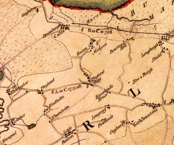 D4NY25NE.jpg "Castle" large building; a castle at Drumburgh item:- Carlisle Library : Map 2 Image © Carlisle Library |
|
|
|
||
| evidence:- | old text:- Clarke 1787 placename:- Drumbugh Castle |
|
| source data:- | Guide book, A Survey of the Lakes of Cumberland, Westmorland,
and Lancashire, written and published by James Clarke, Penrith,
Cumberland, and in London etc, 1787; published 1787-93. goto source Page 105:- "..." "I do not find any ancient authors mention a castle here [Castlerigg], Speed, who speaks of twenty-five in Cumberland, hath found out every one I ever heard or knew of, except Kirkoswald; how that has escaped him I cannot tell. I shall here put down their names, and, as well as I can, their most ancient owners, and supposed founders." "..." goto sourcePage 106:- "..." "10. DRUMBUGH. Built by Thomas de Moulton in Henry III.'s time." "..." |
|
|
|
||
| evidence:- | old text:- Camden 1789 placename:- Drumbough Castle |
|
| source data:- | Book, Britannia, or A Chorographical Description of the Flourishing Kingdoms of England,
Scotland, and Ireland, by William Camden, 1586, translated from the 1607 Latin edition
by Richard Gough, published London, 1789. goto source Page 173:- "..." "Lower down on the same frith, more inland, is Drumbough castle, formerly belonging to the lords Dacre, and antiently a Roman station. ..." |
|
|
|
||
| evidence:- | old text:- Camden 1789 (Gough Additions) item:- placename, Drumburgh Castle |
|
| source data:- | Book, Britannia, or A Chorographical Description of the Flourishing Kingdoms of England,
Scotland, and Ireland, by William Camden, 1586, translated from the 1607 Latin edition
by Richard Gough, published London, 1789. goto source Page 187:- "... Drumburgh, where is a fort ... Abundance of stones have been taken out of it, and it is probable the house and garden walls were built of them, whence, and not from its form, it has the name of castle." "..." ""At Drumburgh the lord Dakers father builded upon old ruines a prety pile for defens of the country. It is almost in the middle way betwixt Bolnes and Burgh. The stones of the Pict wall were pulled down to build it, for the wall is very nigh it."" |
|
|
|
||
| evidence:- | old text:- Camden 1789 (Gough Additions) item:- placename, Drumburgh Castle |
|
| source data:- | Book, Britannia, or A Chorographical Description of the Flourishing Kingdoms of England,
Scotland, and Ireland, by William Camden, 1586, translated from the 1607 Latin edition
by Richard Gough, published London, 1789. goto source Page 229, quoting Mr Horsley:- "..." ""At DRUMBRUGH is a fort about five chains square, whose ramparts are large, and the ditch very deep. Out of this fort abundance of stones have been taken. It is very probable, that the house and garden walls have been built with the stones of the wall and station, and that it has the name of castle (as Whitley castle) from the old Roman fort; for the seat is not built in the form of a castle. ..."" |
|
|
|
||
| evidence:- | road book:- Cary 1798 (2nd edn 1802) |
|
| source data:- | Road book, itineraries, Cary's New Itinerary, by John Cary, 181
Strand, London, 2nd edn 1802. goto source click to enlarge click to enlargeC38555.jpg page 555-556 "At Drumburgh, the Castle." item:- JandMN : 228.2 Image © see bottom of page |
|
|
|
||
| evidence:- | old map:- Laurie and Whittle 1806 placename:- Drumburgh Castle |
|
| source data:- | Road map, Completion of the Roads to the Lakes, scale about 10
miles to 1 inch, by Nathaniel Coltman? 1806, published by Robert
H Laurie, 53 Fleet Street, London, 1834. click to enlarge click to enlargeLw18.jpg "Drumburgh Castle 315¼" castle; distance from London item:- private collection : 18.18 Image © see bottom of page |
|
|
|
||
| evidence:- | old map:- Ford 1839 map placename:- Drumburgh Castle |
|
| source data:- | Map, uncoloured engraving, Map of the Lake District of
Cumberland, Westmoreland and Lancashire, scale about 3.5 miles
to 1 inch, published by Charles Thurnam, Carlisle, and by R
Groombridge, 5 Paternoster Row, London, 3rd edn 1843. FD02NY26.jpg "Drumburgh Castle" item:- JandMN : 100.1 Image © see bottom of page |
|
|
|
||
| evidence:- | old text:- Gents Mag placename:- Drombogh |
|
| source data:- | Magazine, The Gentleman's Magazine or Monthly Intelligencer or
Historical Chronicle, published by Edward Cave under the
pseudonym Sylvanus Urban, and by other publishers, London,
monthly from 1731 to 1922. goto source Gentleman's Magazine 1856 part 2 pp.208-215 "LICENCES TO CRENELLATE GRANTED BY" "..." "EDWARD II. A.D. 1307. July 8. 1327. Jan. 20." "..." "1. Ricardus le Brun mansum suum Drombogh in marchia Scotiae ... Cumbr." "..." |
|
|
|
||
| evidence:- | text:- Curwen 1913 placename:- Drombogh item:- licence to crenellate |
|
| source data:- | Book, The Castles and Fortified Towers of Cumberland,
Westmorland, and Lancashire North of the Sands, by John F
Curwen, published for the Cumberland and Westmorland Antiquarian
and Archaeological Society by Titus Wilson, Kendal, Westmorland,
1913. Licence to crenellate granted by Edward II; 24 August 1307:- "Ricardus le Brun ... mansum suum ... Drombogh in marchia Scotiae, Cumberland." |
|
|
|
||
| evidence:- | database:- Listed Buildings 2010 placename:- Drumburgh Castle item:- coat of arms; date stone (1518) |
|
| source data:- | courtesy of English Heritage "DRUMBURGH CASTLE / / / BOWNESS / ALLERDALE / CUMBRIA / I / 71900 / NY2657759765" |
|
| source data:- | courtesy of English Heritage "Tower House, now farmhouse. C13, licence to crenellate granted to Robert le Brun 24 August 1307. Alterations originally dated 1518 with initials and coat of arms of Thomas Lord Dacre over entrance; further alterations between 1678 and 1681 for John Aglionby and C19 additions. Extremely thick walls of squared and coursed red sandstone (from the nearby Roman Wall) on chamfered plinth, parapet over entrance with carved stone eagle finials; steeply pitched graduated greenslate roof with coped gables, brick chimney stacks. 3 storeys (formerly 4 storeys), 5 bays; single-storey single-bay extension to left. C19 gabled brick porch with Welsh slate roof; to right is a blocked round-headed C13 window. C13 blocked round-headed ground floor entrance is partly covered by C16 or C17 external stone steps to first floor. 1517 entrance; iron-studded oak plank door could be original (with later internal lock dated and inscribed J.L. 1681) in pointed-arched and chamfered surround with carved stone panel of arms above. Ground floor and first floor sash windows with glazing bars in enlarged C16 openings. Continuous row of blocked slit vents above. Second floor C16 2-light stone-mullioned windows now have Yorkshire sashes with mullions removed; blocked third floor windows slightly above and between these windows. Rear wall has similar windows and blocked windows. End wall right, which was in danger of collapse, was completely taken down in the late 1970's and rebuilt in facsimile, with broad central buttress and corbelled-out battlemented parapet, which may have been the remains of medieval crenellation. Floor levels of interior changed in C16 and Cl7: many original features will be covered by later plasterwork. First floor C17 wood-panelled room. Interior of rebuilt end is entirely of breeze blocks and open from floor to roof; roof of king-post trusses could be C16. See Curwen, Castles & Towers of Cumberland &Westmorland, 1913, pp202-3; Medieval Archaeology, vol xxiii, 1979, p270. Extension to left of Roman Wall stone and cobbles with greenslate roof. End wall has plank doors and slatted openings." |
|
|
|
||
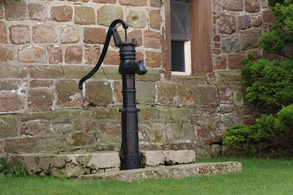 BUH69.jpg Pump. (taken 3.4.2011) |
||
|
|
||
| notes:- |
16th century stone house or tower, converted from a 13th century hall |
|
| Perriam, D R &Robinson, J: 1998: Medieval Fortified Buildings of Cumbria: CWAAS::
ISBN 1 873124 23 6; plan and illustration |
||
|
|
||
Lakes Guides menu.