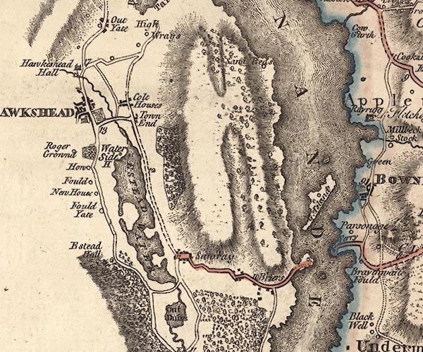
 Jefferys 1770 SD39NE

|

|
|
|
gazetteer links places may or may not be labelled on the map |
||

|
-- Belle Isle -- "G. Island" |
|
|
|
-- Black Beck |
|
|
|
-- Bryers Fold -- "Briars" |
|
|
|
-- Claife Heights |
|
|
|
-- Colthouse -- "Colt Houses" |
|
|
|
-- Ees Bridge |
|
|
|
-- Esthwaite Hall -- "Estead Hall" |
|
|
|
-- Esthwaite Water -- "ESTEAD WATER" |
|
|
|
-- Fold Gate -- "Fould Yate" |
|
|
|
-- garden, Hawkshead |
|
|
|
-- Hawkshead Fields House -- "Fould" |
|
|
|
-- Hawkshead Old Hall -- "Hawkeshead Hall" |
|
|
|
-- Hawkshead Saw Mill |
|
|
|
-- Hawkshead -- "HAWKSHEAD" |
|
|
|
-- Howe Farm -- "How" |
|
|
|
-- Near Sawrey -- "Sawray" |
|
|
|
-- New House -- "New House" |
|
|
|
-- Pool Bridge |
|
|
|
-- Ambleside to Hawkshead |
|
|
|
-- Kendal to Hawkshead |
|
|
|
-- Roger Ground House -- "Roger Grownd" |
|
|
|
-- Sand Beds -- "Sand Beds" |
|
|
|
-- St Michael and All Angels Church |
|
|
|
-- Town End -- "Town End" |
|
|
|
-- Water Side Woods |
|
|
|
-- Water Side -- "Water Side H." |
|
|
|
-- Windermere Ferry (?) -- "Ferry" |
|
|
|
-- Windermere lake -- "WINANDERMERE" |
|
|
civil parishes The area roughly includes parts of parishes:- Hawkshead Claife Windermere Lakes |
||
|
|
||
|
|
Lakes Guides menu. | |