 Old Cumbria Gazetteer
 |
 |
|
|
| road, Ambleside to Hawkshead | |||
| Ambleside to Hawkshead | |||
| Hawkshead to Ambleside | |||
| civil parish:- | Hawkshead (formerly Lancashire) | ||
| civil parish:- | Claife (formerly Lancashire) | ||
| civil parish:- | Lakes (formerly Westmorland) | ||
| county:- | Cumbria | ||
| locality type:- | route | ||
| 10Km square:- | NY30 | ||
| 10Km square:- | SD39 | ||
|
|
|||
| evidence:- | old map:- Jefferys 1770 (Wmd) |
||
| source data:- | Map, 4 sheets, The County of Westmoreland, scale 1 inch to 1
mile, surveyed 1768, and engraved and published by Thomas
Jefferys, London, 1770.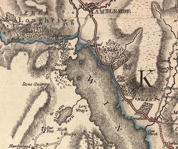 J5NY30SE.jpg 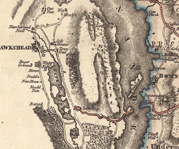 J5SD39NE.jpg double line; road, with mile numbers item:- National Library of Scotland : EME.s.47 Images © National Library of Scotland |
||
|
|
|||
| evidence:- | descriptive text:- West 1778 (11th edn 1821) |
||
| source data:- | Guide book, A Guide to the Lakes, by Thomas West, published by
William Pennington, Kendal, Cumbria once Westmorland, and in
London, 1778 to 1821. goto source goto sourcePage 54:- "..." "At Water-head, the road to the east leads to Ambleside, eight miles; to Hawkshead, three. Ascend a steep hill surronded (sic) with" goto sourcePage 55:- "wood, and have a back view of the lake. ... turn your face to the east, and you have a view of some part of Windermere-water. The road soon divides; the left leads to Ambleside, the right to Hawkshead, which stands under a mountain, at the upper end of a narrow valley. The church is seated on the front of an eminence that commands the vale, which is floated with" |
||
|
|
|||
| evidence:- | old print:- Middiman 1784-92 |
||
| source data:- | Print, uncoloured engraving, View near Ambleside, on the road from Hawkshead, Lancashire,
drawn by F Wheatly, engraved and published by Samuel Middiman, 3 Grafton Street, Tottenham
Court Road, London, 1785.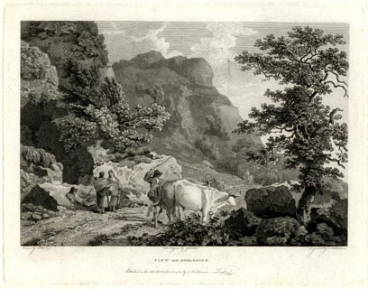 click to enlarge click to enlargeMM0501.jpg "Drawn by F. Wheatly. / Engrav'd by S. Middiman. / VIEW near AMBLESIDE. / Publish'd as the Act directs, Decr. 12. 1785, by S. Middiman, London." Accompanying text:- "PLATE XVII." "VIEW near AMBLESIDE," "WESTMORELAND." "IN the Neighbourhood of Ambleside are many beautiful Waterfalls, which, in a wet Season particularly, are seen precipitating themselves down the Sides of the Hills, in a Style of Grandeur superior to any Thing observed in other mountainous Countries." "At the Head of Winandermere Lake, and about a Mile distant from Ambleside, are the Vestiges of a Roman Camp, which commanded several Passes; it was fortified with a Ditch and Rampart, and had Access only from the South East; its ancient Name is uncertain." "Since the Beginning of the present Century, Forges for making and working Iron have been re-introduced in these Parts. The Wood of the Mountains is appropriated to the Use of the Furnaces, which has raised the Land to many Times the Value it was sixty Years ago." "The annexed View exhibits a romantic Scene on the Road leading from Hawkeshead to Ambleside, and about two Miles distance from the former Place." item:- Armitt Library : A6862.1 Image © see bottom of page |
||
|
|
|||
| evidence:- | old map:- Clarke 1787 map (Windermere N) |
||
| source data:- | Map, A Map of the Northern Part of the Lake Winandermere and its
Environs, scale about 6.5 ins to 1 mile, by James Clarke,
engraved by Samuel John Neele, 352 Strand, published by James
Clarke, Penrith, Cumberland and in London etc, 1787. CLANY30S.jpg 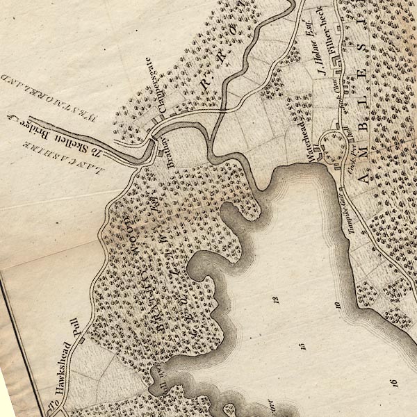 CLANY30R.jpg "To Hawkshead" item:- private collection : 10.10 Image © see bottom of page |
||
|
|
|||
| evidence:- | road map:- Cary 1790 (Lan/edn 1792) |
||
| source data:- | Road map, hand coloured engraving, Lancashire, scale about 18
miles to 1 inch, by John Cary, 181 Strand, London, 1790, edn
1792.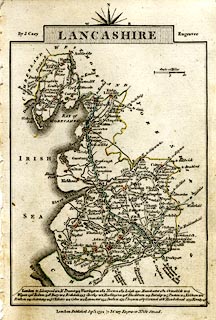 click to enlarge click to enlargeCY46.jpg double line item:- JandMN : 418 Image © see bottom of page |
||
|
|
|||
| evidence:- | old map:- Cooke 1802 |
||
| source data:- | Map, Lancashire, scale about 18 miles to 1 inch, by George
Cooke, 1802, bound in Gray's New Book of Roads, 1824, published
by Sherwood, Jones and Co, Paternoster Road, London, 1824.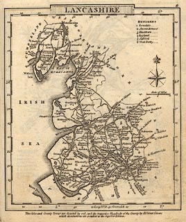 click to enlarge click to enlargeGRA1La.jpg double line, light dark solid; road item:- Hampshire Museums : FA2000.62.6 Image © see bottom of page |
||
|
|
|||
| evidence:- | old map:- Ford 1839 map |
||
| source data:- | Map, uncoloured engraving, Map of the Lake District of
Cumberland, Westmoreland and Lancashire, scale about 3.5 miles
to 1 inch, published by Charles Thurnam, Carlisle, and by R
Groombridge, 5 Paternoster Row, London, 3rd edn 1843.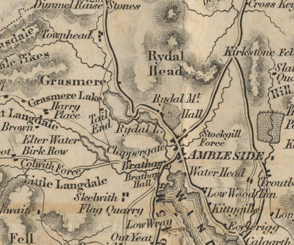 FD02NY30.jpg "H to A 5 Ms."  FD02SD39.jpg item:- JandMN : 100.1 Image © see bottom of page |
||
|
|
|||
| evidence:- | old map:- Prior 1874 map 1 |
||
| source data:- | Map, uncoloured engraving or lithograph? Winander Mere, scale
about 2.5 miles to 1 inch, published by John Garnett,
Windermere, Westmorland, 1874. click to enlarge click to enlargePI03M1.jpg "To Hawkshead" double line; road item:- private collection : 133.1 Image © see bottom of page |
||
|
|
|||
| places:- | Ambleside Clappersgate, Lakes Outgate, Hawkshead Hawkshead |
||
|
|
|||
Lakes Guides menu.