 Jefferys 1770 NY70SW

|

|
|
|
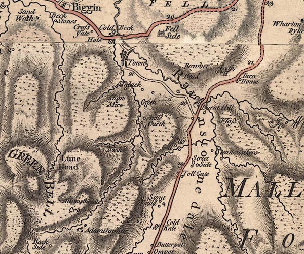
gazetteer links places may or may not be labelled on the map |
||

|
-- Artlegarth Beck |
|
|
|
-- Artlegarth -- "Artle Garth" |
|
|
|
-- Ash Fell -- "Fell Side" |
|
|
|
-- Ashfield -- "Fell Side" |
|
|
|
-- Banks -- "Bank" |
|
|
|
-- Bowber Head -- "Bowber Head" |
|
|
|
-- Bowberhead Farm -- "Bowber Head" |
|
|
|
-- bridge, Ravenstonedale |
|
|
|
-- Brunt Hill -- "Burnt Hill" |
|
|
|
-- Cold Keld -- "Cold Kale" |
|
|
|
-- Coldbeck Bridge |
|
|
|
-- Coldbeck -- "Cold Beck" |
|
|
|
-- Crooks Beck South Bridge |
|
|
|
-- Cross Gates -- "Cross Yate" |
|
|
|
-- Cross -- "Adamthwaite Cross" |
|
|
|
-- Ellergill -- "Eller Gill" |
|
|
|
-- Flass -- "Flass" |
|
|
|
-- Green, The -- "Green" |
|
|
|
-- Harter Fell |
|
|
|
-- High Stennerskeugh -- "Stenhouseskers" |
|
|
|
-- Hole -- "Hole" |
|
|
|
-- Howgill Fells-- Howgill Fells -- "HOUGILL FELLS" |
|
|
|
-- Intake -- "Intack" |
|
|
|
-- Jackson Gill |
|
|
|
-- Low Stennerskeugh -- "Stenhouseskers" |
|
|
|
-- Lune Head -- "Lune Head" |
|
|
|
-- Lytheside Farm -- "Lyth H." |
|
|
|
-- Coldbeck Mill (?) |
|
|
|
-- Ravenstonedale -- "Ravenstonedale" |
|
|
|
-- Ravenstonedale Turn Pike -- "Toll Gate" |
|
|
|
-- Ravenstonedale -- "Town" |
|
|
|
-- Sedbergh to Kirkby Stephen |
|
|
|
-- Ravenstonedale road |
|
|
|
-- Shawmire -- "Shaw Mire" |
|
|
|
-- Stennerskeugh -- "Stenhouseskers" |
|
|
|
-- Street Farm -- "Street Side" |
|
|
|
-- Studfold -- "Stout Fould" |
|
|
|
-- Tarn House -- "Tarn House" |
|
|
|
-- Wyegarth Gill |
|
|
civil parishes The area roughly includes parts of parishes:- Ravenstonedale Waitby Kirkby Stephen |
||
|
|
||
|
|
Lakes Guides menu. | |