 Jefferys 1770 NY42SE

|

|
|
|
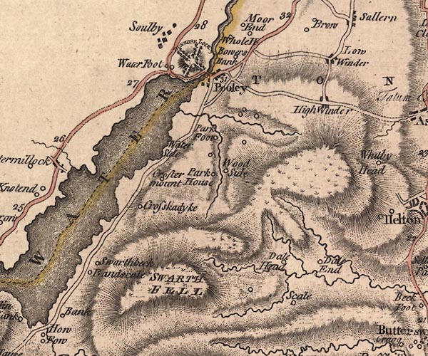
gazetteer links places may or may not be labelled on the map |
||

|
-- Aik Beck |
|
|
|
-- Barton -- "BARTON" |
|
|
|
-- Bonscale -- "Bandscale" |
|
|
|
-- Bowerbank -- "Bowers Bank" |
|
|
|
-- Brown Beck |
|
|
|
-- Crook-a-dyke -- "Crosskadyke" |
|
|
|
-- Cross Dormont -- "Croster mount" |
|
|
|
-- Dalefoot -- "Dale End" |
|
|
|
-- Dalehead -- "Dale Head" |
|
|
|
-- Dunmallard Hill -- "DUNMORE LOCK" |
|
|
|
-- Eamont, River -- "Emont River" |
|
|
|
-- Elder Beck |
|
|
|
-- High Winder -- "High Winder" |
|
|
|
-- Hole House Farm -- "Whole H" |
|
|
|
-- Low Winder -- "Low Winder" |
|
|
|
-- Mossy Beck |
|
|
|
-- Park Foot -- "Park Foot" |
|
|
|
-- Parkhouse -- "Park House" |
|
|
|
-- Pooley Bridge |
|
|
|
-- Pooley Bridge -- "Pooley" |
|
|
|
-- Patterdale to Penrith -- "F. A. to P. 23'4" |
|
|
|
-- Howtown road |
|
|
|
-- Scale -- "Scale" |
|
|
|
-- Swarth Fell -- "SWARTH FELL" |
|
|
|
-- Swarthbeck -- "Swarthbeck" |
|
|
|
-- Ullswater -- "ULLESWATER" |
|
|
|
-- Waterfoot -- "Water Foot" |
|
|
|
-- Waterside House -- "Water Side" |
|
|
|
-- Woodside -- "Wood Side" |
|
|
civil parishes The area roughly includes parts of parishes:- Matterdale Dacre Barton Askham Bampton |
||
|
|
||
|
|
Lakes Guides menu. | |