 Old Cumbria Gazetteer
 |
 |
|
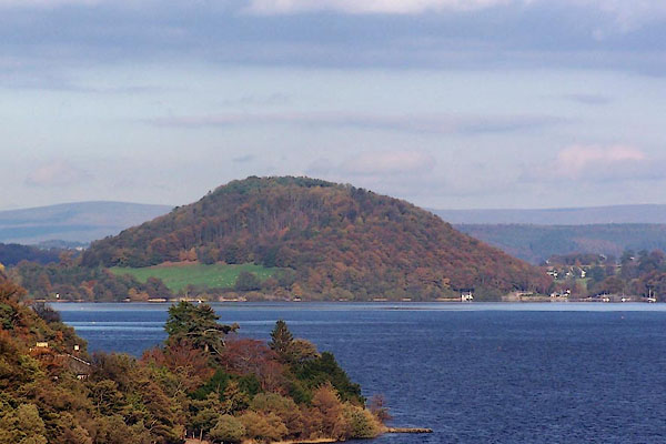
| Dunmallard Hill, Dacre | ||
| Dunmallard Hill | ||
| locality:- | Pooley Bridge | |
| civil parish:- | Dacre (formerly Cumberland) | |
| county:- | Cumbria | |
| locality type:- | hill | |
| coordinates:- | NY46762456 (etc) | |
| 1Km square:- | NY4624 | |
| 10Km square:- | NY42 | |
|
|
||
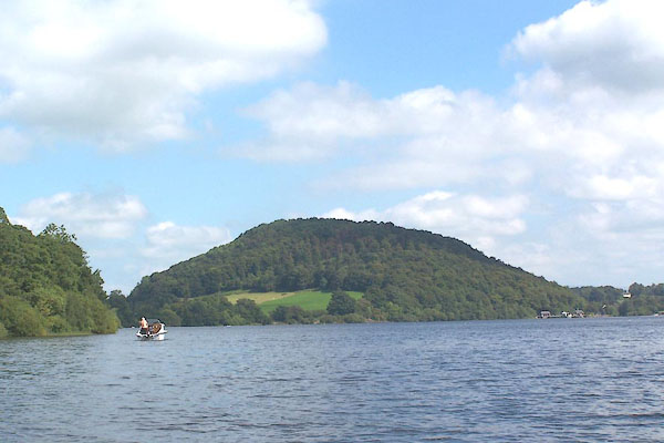 BNZ60.jpg (taken 24.8.2007) 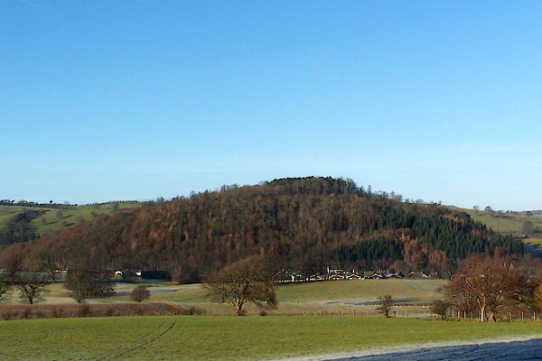 BLN28.jpg (taken 4.1.2006) |
||
|
|
||
| evidence:- | old map:- OS County Series (Cmd 66 2) placename:- Dunmallard Hill |
|
| source data:- | Maps, County Series maps of Great Britain, scales 6 and 25
inches to 1 mile, published by the Ordnance Survey, Southampton,
Hampshire, from about 1863 to 1948. "Dunmallard Hill / CAMP (Remains of)" |
|
|
|
||
| evidence:- | old map:- Morden 1695 (Wmd) placename:- Dunmallard Hill |
|
| source data:- | Map, hand coloured engraving, Westmorland, scale about 2.5 miles to 1 inch, by Robert
Morden, published by Abel Swale, the Unicorn, St Paul's Churchyard, Awnsham, and John
Churchill, the Black Swan, Paternoster Row, London, 1695.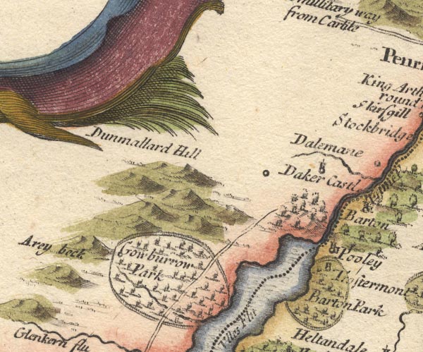 MD10NY42.jpg "Dunmallard Hill" Hillock, the label is misplaced. item:- JandMN : 24 Image © see bottom of page |
|
|
|
||
| evidence:- | descriptive text:- Fiennes 1698 |
|
| source data:- | Travel book, manuscript record of Journeys through England
including parts of the Lake District, by Celia Fiennes, 1698. "... at the end of this Ulls water is a fine round hill look'd as green and full of wood, very pleasant with grass and corne very fruitefull, and hereabout we leave those desart and barren rocky hills, ..." |
|
|
|
||
| evidence:- | old map:- Jefferys 1770 (Wmd) placename:- Dunmore Lock |
|
| source data:- | Map, 4 sheets, The County of Westmoreland, scale 1 inch to 1
mile, surveyed 1768, and engraved and published by Thomas
Jefferys, London, 1770. J5NY42SE.jpg "DUNMORE LOCK" hill hachuring; hill or mountain, and four avenues of trees item:- National Library of Scotland : EME.s.47 Image © National Library of Scotland |
|
|
|
||
| evidence:- | old map:- Donald 1774 (Cmd) placename:- Dunmallet |
|
| source data:- | Map, hand coloured engraving, 3x2 sheets, The County of Cumberland, scale about 1
inch to 1 mile, by Thomas Donald, engraved and published by Joseph Hodskinson, 29
Arundel Street, Strand, London, 1774.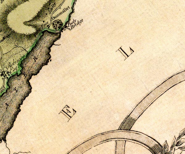 D4NY42SE.jpg "Dunmallet" shown as a wooded hill item:- Carlisle Library : Map 2 Image © Carlisle Library |
|
|
|
||
| evidence:- | descriptive text:- West 1778 (11th edn 1821) placename:- Dunmallet |
|
| source data:- | Guide book, A Guide to the Lakes, by Thomas West, published by
William Pennington, Kendal, Cumbria once Westmorland, and in
London, 1778 to 1821. goto source goto sourcePage 151:- "..." "ULLS-WATER." "Those that do not choose to go as far as Penrith, may, near the eighth mile-post," goto sourcePage 152:- "..." "[Mr. Gray] '... Dunmallet, a fine pointed hill, covered with wood. Began to mount the hill, and with some toil [ gained the summit] ..." goto sourceAddendum; Mr Gray's Journal, 1769 Page 201:- "Oct. 1. A grey autumnal day, the air perfectly calm, and mild, went to see Ulls-water, ... Approached Dunmallet, a fine pointed hill, covered with wood, planted by old Mr. Hazel before-mentioned, who lives always at home [Dalemain], and delights in planting. Walked over a spongy meadow or two, and began to mount the hill, through a broad straight green alley, among the trees, and with some toil gained the summit. From hence saw the lake ... I descended Dunmallet again by the side avenue, that was only not perpendicular, and came to Barton-bridge over the Eamont; ..." |
|
|
|
||
| evidence:- | old map:- Crosthwaite 1783-94 (Ull) placename:- Dunmallet |
|
| source data:- | Map, uncoloured engraving, Accurate Map of the Beautiful Lake of
Ullswater, scale about 3 inches to 1 mile, by Peter Crosthwaite,
Keswick, Cumberland, 1783, version published 1800.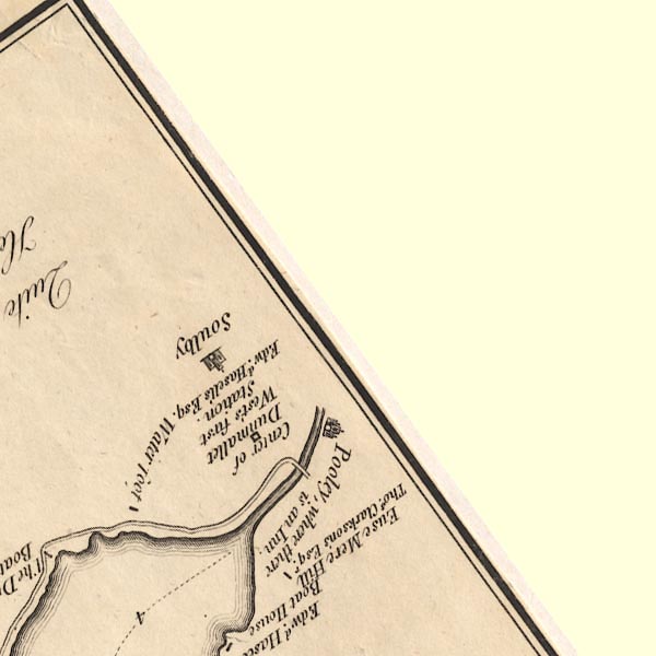 CT5NY42S.jpg "Centre of Dunmallet / West's first Station / Edwd. Hasell's Esq." item:- Armitt Library : 1959.191.7 Image © see bottom of page |
|
|
|
||
| evidence:- | old map:- Crosthwaite 1783-94 (Ull) placename:- Dunmallet |
|
| source data:- | Map, uncoloured engraving, Accurate Map of the Beautiful Lake of
Ullswater, scale about 3 inches to 1 mile, by Peter Crosthwaite,
Keswick, Cumberland, 1783, version published 1800.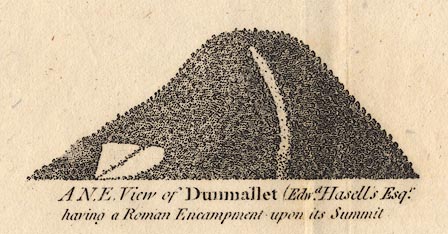 CT05Vgn4.jpg "A N.E. View of Dunmallet (Edwd. Hasell's Esqr. having a Roman Encampment upon its Summit." item:- Armitt Library : 1959.191.7 Image © see bottom of page |
|
|
|
||
| evidence:- | old map:- West 1784 map placename:- Dunmallet |
|
| source data:- | Map, hand coloured engraving, A Map of the Lakes in Cumberland,
Westmorland and Lancashire, scale about 3.5 miles to 1 inch,
engraved by Paas, 53 Holborn, London, about 1784.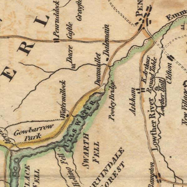 Ws02NY42.jpg item:- Armitt Library : A1221.1 Image © see bottom of page |
|
|
|
||
| evidence:- | old text:- Clarke 1787 placename:- Dunmallard placename:- Down of Mallards |
|
| source data:- | Guide book, A Survey of the Lakes of Cumberland, Westmorland,
and Lancashire, written and published by James Clarke, Penrith,
Cumberland, and in London etc, 1787; published 1787-93. goto source Page 25:- "..." "The first striking object that presents, after embarking upon the Lake, is Dunmallard, a beautiful hill, covered with wood, through which three avenues afford an ascent to the top. It is supposed to take its name from the Down of Mallards, formerly very plentiful here, or rather Dun-mail, King of Cumberland." "Upon the top of Dunmallard was a Monastery of Benedictines; ..." |
|
|
|
||
| evidence:- | old print:- Clarke 1787 placename:- Dunmallard |
|
| source data:- | hill with avenue of trees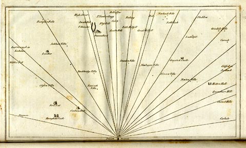 click to enlarge click to enlargeCL18.jpg "Dunmallard" item:- Armitt Library : A6615.12 Image © see bottom of page |
|
|
|
||
| evidence:- | old map:- Clarke 1787 map (Ullswater) placename:- Dunmallard |
|
| source data:- | Map, A Map of the Lake Ullswater and its Environs, scale about
6.5 ins to 1 mile, by James Clarke, engraved by S J Neele, 352
Strand, published by James Clarke, Penrith, Cumberland and in
London etc, 1787. CL4NY42S.jpg "Dunmallard" item:- private collection : 10.4 Image © see bottom of page |
|
|
|
||
| evidence:- | outline view:- Otley 1823 (8th edn 1849) placename:- Dunmallet |
|
| source data:- | Engraving, outline view of mountains, Ullswater from Pooley Bridge, drawn by T Binns,
engraved by O Jewitt, opposite p.12 of A Descriptive Guide of the English Lakes, by
Jonathan Otley, 8th edition, 1849.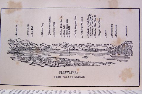 click to enlarge click to enlargeO80E07.jpg item:- Armitt Library : A1180.8 Image © see bottom of page |
|
|
|
||
| evidence:- | descriptive text:- Otley 1823 (5th edn 1834) placename:- Dunmallet |
|
| source data:- | Guide book, A Concise Description of the English Lakes, the
mountains in their vicinity, and the roads by which they may be
visited, with remarks on the mineralogy and geology of the
district, by Jonathan Otley, published by the author, Keswick,
Cumberland now Cumbria, by J Richardson, London, and by Arthur
Foster, Kirkby Lonsdale, Cumbria, 1823; published 1823-49,
latterly as the Descriptive Guide to the English Lakes. goto source Page 8:- "... At the foot of the lake [Ullswater], the water seems to be embanked by a conglomerated mass of pebbles; the same composition forms the finely wooded hill called Dunmallet, which stands like a centinel to guard the pass." |
|
|
|
||
| evidence:- | descriptive text:- Ford 1839 (3rd edn 1843) placename:- Dunmallet |
|
| source data:- | Guide book, A Description of Scenery in the Lake District, by
Rev William Ford, published by Charles Thurnam, Carlisle, by W
Edwards, 12 Ave Maria Lane, Charles Tilt, Fleet Street, William
Smith, 113 Fleet Street, London, by Currie and Bowman,
Newcastle, by Bancks and Co, Manchester, by Oliver and Boyd,
Edinburgh, and by Sinclair, Dumfries, 1839. goto source Page 143:- "... Dunmallet, which the tourist cannot but notice, from its conical figure and its being covered with wood; it was anciently crowned by a Roman station." |
|
|
|
||
| evidence:- | old map:- Ford 1839 map placename:- Dunmallet |
|
| source data:- | Map, uncoloured engraving, Map of the Lake District of
Cumberland, Westmoreland and Lancashire, scale about 3.5 miles
to 1 inch, published by Charles Thurnam, Carlisle, and by R
Groombridge, 5 Paternoster Row, London, 3rd edn 1843.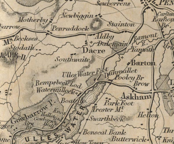 FD02NY42.jpg "Dunmallet" No symbol. item:- JandMN : 100.1 Image © see bottom of page |
|
|
|
||
| evidence:- | old photograph:- Ullswater Steamers 1900s (edn 1903) placename:- Dunmallet item:- |
|
| source data:- | Photograph, bw halftone, yachts and a steam launch, Ullswater and Dunmallet ie Dunmallard
Hill, Dacre, Cumberland, published in a guide book by the Ullswater Steam Navigation
Co, Penrith, Cumberland, 1903.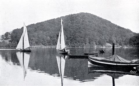 click to enlarge click to enlargeUN119.jpg printed, bottom "ULLSWATER AND DUNMALLET" item:- JandMN : 1023.19 Image © see bottom of page |
|
|
|
||
| evidence:- | outline view:- Red Guide 1892 |
|
| source data:- | Print, engraving, pair of outline views, Mountains as seen from the Road near Buttermere
Church, and Mountains as seen from the Foot of Dun Mallet on Ullswater, published
by Ward, Lock and Co, Warwick House, Salisbury Square, London, etc, 1892.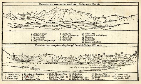 click to enlarge click to enlargeRG0105.jpg "1 Swarth Fell 2 Stile End 3 Winter Crag 4 Dow Crag in Hartsop 5 Hallen Fell 6 Place Fell 7 Stone Cross Pike 8 Dolly Waggon Pike / Birk Fell (below) 9 High Spine How / The Knotts (below) 10 Helvellyn 11 Cachety Cam 12 Glenridding Dodd 13 Helvellyn Low Man 14 Herring Pike 15 Keppel Cove Head 16 Raise 17 Gowbarrow 18 Greenside 19 Glencoin Fell 20 Soulby Fell" On p.162 in the Red Guide guide book, Guide to the English Lakes. item:- JandMN : 102.6 Image © see bottom of page |
|
|
|
||
| evidence:- | outline view:- placename:- Dunmallet |
|
| source data:- | Print, hand coloured engraving, Lower Reach, Ullswater from Pooley Bridge, Westmorland
and Cumberland, published by Sherwood and Co, London, 1836?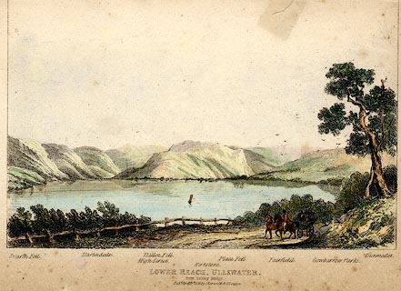 click to enlarge click to enlargePR0371.jpg Objects in the view are identified by a caption at the bottom - Swarth Fell, Martindale, High Street, Hallen Fell, Kirkstone, Place Fell, Fairfield, Gowbarrow Parks, Dumallet. printed at bottom:- "LOWER REACH, ULLSWATER. / from Pooley Bridge. / Pubd. April 15th 1836 by Sherwood &Co London." item:- Dove Cottage : 2008.107.371 Image © see bottom of page |
|
|
|
||
 BMY29.jpg (taken 2.11.2006) |
||
|
|
||
| hearsay:- |
Do you agree with William Gilpin:- |
|
| "... rather a disgusting object. Shaped with conical exactness; planted uniformly with
Scotch firs; and cut as uniformly into walks verging to a centre, it becomes a vile
termination of a noble scene ..." |
||
|
|
||
Lakes Guides menu.