 Garnett 1850s-60s SD38


|

|
|
|
gazetteer links places may or may not be labelled on the map |
||

|
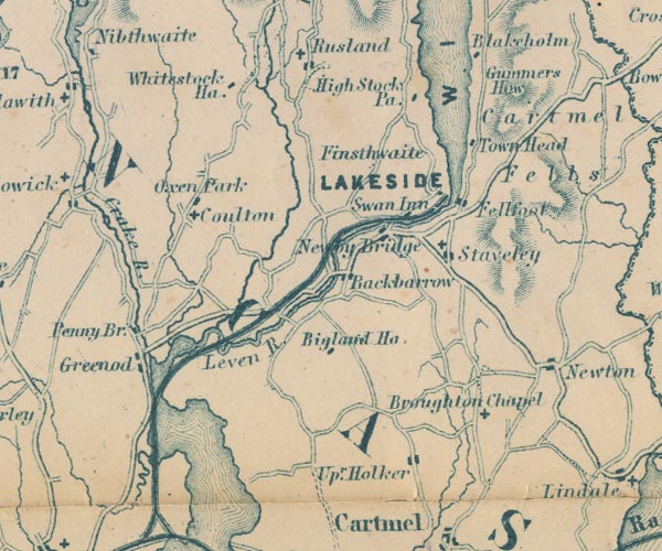
-- Backbarrow -- "Backbarrow" |
|
|
|
-- Beck Side -- "Upr. Holker" |
|
|
|
-- Bigland Hall -- "Bigland Ho." |
|
|
|
-- Cartmel Fell -- "Cartmel Fells" |
|
|
|
-- Colton -- "Coulton" |
|
|
|
-- Crake, River -- "Crake R." |
|
|
|
-- Fell Foot -- "Fellfoot" |
|
|
|
-- Finsthwaite -- "Finsthwaite" |
|
|
|
-- Greenodd -- "Greenod" |
|
|
|
-- Gummer's How -- "Gummers How" |
|
|
|
-- High Stott Park -- "High Stock Pa." |
|
|
|
-- Holy Trinity Church |
|
|
|
-- Lakeside branch railway |
|
|
|
-- Lakeside -- "LAKESIDE" |
|
|
|
-- Leven, River -- "Leven R." |
|
|
|
-- Newby Bridge -- "Newby Bridge" |
|
|
|
-- Oxen Park -- "Oxen Park" |
|
|
|
-- Penny Bridge -- "Penny Br." |
|
|
|
-- Rusland Pool |
|
|
|
-- Rusland -- "Rusland" |
|
|
|
-- St Mary's Church |
|
|
|
-- St Peter's Church -- "Broughton Chapel" |
|
|
|
-- Staveley-in-Cartmel -- "Staveley" |
|
|
|
-- Swan Hotel -- "Swan Inn" |
|
|
|
-- Town Head -- "Town Head" |
|
|
|
-- Whitestock Hall -- "Whitestock Ha." |
|
|
|
-- Windermere lake -- "WINDER MERE" |
|
|
civil parishes The area roughly includes parts of parishes:- Cartmel Fell Lower Allithwaite Broughton East Haverthwaite Colton Lowick Hawkshead Egton with Newland Staveley-in-Cartmel Upper Allithwaite Windermere Satterthwaite |
||
|
|
||
|
|
Lakes Guides menu. | |