 Old Cumbria Gazetteer
 |
 |
|
| Newby Bridge, Newby Bridge | ||
| Newby Bridge | ||
| site name:- | Leven, River | |
| locality:- | Newby Bridge | |
| civil parish:- | Staveley-in-Cartmel (formerly Lancashire) | |
| civil parish:- | Colton (formerly Lancashire) | |
| civil parish:- | Windermere (formerly Westmorland) | |
| county:- | Cumbria | |
| locality type:- | bridge | |
| coordinates:- | SD36918636 | |
| 1Km square:- | SD3686 | |
| 10Km square:- | SD38 | |
|
|
||
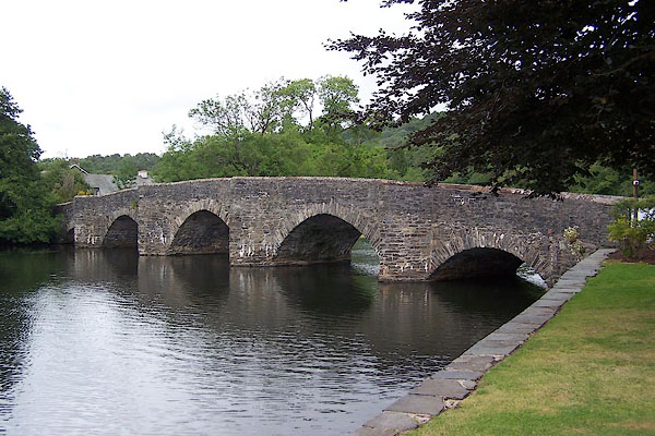 BJR22.jpg (taken 5.8.2005) |
||
|
|
||
| evidence:- | old map:- OS County Series (Wmd 41 6) placename:- Newby Bridge |
|
| source data:- | Maps, County Series maps of Great Britain, scales 6 and 25
inches to 1 mile, published by the Ordnance Survey, Southampton,
Hampshire, from about 1863 to 1948. OS County Series (Lan 8 14) |
|
|
|
||
| evidence:- | old map:- Saxton 1579 placename:- New Bridge |
|
| source data:- | Map, hand coloured engraving, Westmorlandiae et Cumberlandiae Comitatus ie Westmorland
and Cumberland, scale about 5 miles to 1 inch, by Christopher Saxton, London, engraved
by Augustinus Ryther, 1576, published 1579-1645.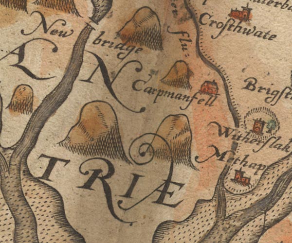 Sax9SD38.jpg "New bridge" Over River Leven at foot of Windermere. item:- private collection : 2 Image © see bottom of page |
|
|
|
||
| evidence:- | old map:- Speed 1611 (Wmd) placename:- Newe Bridge |
|
| source data:- | Map, hand coloured engraving, The Countie Westmorland and
Kendale the Cheif Towne, scale about 2.5 miles to 1 inch, by
John Speed, 1610, published by George Humble, Popes Head Alley,
London, 1611-12.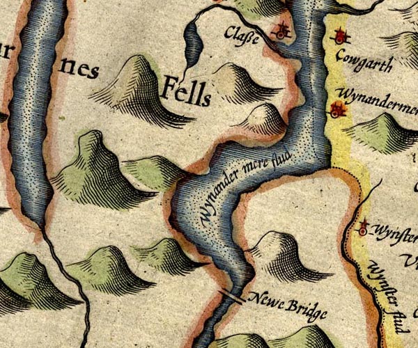 SP14SD39.jpg "Newe Bridge" double line across the Leven item:- Armitt Library : 2008.14.5 Image © see bottom of page |
|
|
|
||
| evidence:- | old map:- Sanson 1679 |
|
| source data:- | Map, hand coloured engraving, Ancien Royaume de Northumberland
aujourdhuy Provinces de Nort, ie the Ancient Kingdom of
Northumberland or the Northern Provinces, scale about 9.5 miles
to 1 inch, by Nicholas Sanson, Paris, France, 1679. click to enlarge click to enlargeSAN2Cm.jpg double line over a stream; bridge item:- Dove Cottage : 2007.38.15 Image © see bottom of page |
|
|
|
||
| evidence:- | old map:- Seller 1694 (Wmd) |
|
| source data:- | Map, hand coloured engraving, Westmorland, scale about 8 miles
to 1 inch, by John Seller, 1694. click to enlarge click to enlargeSEL7.jpg two lines cross a stream; bridge item:- Dove Cottage : 2007.38.87 Image © see bottom of page |
|
|
|
||
| evidence:- | old map:- Morden 1695 (Cmd) placename:- Newbridge |
|
| source data:- | Map, uncoloured engraving, Cumberland, scale about 4 miles to 1
inch, by Robert Morden, 1695, published by Abel Swale, the
Unicorn, St Paul's Churchyard, Awnsham, and John Churchill, the
Black Swan, Paternoster Row, London, 1695-1715.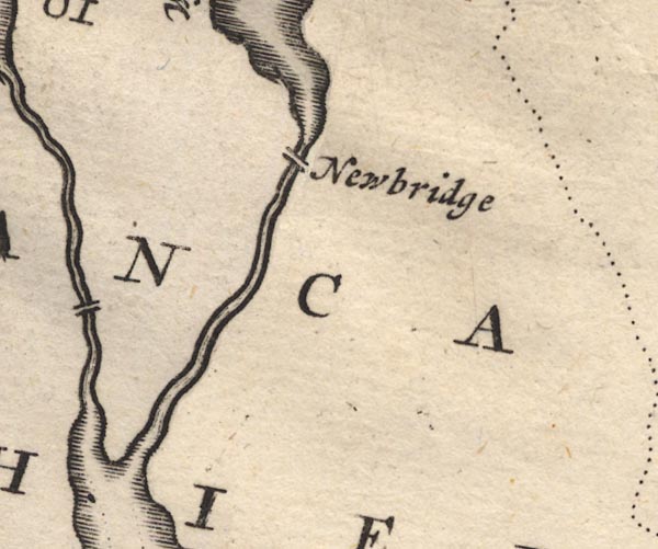 MD12SD38.jpg "Newbridge" Double line over a stream. item:- JandMN : 90 Image © see bottom of page |
|
|
|
||
| evidence:- | old map:- Morden 1695 (Wmd) placename:- New Bidge |
|
| source data:- | Map, hand coloured engraving, Westmorland, scale about 2.5 miles to 1 inch, by Robert
Morden, published by Abel Swale, the Unicorn, St Paul's Churchyard, Awnsham, and John
Churchill, the Black Swan, Paternoster Row, London, 1695.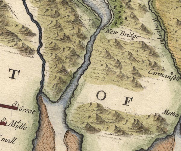 MD10SD38.jpg "New Bidge" Double line over a stream. item:- JandMN : 24 Image © see bottom of page |
|
|
|
||
| evidence:- | descriptive text:- Defoe 1724-26 placename:- North Bridge |
|
| source data:- | Tour through England and Wales, by Daniel Defoe, published in
parts, London, 1724-26. "The great Winander Mere, ... extends it self on the west side [of Westmorland] for twelve miles and more, reckoning from North Bridge on the south, where it contracts it self again into a river ..." |
|
|
|
||
| evidence:- | descriptive text:- Simpson 1746 placename:- North Bridge |
|
| source data:- | Atlas, three volumes of maps and descriptive text published as
'The Agreeable Historian, or the Compleat English Traveller
...', by Samuel Simpson, 1746. goto source goto sourcePage 1021:- "It [Winander Mere] extends itself like a Sea on the West Side from North-bridge on the South, where it contracts itself again into a River to Gresmere North." |
|
|
|
||
| evidence:- | probably old map:- Simpson 1746 map (Wmd) placename:- New Bridge |
|
| source data:- | Map, uncoloured engraving, Westmorland, scale about 8 miles to 1
inch, printed by R Walker, Fleet Lane, London, 1746.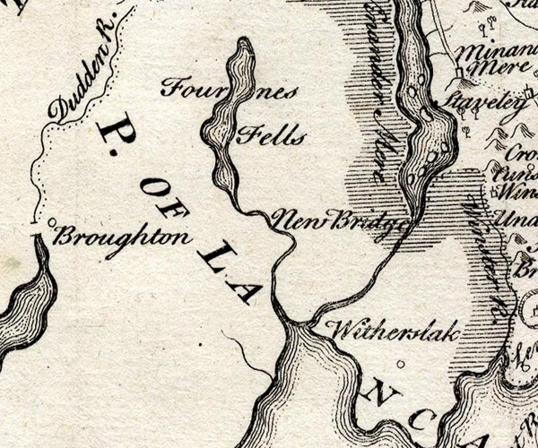 SMP2SDJ.jpg "New Bridge" Nothing is marked. item:- Dove Cottage : 2007.38.59 Image © see bottom of page |
|
|
|
||
| evidence:- | descriptive text:- West 1778 (11th edn 1821) placename:- Bewby Bridge |
|
| source data:- | Guide book, A Guide to the Lakes, by Thomas West, published by
William Pennington, Kendal, Cumbria once Westmorland, and in
London, 1778 to 1821. goto source Page 26, footnote:- "... from Kendal to the above-named Bewby-bridge (sic) ... is about 13 miles. ..." |
|
|
|
||
| evidence:- | old map:- Crosthwaite 1783-94 (Win/Ble) placename:- Newby Bridge |
|
| source data:- | Map, uncoloured engraving, An Accurate Map of the Grand Lake of
Windermere, scale about 2 inches to 1 mile, by Peter
Crosthwaite, Keswick, Cumberland, 1783, version published 1819. CT9SD38T.jpg "Newby Bridge" double line over the River Leven item:- Armitt Library : 2008.14.102 Image © see bottom of page |
|
|
|
||
| evidence:- | old map:- West 1784 map placename:- Newby Bridge |
|
| source data:- | Map, hand coloured engraving, A Map of the Lakes in Cumberland,
Westmorland and Lancashire, scale about 3.5 miles to 1 inch,
engraved by Paas, 53 Holborn, London, about 1784. Ws02SD38.jpg item:- Armitt Library : A1221.1 Image © see bottom of page |
|
|
|
||
| evidence:- | old text:- Clarke 1787 |
|
| source data:- | Guide book, A Survey of the Lakes of Cumberland, Westmorland,
and Lancashire, written and published by James Clarke, Penrith,
Cumberland, and in London etc, 1787; published 1787-93. goto source Page 152:- "... Newby Bridge, where is ... an handsome stone bridge across the stream which flows from the Lake ..." |
|
|
|
||
| evidence:- | old map:- Clarke 1787 map (Windermere S) placename:- Newbery Bridge |
|
| source data:- | Map, A Map of the Southern Part of the Lake Winandermere and its
Environs, scale about 6.5 ins to 1 mile, by James Clarke,
engraved by Samuel John Neele, 352 Strand, published by James
Clarke, Penrith, Cumberland and in London etc, 1787.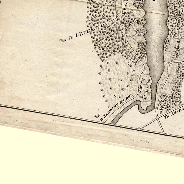 CLBSD38T.jpg Labelling a road:- "To NEWBERY BRIDGE" item:- private collection : 10.11 Image © see bottom of page |
|
|
|
||
| evidence:- | old print:- Wilkinson 1810 (plate 10) placename:- Newby Bridge |
|
| source data:- | Print, uncoloured soft ground etching, Newby Bridge, foot of Winandermere, Lancashire,
by Joseph Wilkinson, engraved by William Frederick Wells, published by R Ackermann,
Repository of Arts, 101 Strand, London, 1810.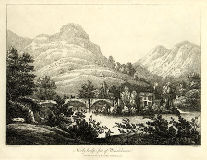 click to enlarge click to enlargeWKN110.jpg Plate 10 in Select Views in Cumberland, Westmoreland, and Lancashire. printed at bottom left, right, centre:- "Revd. Jos: Wilkenson delt. / W. F. Wells sc. / Newby bridge, foot of Winandermere. / Published Sepr. 1. 1810. by R. Ackermann. 101. Strand. London." item:- Fell and Rock Climbing Club : MN4.10 Image © see bottom of page |
|
|
|
||
| evidence:- | old map:- Ford 1839 map placename:- Newby Bridge |
|
| source data:- | Map, uncoloured engraving, Map of the Lake District of
Cumberland, Westmoreland and Lancashire, scale about 3.5 miles
to 1 inch, published by Charles Thurnam, Carlisle, and by R
Groombridge, 5 Paternoster Row, London, 3rd edn 1843.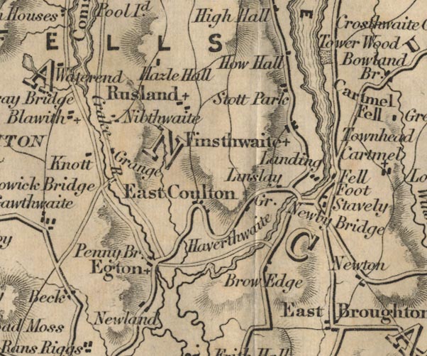 FD02SD38.jpg "Newby Bridge" Road across stream. item:- JandMN : 100.1 Image © see bottom of page |
|
|
|
||
| evidence:- | old map:- Garnett 1850s-60s H placename:- Newby Bridge |
|
| source data:- | Map of the English Lakes, in Cumberland, Westmorland and
Lancashire, scale about 3.5 miles to 1 inch, published by John
Garnett, Windermere, Westmorland, 1850s-60s.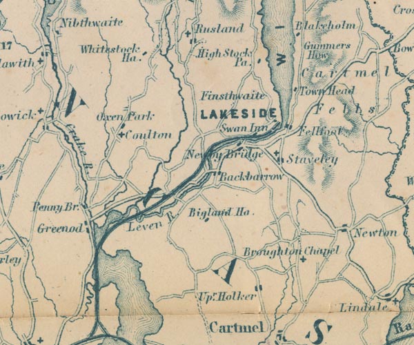 GAR2SD38.jpg "Newby Bridge" road crosses stream item:- JandMN : 82.1 Image © see bottom of page |
|
|
|
||
| evidence:- | old print:- Payn 1867 placename:- Newby Bridge |
|
| source data:- | Print, uncoloured engraving, Newby Bridge, Staveley-in-Cartmel, Lancashire, by T L
Aspland, published by J Garnett, Windermere, Westmorland, 1867.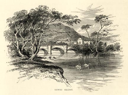 click to enlarge click to enlargePN0310.jpg On p.18 of The Lakes in Sunshine, text by James Payn. item:- Fell and Rock Climbing Club : 184.10 Image © see bottom of page |
|
|
|
||
| evidence:- | old map:- Prior 1874 map 1 placename:- Newby Bridge |
|
| source data:- | Map, uncoloured engraving or lithograph? Winander Mere, scale
about 2.5 miles to 1 inch, published by John Garnett,
Windermere, Westmorland, 1874. click to enlarge click to enlargePI03M1.jpg "Newby Bridge" double line over a stream item:- private collection : 133.1 Image © see bottom of page |
|
|
|
||
| evidence:- | old photograph:- Bell 1880s-1940s |
|
| source data:- | Photograph, black and white, Newby Bridge, on the River Leven, Staveley-in-Cartmel,
Lancashire, by Herbert Bell, photographer, Ambleside, Westmorland, 1890s.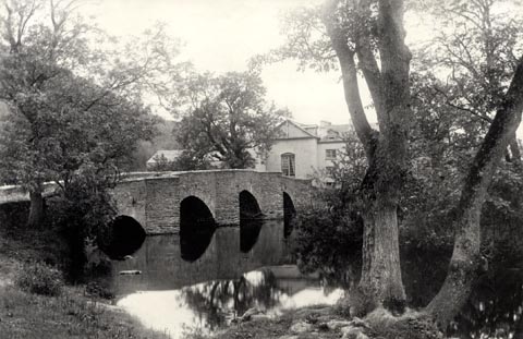 click to enlarge click to enlargeHB0911.jpg item:- Armitt Library : ALPS586 Image © see bottom of page |
|
|
|
||
| evidence:- | old photograph:- Bell 1880s-1940s item:- reflections |
|
| source data:- | Photograph, black and white, Newby Bridge, River Leven, Staveley-in-Cartmel, Lancashire,
by Herbert Bell, photographer, Ambleside, Westmorland, 1890s.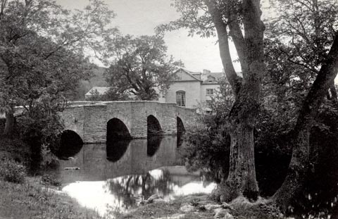 click to enlarge click to enlargeHB0652.jpg stamped on reverse:- "HERBERT BELL / Photographer / AMBLESIDE" item:- Armitt Library : ALPS315 Image © see bottom of page |
|
|
|
||
| evidence:- | old print:- Heaton Cooper 1905 (edn 1908) placename:- Newby Bridge |
|
| source data:- | Print, colour halftone, A Misty Morning, Newby Bridge, Staveley-in-Cartmel, Lancashire,
from a watercolour painting by Alfred Heaton Cooper, published by Adam and Charles
Black, London, 2nd edn 1908.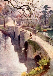 click to enlarge click to enlargeHC0101.jpg Frontispiece to The English Lakes, painted by Alfred Heaton Cooper, described by William T Palmer. printed at tissue opposite the print:- "A MISTY MORNING, NEWBY BRIDGE, WINDERMERE" printed at signed lower left:- "[A HEATON COOPER]" item:- JandMN : 468.1 Image © see bottom of page |
|
|
|
||
| evidence:- | old print:- Heaton Cooper 1905 (edn 1908) placename:- Newby Bridge |
|
| source data:- | Print, colour halftone, Swan Inn, Newby Bridge, Staveley-in-Cartmel, Lancashire, from
a watercolour painting by Alfred Heaton Cooper, published by Adam and Charles Black,
London, 2nd edn 1908.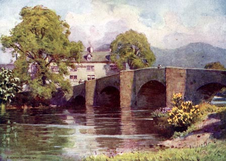 click to enlarge click to enlargeHC0104.jpg Opposite p.12 of The English Lakes, painted by Alfred Heaton Cooper, described by William T Palmer. printed at tissue opposite the print:- "SWAN INN, NEWBY BRIDGE, WINDERMERE" printed at signed lower left:- "[A HEATON COOPER]" item:- JandMN : 468.4 Image © see bottom of page |
|
|
|
||
| evidence:- | illustration:- LNWR 1910 |
|
| source data:- | Print, colour lithograph? Newby Bridge, Windermere, from a
painting by R T Roussel, published by the London and North
Western Railway, LNWR, about 1910.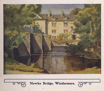 click to enlarge click to enlargeNW01E3.jpg Included in the guide book, The English Lakes, published by the London and North Western Railway about 1910. Roussel, R T, 1910item:- JandMN : 49.4 Image © see bottom of page |
|
|
|
||
| evidence:- | database:- Listed Buildings 2010 placename:- Newby Bridge |
|
| source data:- | courtesy of English Heritage "NEWBY BRIDGE / / / STAVELEY IN CARTMEL / SOUTH LAKELAND / CUMBRIA / II[star] / 421934 / SD3690186359" |
|
| source data:- | courtesy of English Heritage "Bridge over river Leven. Date uncertain, repaired in C17. Stone rubble with limestone coping. Long narrow bridge with 5 segmental arches stepped up to centre, triangular cutwaters between rise to form refuges to both sides." |
|
|
|
||
| evidence:- | old print:- Pearson 1900s placename:- Newby Bridge |
|
| source data:- | Print, halftone photograph, Newby Bridge, Foot of Windermere, Staveley-in-Cartmel,
Lancashire, published by C Arthur Pearson, Henrietta Street, London, 1900s.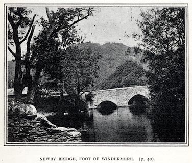 click to enlarge click to enlargePS1E17.jpg On p.37 of Pearson's Gossipy Guide to the English Lakes and Neighbouring Districts. printed at bottom:- "NEWBY BRIDGE, FOOT OF WINDERMERE. (p.40)." item:- Armitt Library : A1188.24 Image © see bottom of page |
|
|
|
||
| hearsay:- |
Built 1652, replacing a wooden bridge. |
|
|
|
||
Lakes Guides menu.