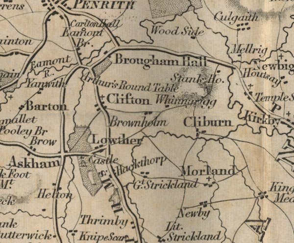
 Ford 1839 map NY52


|

|
|
|
gazetteer links places may or may not be labelled on the map |
||

|
-- Arthur's Round Table -- "Arthur's Round Table" |
|
|
|
-- Ash Hill Cottages -- "Stank Ho." |
|
|
|
-- Askham -- "Askham" |
|
|
|
-- Brown Howe -- "Brownholm" |
|
|
|
-- Cliburn -- "Cliburn" |
|
|
|
-- Clifton -- "Clifton" |
|
|
|
-- Culgaith -- "Culgaith" |
|
|
|
-- Eamont Bridge -- "Eamont Br." |
|
|
|
-- Great Strickland -- "Gt. Strickland" |
|
|
|
-- Hackthorpe -- "Hackthorp" |
|
|
|
-- Helton -- "Helton" |
|
|
|
-- Lowther Castle -- "Castle" |
|
|
|
-- Lowther -- "Lowther" |
|
|
|
-- Millrigg -- "Mellrig" |
|
|
|
-- Morland -- "Morland" |
|
|
|
-- Newby -- "Newby" |
|
|
|
-- Appleby to Penrith -- "P to B 20 Ms." |
|
|
|
-- Shap to Penrith -- "S to P 11 Ms." |
|
|
|
-- Whinnyrigg -- "Whinnarigg" |
|
|
|
-- Woodside -- "Wood Side" |
|
|
civil parishes The area roughly includes parts of parishes:- Penrith Dacre Askham Barton Sockbridge and Tirril Langwathby Sleagill Little Strickland Culgaith Newby Thrimby Lowther Great Strickland Cliburn Morland Bampton Clifton Yanwath and Eamont Bridge Brougham |
||
|
|
||
|
|
Lakes Guides menu. | |