 Jenner 1643

|

|
|
|
map type:- Jenner 1643 |
|
|
|
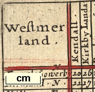
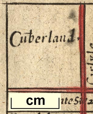
Table of distances with a map, Westmerland, scale about
16 miles to 1 inch, and Cumberland, scale about 21 miles to
1 inch, published by Thomas Jenner, London, 1643; published
1643-80.
The map is tucked into the triangular space at the bottom right of the table of distances. Published in 'A DIRECTION FOR the English TRAVILLER By which he Shal be inabled to Coast about all England and Wales. And also to know how farre any Market or noteable Towne in any Shire lyeth one from an other and Whether the same be East, West, North, or South from ye Shire Towne. As also the distance betweene London and any other Shire or great towne with the scituation thereof East, West, North, or South from London. By the help also of this worke one may know (in What Parish, Village or Mansion house soever he be in) What Shires he is to passe through & which way he is to travell till he comes to his journies End. / Infaelix cuius nulli Sapientia prodest / Are to be sold by Thomas Jenner at the South entrance of the Exchange 1643. Jacob van Langeren sculp:' 1643. The book has a distance table for all the shire towns in England along with a map of the country; there are entirely new thumbnail county maps at about twice the scale of the Simmons 1635 maps; many of the new maps are rotated to fit the available space better; Westmorland is rotated about 45 degrees anticlockwise to fit its space. Published in 'A Book of The Names of all the Hundreds contained in the Shires of the Kingdom of England; Together with the Number of the Towns, Parishes, Villages, and Places of every Hundred: if you desire to know the Names of Places contained in any Hundred look into the book of the Shire Mapps of England, and near or about the Town which the Hundred is named by lyeth the parishes, Villages, & Places that are in the Hundred. Usefull for Quartermasters, Brief-Gatherers, and all such as have to doe the Shires of England. London, Printed for Thomas Jenner, and are to be sold at the Royal Exchange, 164[ ].' 1644? Only one copy of the 1644 edition of the book is known (Skelton 1970). Published by John Garrett at the south entrance of the Royal Exchange, London, 1645. Published in 'A Book of the Names of All Parishes, Market Towns, Villages, Hamlets, and smallest Places, in England and Wales. Alphabetically set down, as they be in every Shire. With the names of the Hundreds in which they are, and how many Towns there are in every Hundred ... A Work very necessary For Traveilers, Quartermasters, Gatherers of Breefs, Strangers, Carriers, and Messengers with Letters, and all others that know the name of the place, but can neither tell where it is, nor how to goe unto it. If you would find out any Shire, note that the Shires lie Alphabetically, beginning with Barkshire, and so following accordingly. Summa cuique virtus pulcherima merces. London: printed by M. S. for Tho: Jenner, at the South entrance of the Royal Exchange, 1657.' In the 1657 edition the tables of distances and maps are the same as the 1643 edition but arranged with the map at the top, the list of hundreds might continue onto the reverse and other pages; the book size is 4 1/4 x 6 5/8 ins. The 1657 edition is published again 1662 and twice in 1668. Published in 'A Book of the Names of all Parishes, Market Towns, Villages, Hamblets, and Smallest Places, in England and Wales ... Together with a Catalogue of the Market Towns, castles, Parish Churches, Rivers, Forrests and Parks; and also the Length, Breadth and Circumference of every particular Shire ... London, Printed by S. S. for John Garret, at his Shop as you up the Stairs of the Royal Exchange in Cornhil: where is also sold all sorts of large and small Maps of the World, or any particular part thereof, with variety of Prospect Cities, 1677.' The 1677 is a reprint of the 1668 edition, with all its different pagination etc. Published in 'A Direction for the English Traviller. ... Printed and are to be sold By John Garrett, at the South entrance of ye Royal Exchange in Cornhill, where you may have a most exact Mapp of England with the small Townes described in six large Sheets, also other large Mapps of ye World or any part thereof', 1680. |
||

|
Simons 1635 | |
|
(map example JandMN (8))
|
||
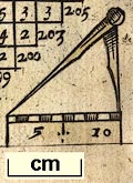
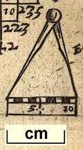
| map feature:- | up is NE & scale line & compasses & rivers & lakes & relief & hillocks & county & settlements | |
| inscription:- |
printed plain cartouche, upper left
Westmer / land. |
|
| scale line:- | 10 miles = 15.6 mm | |
| scale:- | 1 to 1000000 ? (1 to 1031631 from scale line) | |
| wxh, sheet:- | 12x15cm | |
|
||
|
||
| references:- |
Jenner, Thomas: 1643: Direction for the English Traviller:
Jenner, Thomas (London) Garrett, John: 1677 & 1680: Direction for the English Traviller: Garrett, John (London) Jenner, Thomas: 1657 & 1662 & 1668: Book of the Names of all Parishes, Market Towns, Villages, Hamlets, ...: Jenner, Thomas (London) Jenner, Thomas: 1677: Book of the Names of all Parishes, Market Towns, Villages, Hamblets, ...: Garrett, John (London) Fordham, H G, Sir: 1924: Roadbooks and Itineraries of Great Britain, 1570-1850: (Cambridge) Keuning, J: 1956: van Langeren Family, The: Imago Mundi: 13: pp.101-09 |
|
| sources:- |
Chubb 1927 (XLVI) Curwen 1918 Skelton 1970 JandMN Collection Box Collection Wordsworth Trust Collection Armitt Library Kendal Library Maps |
|
| items seen (illustrated items in bold):- | ||
|
|
Armitt Library : ALMC2008.14.98 -- table of distances -- Westmerland | |
|
|
Dove Cottage : 2007.38.84 -- table of distances -- Westmerland | |
|
|
Dove Cottage : 2007.38.85 -- table of distances -- Westmerland | |
|
|
Dove Cottage : 2007.38.86 -- table of distances -- Cumberland | |
|
|
JandMN (8) -- table of distances -- Westmerland | |
|
|
Kendal Library : Map 65 -- table of distances -- Westmerland | |
|
|
private collection (52_Cmd) -- table of distances -- Cumberland | |
|
|
private collection (52_Wmd) -- table of distances -- Westmerland | |