 Jenner 1643

|

|
|
|
item:- Dove Cottage : 2007.38.84 image:- © see bottom of page |
click to enlarge |
|
|
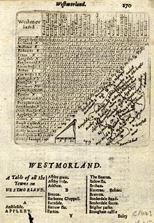
Table of distances with map and list of places,
uncoloured engraving, Westmerland ie Westmorland, scale
about 16 miles to 1 inch, engraved by Jacob van Langeren,
published by Thomas Jenner, London, 1643, edn 1668-77?
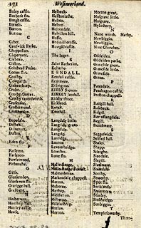
Probably from A Book of the Names of All Parishes, Market Towns, Villages, Hamlets, and smallest Places, in England and Wales, 1668. The map is tucked into the triangular space at the bottom right of the table of distances. A list of towns begins below and continues on the reverse. |
||

|
Jenner 1643 | |
| map feature:- | up is NE & scale line & dividers & rivers & lakes & relief & hillocks & county & settlements & road distances (?) | |
| inscription:- |
printed plain cartouche, upper left
Westmer / land. |
|
| scale line:- | 10 miles = 15.4 mm | |
| scale:- | 1 to 1000000 ? (1 to 1045029 from scale line) | |
| wxh, sheet:- | 13x18cm | |
|
||