 Jenner 1643

|

|
|
|
item:- Armitt Library : ALMC2008.14.98 image:- © see bottom of page |
click to enlarge |
|
|
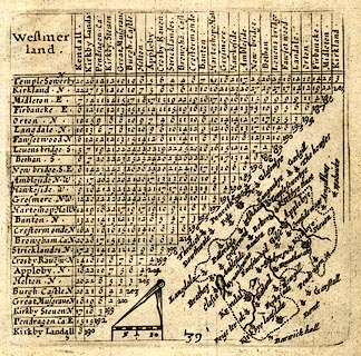
Table of distances, with map, uncoloured engraving,
Westmerland ie Westmorland, scale about 16 miles to 1 inch,
engraved by Jacob van Langeren, published by Thomas Jenner,
Cornhill, London, 1643.
The map is tucked into the triangular space at the bottom right of the table of distances. Published in A Direction for the English Travailler. |
||

|
Jenner 1643 | |
| map feature:- | up is NE & scale line & dividers & rivers & lakes & relief & hillocks & county & settlements & road distances (?) | |
| inscription:- |
printed plain cartouche, upper left
Westmer / land. |
|
| scale line:- | 10 miles = 15.2 mm | |
| scale:- | 1 to 1100000 ? (1 to 1058779 from scale line) | |
| wxh, sheet:- | 13.5x17.5cm | |