 Greenwood 1824

|

|
|
|
map type:- Greenwood 1824 |
|
|
|
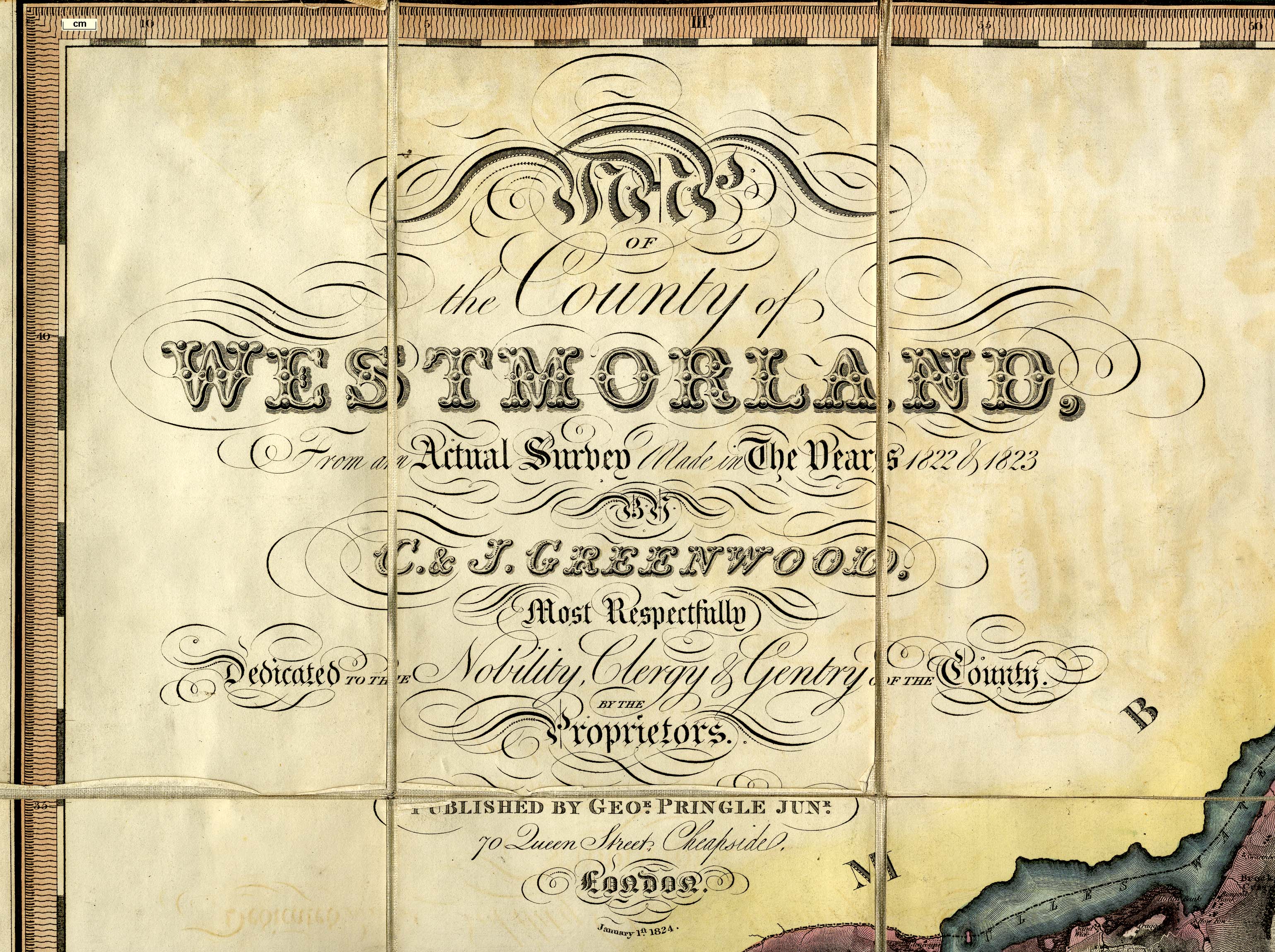
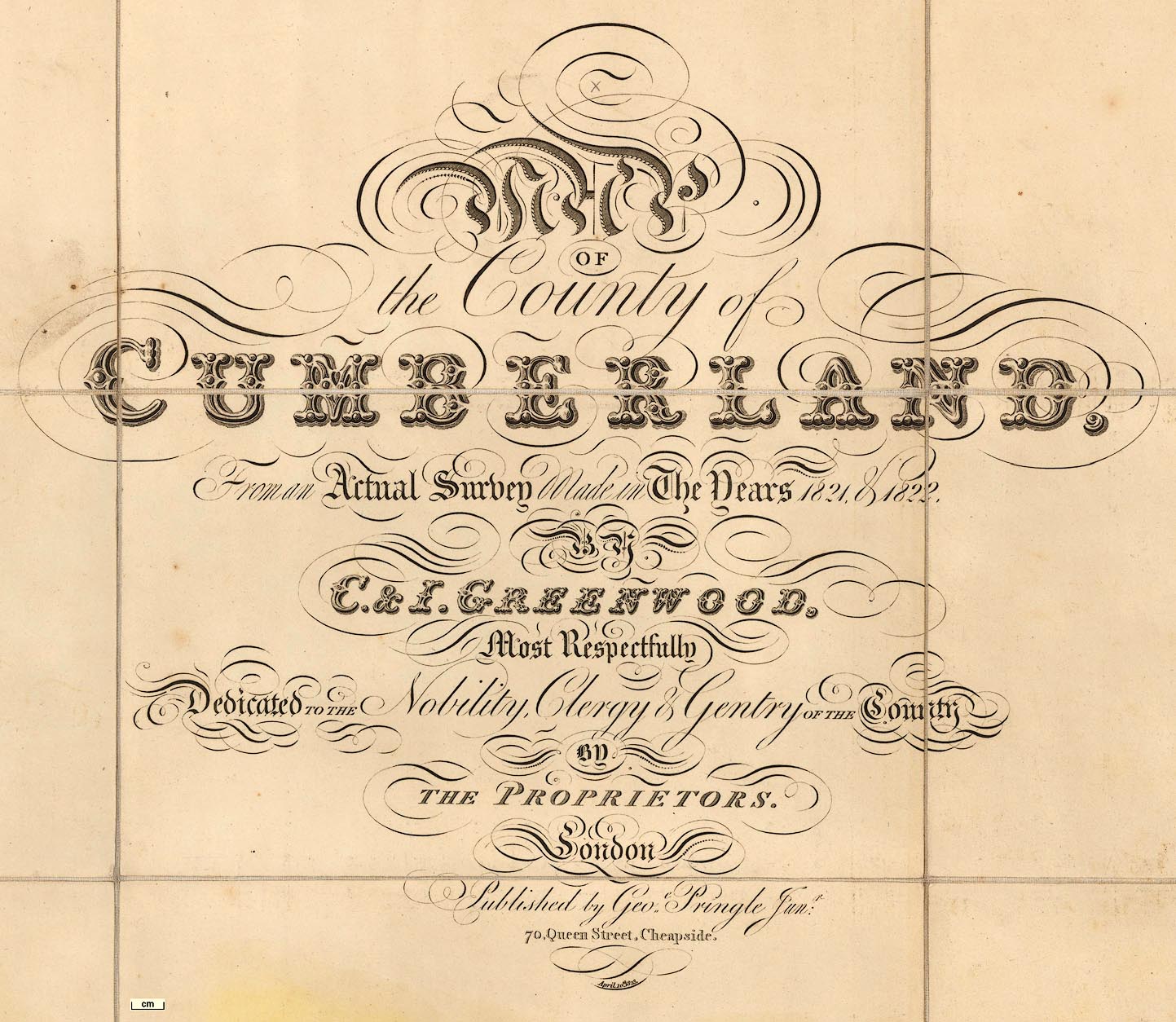
Maps, Map of the County of Westmorland, scale about 1
inch to 1 mile, and Map of the County of Cumberland, scale
about 1 inch to 1 mile, etc, by C and J Greenwood, published
by George Pringle jnr, 70 Queen Street, Cheapside, London,
1823 and 1824 respectively.
There are corresponding maps of Lancashire whose parts north of the sands are relevant to Cumbria, and of other counties. Reduced versions of the maps were published in an atlas, 1834. Published again, Cumberland 1842, Westmorland 1836 and 1844. |
||

|
Greenwood 1834 | |
| map feature:- | sectioned for folding (8x4 pieces) & mounted & folded & slip case (like a leather full bound book) & vignettes (lower right, VIEW OF APPLEBY) & table of symbols & compass rose & up is N & scale line & lat and long scales (trapezoid projection, includes 2d 7m to 3d 11m W, 54d 10m to 54d 43m N) & sea plain & coast form lines & rivers & lakes & relief & hill hachuring (fairly successful impression of the shape of the county) & woods & trees & forests & parks & county & wards (hundreds) & settlements & roads & turnpike roads & road distances & canals | |
| inscription:- |
printed upper left
MAP / OF / the County of / WESTMORLAND, / from an Actual Survey Made in the Years 1822 & 1823 / By / C. & J. GREENWOOD. / Most Respectfully / Dedicated TO THE Nobility, Clergy & Gentry OF THE County. / BY THE / Proprietors. / PUBLISHED BY GEOE. PRINGLE JNR. / 70 Queen Street, Cheapside, / London. / January 1st. 1824. |
|
| inscription:- |
printed above scale line
SCALE OF STATUTE MILES. |
|
| wxh, folded:- | 15x25.5cm | |
| wxhxd, slip case:- | 18x25.5x3.5cm | |
| wxh, sheet:- | 120.5x101cm | |
| wxh, map (including gaps):- | 1134x997mm | |
| scale:- | 1 to 65000 ? (1 to 65188 from scale line assuming a statute mile) | |
| scale line:- | 7+1 miles = 197.5 mm (approx) | |
| inscription:- |
printed bottom border
West Longitude from Greenwich |
|
| Longitude, Kendal:- | 2 d 44 3/4 m W | |
|
||

|
||

|
||
|
||
| sources:- |
Armitt Library National Library of Scotland Kendal Record Office Barrow Record Office Carlisle Library Maps Rodger 1972 |
|
| items seen (illustrated items in bold, * have map segments):- | ||
|
|
Armitt Library : A1824 -- map -- Map of the County Palatine of Lancashire * | |
|
|
Armitt Library : A1827 -- map -- Map of the County of Westmorland * | |
|
|
BarrowRO : BDX/209 (1) -- map -- Map of the County Palatine of Lancashire | |
|
|
Carlisle Library : Map 3 -- map -- Map of the County of Cumberland | |
|
|
Kendal Library : Map 148 -- map -- Map of the County of Westmorland | |
|
|
KendalRO : WDX 22 -- map -- Map of the County of Westmorland | |
|
|
KendalRO : WDX 740 -- map -- Map of the County of Westmorland | |
|
|
National Library of Scotland : EME.b.3.11 -- map -- Map of the County of Cumberland * | |
|
|
National Library of Scotland : EME.b.3.55 -- map -- County of Westmoreland | |