 Bowen and Kitchen 1760

|

|
|
|
map type:- Bowen and Kitchin 1760 |
|
|
|
New Map of the Counties of Cumberland and Westmoreland,
scale about 4 miles to 1 inch, by Emanuel Bowen and Thomas
Kitchin, published by T Bowles, John Bowles and Son, Robert
Sayer, and John Tinney, 1760; published 1760-87.
One of a series of county maps by Bowen and Kitchin, published by John Hinton, King's Arms, St Paul's Churchyard, London, from 1751; the series was begun 1749. John Tinney took over from 1753, and the series was completed 1760; it continued in editions to 1787. also see Lancashire, North Riding of Yorkshire, and West Riding of Yorkshire, to cover all modern Cumbria. Published in 'The Large English Atlas: Or, A New Set Of Maps Of All The Counties In England And Wales, Drawn From The Several Surveys which have been hitherto Published: Viz. ... Laid Down On A Large Scale, And containing all the Cities, Towns, Villages, and Churches, whether Rectories or Vicarages, Chapels, many Noblemen's and Gentlemen's Seats, &c. &c. Each Map Is Illustrated With a General Description of the County, its Cities, Borough and Market Towns, the Number of Members returned to Parliament, of Parishes, Houses, Acres of Land, &c. And Historical Extracts relative to the Trade, manufactures, and Government of the Cities and Principal Towns, and the present State of their Inhabitants, &c. By Emanuel Bowen, Geographer to His Majesty, Thomas Kitchin, and Others. London: Printed and Sold by T. Bowles, in St. Paul's Church-Yard; John Bowles and Son, at the Black Horse, in Cornhill; John Tinney, at the Golden Lion, and Robert Sayer, at the Buck, both in Fleet-Street.' 1760. The atlas size is 17 1/2 x 23 ins; the map is plate 35 but not numbered; the space round the county boundary filled with notes; there is a coat of arms of Sir James Lowther of Lowther; its size is 20 1/2 x 27 1/2 ins. The imprint is for R Sayer, T Bowles, J Bowles and Son, J Tinney. An earlier edition of the atlas of this series does not have the Cumberland and Westmorland map. This were issued with the 1760 edition, as reported in the Public Advertiser, 22 May 1760, 'Three Maps, being the last which compleats the Set of the Counties of England, which have for been for some Years about, and published as they were finished.' The new maps are engraved better than the earlier maps. Published in another edition 'The Large English Atlas ... Printed and Sold by T. Bowles ... John Bowles and Son ... and Robert Sayer ...' about 1762. A plate number is added, 35. The imprint is for R Sayer, T Bowles, J Bowles and Son. Published in another edition 'The Large English Atlas ... Drawn From The Several Surveys which have been hitherto Published. With three general Maps of England, Scotland and Ireland, From the best and latest Authorities. ... London: Printed and Sold by T. Bowles, in St. Paul's Church-Yard; John Bowles, at the Black Horse, in Cornhill; and Robert Sayer, at the Buck, in Fleet-Street,' about 1763. John imprint is for R Sayer, T Bowles and J Bowles. The plate number is now 37. Published in another edition 'The Large English Atlas ... London: Printed and Sold by John Bowles, at the Black Horse, in Cornhill; Carington Bowles, next the Chapter House, in St. Paul's Church-Yard, and Robert Sayer, at the Buck, in Fleet-Street,' about 1764. Published in another edition 'The Large English Atlas ... Printed and Sold by Carington Bowles, Map and Print Seller, at No.69, in St. Paul's Church-Yard. MDCCLXVII.' ie 1767. Published in another edition 'The Large English Atlas ... Printed and Sold by Robert Sayer, Map and Printseller, at No 53, in Fleet-Street.' or 'Le Grand Atlas Anglois: Ou, Nouveau Receuil Des Cartes De Toutes Les Provinces D'Angleterre Et De La Principaute De Galles, ... Chez Robert Sayer, Marchand de Cartes & d'Etampes dans Fleet-Street, No.53.' about 1767. Published in another edition 'The Large English Atlas ... Printed and Sold by Robert Wilkinson, at No.58, in Cornhill, Successor to Mr. John Bowles, deceased.' about 1779. Published in another edition 'The Large English Atlas ... By Emanuel Bowen ... Thomas Kitchin, and Others. London: Printed and Sold by Robert Wilkinson, at No.58, in Cornhill, Successor to Mr. John Bowles, deceased.' about 1785. Published in 'The Large English Atlas: ... Drawn From The Several Surveys Hitherto Published. To which are added, a Map of the Country 35 miles round London, a Plan of London and Westminster, and general Maps of Scotland and Ireland, From the latest and best Authorities. The Whole Engraved on 50 Copper Plates ... Laid Down On A Large Scale ... By Emanuel Bowen, Thomas Kitchin, Captain Andrew Armstrong, and Others. London. Printed for Robert Sayer, Map, Chart, And Printseller, No.53, Fleet-Street. MDCCLXXXVII.' ie 1787. The map was issued, bound in an atlas or loose, by Bowles and Carver, Laurie and Whittle, and Robert Wilkinson, from 1790s-1820s. The imprint is for R Wilkinson, Laurie and Whittle, and Bowles and Carver. The map was published in a reduced form in the Royal English Atlas, about 1764. |
||
|
(example map Armitt Library : ALMC2008.14.10)
|
||
| map feature:- | baroque cartouche & dedication & descriptive text & table of symbols & up is N & scale line & lat and long scales (W from London, trapezoidal projection) & lat and long grid & sea plain & coast form lines & rivers & bridges & lakes & relief & hill hachuring & woods & forests & trees & parks & wards (hundreds) & settlements & roads & road distances | |
| inscription:- |
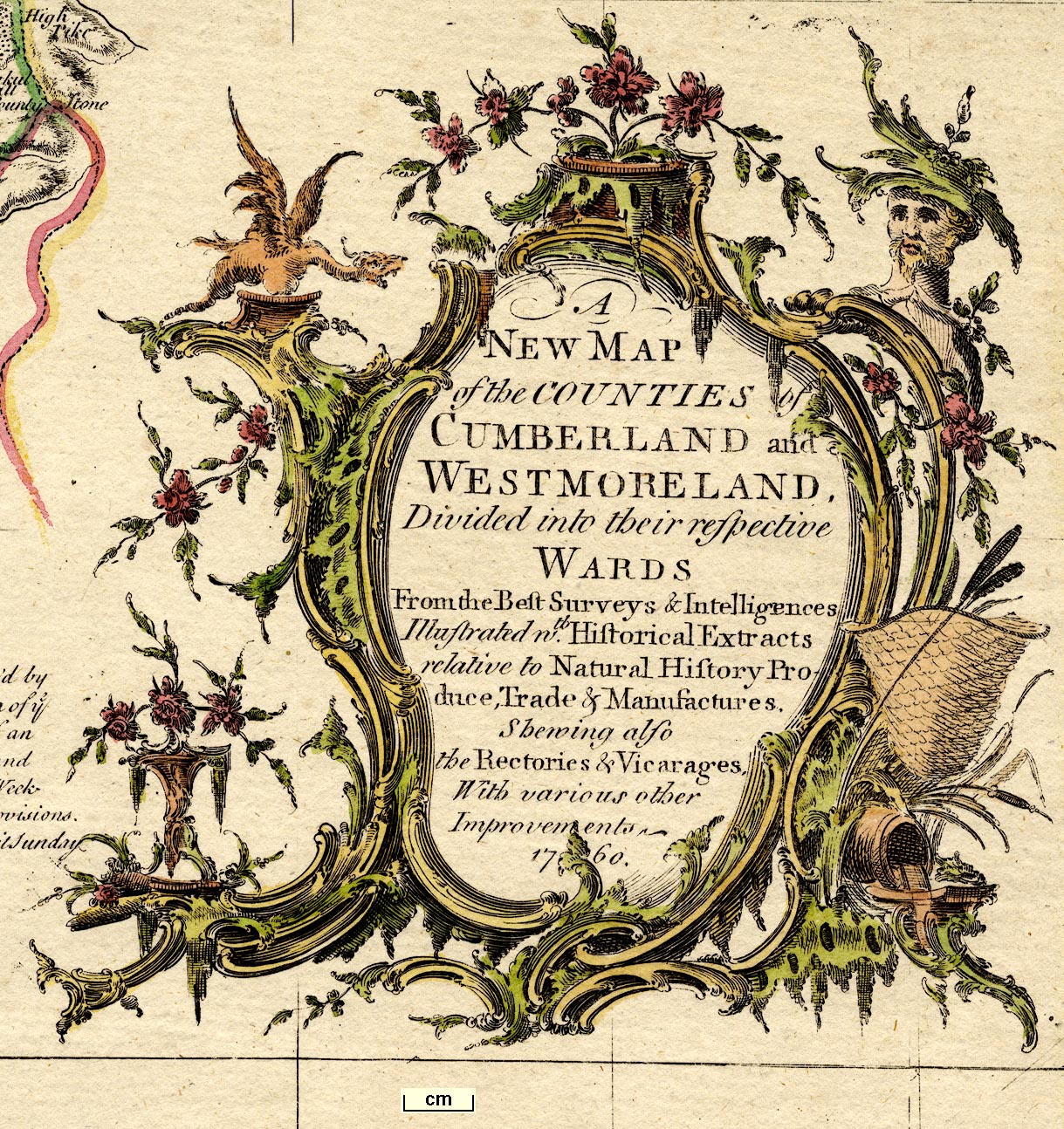
printed baroque cartouche, lower right
A / NEW MAP / of the COUNTIES of / CUMBERLAND and / WESTMORELAND. / Divided into their respective / WARDS / From the Best Surveys & Intelligencies / Illustrated wth. Historical Extracts / relative to Natural History Pro- / duce, Trade & Manufactures. Shewing also / the Rectories & Vicarages, / With various other / Improvements / 1760. |
|
| inscription:- |
printed bottom
Printed for T. Bowles in St. Pauls Church Yard, Robt. Sayer, [ ] in Fleet Street, & John Bowles [ ] in Cornhil. (with parts erased) |
|
| inscription:- |
printed baroque cartouche, upper left
To the Honble. / Sr. James Lowther / of Lowther / in WESTMORELAND, Bart. / Lieutenant & Custos Rotulorum / of Westmoreland / and Lieutenant of CUMBERLAND / This MAP is humbly Inscrib'd |
|
| wxh, sheet:- | 57.5x76.6cm | |
| wxh, plate:- | 545x703mm | |
| wxh, map:- | 521x681mm | |
| inscription:- |
printed above scale line
British Statute Miles 69 1/2 to a Degree |
|
| scale line:- | 20 miles = 133.9 mm | |
| scale:- | 1 to 240000 ? (1 to 240380 from scale line wrongly assuming a statute mile) | |
| longitude, Kendal:- | 2d 51m W | |
|
||
| references:- |
Bowen, Emanuel & Kitchin, Thomas: 1760: Large English Atlas
& New Set of Maps of all the Counties of England and Wales:
Bowles, T & Bowles, John and Son & Tinney, John & Sayer,
Robert (London) Bowen, Emanuel & Kitchin, Thomas: 1763 (?): Large English Atlas & New Set of Maps of all the Counties of England and Wales: Bowles, John & Bowles, T & Sayer, Robert (London) Bowen, Emanuel & Kitchin, Thomas: 1764 (?): Large English Atlas & New Set of Maps of all the Counties of England and Wales: Bowles, John & Bowles, Carington & Sayer, Robert (London) Bowen, Emanuel & Kitchin, Thomas: 1767 (?): Large English Atlas & New Set of Maps of all the Counties of England and Wales: Bowles, Carington (London) Bowen, Emanuel & Kitchin, Thomas: 1767 (?): Large English Atlas & New Set of Maps of all the Counties of England and Wales & Grand Atlas Anglois & Nouveau Receuil des Cartes de Toutes les Provinces d'Angleterre et de la Principaute de Galles: Sayer, Robert (London) Bowen, Emanuel & Kitchin, Thomas: 1779 (?): Large English Atlas & New Set of Maps of all the Counties of England and Wales: Wilkinson, Robert (London) Bowen, Emanuel & Kitchin, Thomas & Armstrong, Andrew: 1787: Large English Atlas: & New Set of Maps of all the Counties of England and Wales: Sayer, Robert (London) |
|
| sources:- |
Chubb 1927 (CXCVI) Hodson 1984 Wordsworth Trust Collection Armitt Library private collection Kendal Library Maps Carlisle Library Maps |
|
| items seen (illustrated items in bold):- | ||

|
Armitt Library : ALMC2008.14.10 -- map -- New Map of the Counties of Cumberland and Westmoreland | |
|
|
Carlisle Library : Map 288 -- map -- New Map of the Counties of Cumberland and Westmoreland | |
|
|
Chetham's Library (1) -- map -- Accurate Map of the County of Lancaster | |
|
|
Dove Cottage : 2007.38.27 -- map -- New Map of the Counties of Cumberland and Westmoreland | |
|
|
Dove Cottage : 2007.38.28 -- map -- New Map of the Counties of Cumberland and Westmoreland | |
|
|
Kendal Library : Map 140 -- map -- New Map of the Counties of Cumberland and Westmoreland | |
|
|
private collection (153) -- map -- Accurate Map of the West Riding of Yorkshire | |
|
|
private collection (154) -- map -- Accurate Map of the North Riding of Yorkshire | |
|
|
private collection (221) -- map -- Accurate Map of the County of Lancaster | |