 Bowen and Kitchin 1760

|

|
|
|
item:- Armitt Library : ALMC2008.14.10 image:- © see bottom of page |
click to enlarge |
|

|
detail menu | |
|
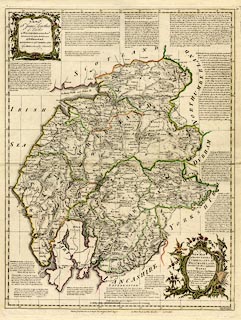
Map, hand coloured engraving, A New Map of the Counties
of Cumberland and Westmoreland Divided into their Respective
Wards, scale about 4 miles to 1 inch, by Emanuel Bowen and
Thomas Kitchin et al, published by T Bowles, Robert Sayer,
and John Bowles, London, 1760.
The imprint at the bottom has names deleted, perhaps John Tinney and 'and Son' from John Bowles. The map was first published in the Large English Atlas, 1760, whose origins go back to 1749. This version of the map probably comes from the 1785 edition. The map has a dedication to Sir James Lowther. |
||
|
|
Bowen and Kitchin 1760 | |
| map feature:- | baroque cartouche & dedication & descriptive text & table of symbols & up is N & scale line & lat and long scales (W from London, trapezoidal projection) & lat and long grid & sea plain & coast form lines & rivers & bridges & lakes & relief & hill hachuring & woods & forests & trees & parks & wards (hundreds) & settlements & roads & road distances | |
| inscription:- |
printed baroque cartouche, lower right
A / NEW MAP / of the COUNTIES of / CUMBERLAND and / WESTMORELAND. / Divided into their respective / WARDS / From the Best Surveys & Intelligencies / Illustrated wth. Historical Extracts / relative to Natural History Pro- / duce, Trade & Manufactures. Shewing also / the Rectories & Vicarages, / With various other / Improvements / 1760. |
|
| inscription:- |
printed bottom
Printed for T. Bowles in St. Pauls Church Yard, Robt. Sayer, [ ] in Fleet Street, & John Bowles [ ] in Cornhil. (with parts erased) |
|
| inscription:- |
printed baroque cartouche, upper left
To the Honble. / Sr. James Lowther / of Lowther / in WESTMORELAND, Bart. / Lieutenant & Custos Rotulorum / of Westmoreland / and Lieutenant of CUMBERLAND / This MAP is humbly Inscrib'd |
|
| inscription:- |
printed above scale line
British Statute Miles 69 1/2 to a Degree |
|
| scale line:- | 20 miles = 133.9 mm | |
| longitude, Kendal:- | 2d 51m W | |
| scale:- | 1 to 240000 ? (1 to 240380 from scale line wrongly assuming a statute mile) | |
| wxh, sheet:- | 57.5x76.6cm | |
| wxh, plate:- | 545x703mm | |
| wxh, map:- | 521x681mm | |
|
|
notes | |