 Bowen and Kitchin 1760

|

|
|

|
back to object record | |
| MAP FEATURES | ||
|
|
||
|
title cartouche
baroque cartouche map maker publisher |
Printed in a baroque cartouche, lower right:-
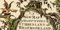
A NEW MAP of the COUNTIES of CUMBERLAND and WESTMORELAND. Divided into their respective WARDS From the Best Surveys & Intelligencies Illustrated wth. Historical Extracts relative to Natural History Produce, Trade & Manufactures. Shewing also the Rectories & Vicarages, With various other Improvements 1760. Printed at the bottom:- Printed for T. Bowles in St. Pauls Church Yard, Robt. Sayer, [ ] in Fleet Street, & John Bowles [ ] in Cornhil. The imprint at the bottom has names deleted, perhaps John Tinney and 'and Son' from John Bowles. |
|
|
|
||
| dedication |
Printed upper left in a baroque cartouche is a
dedication:-
To the Honble. Sr. James Lowther of Lowther in WESTMORELAND, Bart. Lieutenant & Custos Rotulorum of Westmoreland and Lieutenant of CUMBERLAND This MAP is humbly Inscrib'd |
|
|
|
||
| table of symbols |
Printed lower centre is an:-
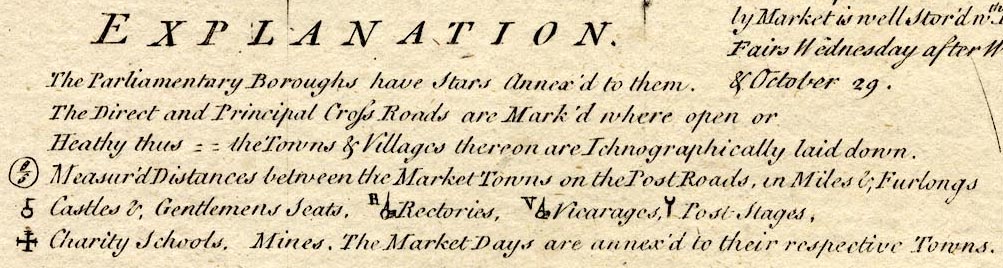
EXPLANATION. The Parliamentary Boroughs have Stars Annex'd to them. The Direct and Principal Cross Roads are Mark'd where open or Heathy [double line, dotted] the Towns & Villages thereon are Ichnographically laid down. [circle enclosing 8/5] Measur'd Distances between the Market Towns on the Post Roads, in Miles & Furlongs. [circle, post and flag] Castles & Gentlemens Seats, [circle, building and tower R] Rectories, [circle, building and tower V] Vicarages, [post with a crescent atop] Post Stages, [cross potent] Charity Schools. Mines The Market Days are annex'd to their respective Towns. |
|
|
|
||
| descriptive text |
Printed in spare spaces on the map sheet are blocks of
descriptive text about the counties and various towns, etc.
The places described are:-
Ambleside Appleby Carlisle Cockermouth County of Cumberland County of Westmoreland Dunmail raise stones Eden, Picts Wall, etc Egremont Kendal Keswick Levens Bridge Milthrop [Milnthorpe] Penrith Winander Mere See:- BO18TXT.txt |
|
|
|
||
|
orientation
up is |
There is no indicator of orientation, but the map has a
graticule, a grid of latitude and longitude lines. The map
is printed with North at the top of the sheet.
|
|
|
|
||
|
scale
scale line |
Printed with the scale line:-

British Statute Miles 69 1/2 to a Degree chequered in miles to 5 then in fives; labelled 1 to 5 then 20. The 20 miles = 133.9 mm gives a map scale 1 to 240380. The map scale is about:- 1 to 240000 4 miles to 1 inch |
|
|
|
||
|
lat and long scales
lat and long grid |
Printed in the map borders are scales of latitude and longitude for a trapezoidal projection; chequered in degrees, labelled in tens. The bottom longitude scale is labelled:- Longitude West from London. Measuring from the scales the:- longitude, Kendal = 2d 51m W Kendal is 2d 45m W. It looks as if the map's prime meridian is 6 minutes East of Greenwich, which is unlikely. Looking at other features on this map does not encourage trust in its accuracy, so this estimate of the prime meridian can be ignored. |
|
|
|
||
|
sea area
sea plain |
The sea areas are plain. Some sea areas are labelled,
eg:-
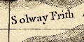
Solway Frith now Eden R. Moricambe IRISH SEA |
|
|
|
||
|
coast line
coast form lines foreshore headlands |
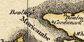
The coast line is emphasized by form lines which may be overlaid by dotting indicating foreshore sands. One area of sands is labelled:- Burr Sand just south of Seascale. The extensive sands in the Kent and Leven estuaries are not shown; Duddon Sands are.*COMMENT3 Headlands are recognizable, only two are labelled:- Boulness St. Bees Head |
|
|
|
||
|
rivers
bridges |
Rivers are drawn by drawn by a double line with stream
lines, tapering to a single wiggly line tapering upstream.
Some rivers are labelled, eg:-
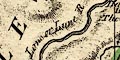
Lone or Lune R. Can R. Blenkeynbeck R. Labelled south of Levens Bridge is:- Waterfall copied from other maps; no waterfall here. Bridges are implied where a road crosses and interrupts a stream, and might be marked elsewhere by a double line across a stream as at Nether Wasdale or at Dalston. 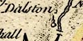
Most bridges are not labelled, although some names are implied by a settlement name. A few bridges are labelled, eg:- Nether Bridge [in Kendal] Burrow Bridge [Low Borrow Bridge] Levens Bridge The last is mentioned in a descriptive text. |
|
|
|
||
| lakes |
Lakes are drawn by an outline with form lines. Some lakes are labelled:- Coniston Mere Broad Water [Ennerdale Water] Broad Water [Hawes Water] Haws Water [Hayeswater] Ulles Lake [Ullswater] Wiborn Water [Thirlmere] Winander Mere Other lakes or tarns might be recognized, eg:- Bleaberry Tarn Burnmoor Tarn Buttermere lake Crummock Water Derwent Water Devoke Water Easedale Tarn Grasmere lake Grisedale Tarn Kentmere Tarn Loweswater lake Rydal Water Wast Water |
|
|
|
||
|
relief
|
Hill hachuring is used to indicate relief. Although some valleys are successfully, if gently, shown, the overall mountainous nature of the region is not. Some hill areas are labelled, eg:- Derwent Fells Mountains Hard Knot Hill Skiddaw |
|
|
|
||
|
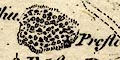
wood
trees forests |
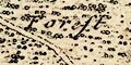
Woodland is suggested by groups of tree and bush symbols. Some of the forest areas are labelled, eg:- Englewood Forest Martendale Forest |
|
|
|
||
| parks |
Parks are drawn by a ring of fence palings. A park might be labelled, eg:- Barton Park Holm Park or named by its great house, eg:- Preston Hall |
|
|
|
||
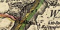
| county |
County boundaries are a dashed line, and are emphasized by a colour tint on the inside for each area, including adjacent counties; Westmorland green, Cumberland yellow, Lancashire red, Scotland red, Northumberland green, Durham blue, Yorkshire yellow:- 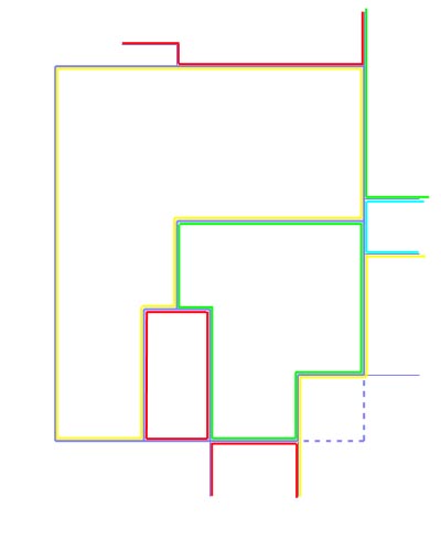
The county areas are labelled, eg:- WESTMORELAND CUMBERLAND |
|
|
|
||
| wards |
Ward boundaries are a lighter dashed line, emphasized by a colour tint on the inner side of each ward. The use of colours is not straightforward, or consistent. The county boundary colours have priority, but the rest of a ward has its own colour - for example Eskdale Ward tints are yellow where the border is the county boundary, and green for its internal boundary with other wards. Sometimes the ward and county tints are the same, as South Allerdale Ward. The too-clever scheme is given up for Westmorland where the ward boundaries are all tinted the same. A diagram might help:- 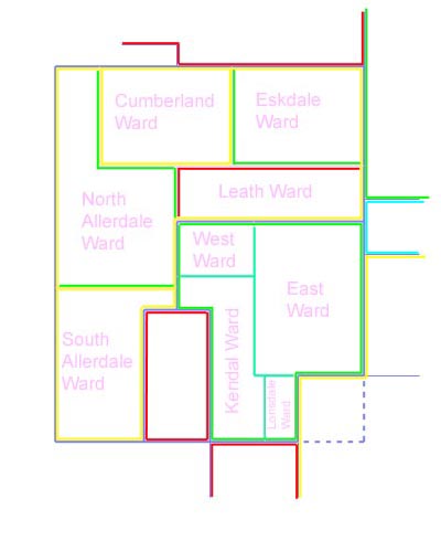
|
|
|
|
||
| settlements |
Settlements are marked by a circle with added elements,
or groups of blocks or shaded areas; further differentiated
by style of labelling. Symbols are explained in the table of
symbols.
|
|
|
cities
street plan market days |
blocks and shaded areas on a street plan with town walls;
labelled in upright block caps:-
CARLILE / Ma. Sat. V The market day is Saturday; there are two crosses potent for charity schools; V is for Vicarage. Notice the two suburbs outside the English Gate and Scotch Gate. |
|
|
towns
street plan market days electoral data |
blocks on a street plan 'ichnographically laid down';
labelled in upright lowercase text, eg:-
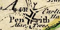
Penrith / Mar. Tues. / R Market day Tuesday; two crosses potent for charity schools; R is for Rectory; post and crescent symbol for a post stage. 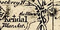
Kendal / Mar. Sat. Market day Saturday; notice the bridges and castle. APPLEBY / Mar. Sat. / V In upright block caps for its de jure status as county town; Market day Saturday; V for Vicarage; two stars for members sent to Parliament; notice the castle. |
|
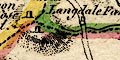
| villages |
circle, buildings and tower with a spire; labelled in
italic lowercase text, eg:-
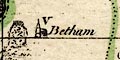
Betham / V Salkeld Magna / R V Vicarage; R Rectory. or blocks, if on a road, eg:- 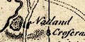
Natland |
|
| hamlets |
circle, small tower; labelled in italic lowercase text,
eg:-
Sleddale or circle and line, eg:- 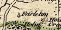
Farleton |
|
|
castles
houses |
circle, post and flag; labelled in italic lowercase text,
eg:-
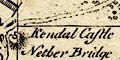
Kendal Castle |
|
|
|
||
|
roads
road distances post roads |
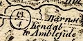
Roads are drawn by double line, solid or dotted. The table of symbols takes solid for granted but explains:- The Direct and Principal Cross Roads are Mark'd where open or Heathy [double line, dotted] the Towns & Villages thereon are Ichnographically laid down. Comparing the routes with present day roads and tracks there are some routes which are hard to believe. On the post roads a circle with figures gives:- Measur'd Distances between the Market Towns on the Post Roads, in Miles & Furlongs. Assuming the distances indicate which are post roads, they are:- from the south, Lancashire; 11'6 from Lancaster via Burton to Kendal, Westmorland; 26 to Penrith, a post stage, and 18'4 to Carlisle, Cumberland. from Kendal, 13'4 to Ambleside, Westmorland; 10'2 to Keswick, and 14'2 to Cockering ie Cockermouth, Cumberland. from Egremont, 14 to Cockermouth, 25 to Calisle, Cumberland. |
|
|
|
||
| miscellany | ||
|
|
||
|
antiquities
roman wall |
Hadrian's Wall is drawn by a double dotted line from
Boulness through Carlile, then east into Northumberland,
labelled:-
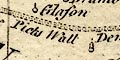
The Picts Wall Demolish'd |
|
|
|
||
|
antiquities
roman road |
A road NW across the corner of Cumberland about Spadeadam
Waste is labelled:-
The Maiden Way |
|
|
|
||
|
antiquities
roman forts |
SE of Kirkby Thore is a circle labelled:-
The Camp on Speedy More |
|
|
|
||
|
antiquities
earthworks |
A double ring west of Eamont Bridge is labelled:-
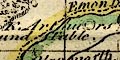
K. Arthurs Round Table |
|
|
|
||
|
antiquities
stone circles |
A group, perhaps a circle, of stones by the road S of
Shap is labelled:-
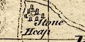
Stone Heap |
|
|
|
||
| stones |
At the meet of Westmorland, Cumberland and Yorkshire, SW
of Middleton, is:-
The County Stone Two standing stones are labelled:- Three Shire Stones upon Wry Nose Head One of the descriptive texts is about Dunmail Raise Stones. |
|
|
|
||
| crosses |
On the county boundary east of Pendragon is a cross:-
Hollow Mill Cross |
|
|
|
||
| beacons |
Labelled by a hill north of Isel is:-
Newton Beacon East of Orton is hill hachuring and label:- The Beacon |
|
|
|
||
|
mines
lead mines copper mines |
East of Knock are:-
Lead Mines and on Rumary Fell, SE of Dufton Pike:- Lead Mines both marked by dots. Beside Derwent Water, level with one of the islands, is labelled:- 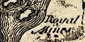
Royal Mines The german miners in the time of Elizabeth I had a base on Derwent Island. In the Newlands Valley is:- 
Copper Mines |
|
|
|
||
|
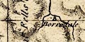
mines
black lead mines |
Around Watendlath in Borrowdale is labelled:-
Black Lead Mines They are not plotted at Seathwaite. |
|
Lakes Guides menu.