 Bowen and Kitchin 1760

|

|
|
|
item:- private collection (221) image:- © see bottom of page |
click to enlarge |
|
|
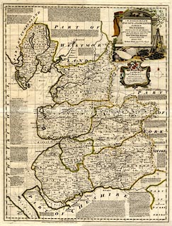
Map, hand coloured engraving, An Accurate Map of the
County of Lancaster, scale about 3.5 miles to 1 inch, by
Emmanuel Bowen, published by John Tinney, Golden Lyon, Fleet
Street, London, 1753.
Earlier published by John Hinton, Kings Arms, Newgate Street, London, 1752. Plate 21 in The Large English Atlas, 1760. |
||

|
Bowen and Kitchin 1760 | |
| map feature:- | pictorial cartouche (cotton spinning and weaving, coal mining) & dedication & compass rose & scale line & lat and long scales (rectangular projection) & lat and long grid (5x5 minutes) & sea plain & sandbanks & coast form lines & rivers & lakes & relief & hillocks & woods & forests & parks & county & hundreds & settlements & roads & descriptive text (includes lists of seats) | |
| inscription:- |
printed pictorial cartouche, upper right
An ACCURATE MAP of the / COUNTY of LANCASTER / Divided into its / HUNDREDS / Laid down from the best Authorities, / assisted by the most approved modern Maps & Charts / with various Extracts relative to its / Natural Produce, Trade, Manufactures / and present State of the / principal Towns. / By Eman : Bowen Geogr. to His Majesty. |
|
| inscription:- |
printed bottom
Sold by I. Tinney at the Golden Lyon in Fleetstreet London 1753 |
|
| inscription:- |
ms rev
21 plate number |
|
| scale line:- | 12 miles = 91.4 mm | |
| wxh, sheet:- | 61.5x80cm | |
| wxh, plate:- | 535x694mm | |
| wxh, map:- | 522x678mm | |
| scale:- | 1 to 210000 ? (1 to 211292 from scale line assuming a statute mile) | |
|
|
notes | |