 Bowen and Kitchin 1760

|

|
|
|
item:- private collection (153) image:- © see bottom of page |
click to enlarge |
|
|
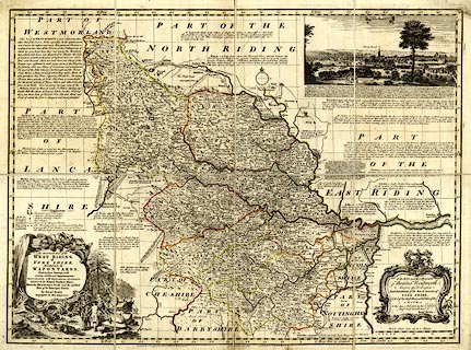
Map, hand coloured engraving, Accurate Map of the West
Riding of Yorkshire, scale about 4 miles to 1 inch, by
Emanuel Bowen, about 1750, published by Carington Bowles, St
Paul's Churchyard, by John Bowles, Cornhill, and by Robert
Sayer, Fleet Street, London, 1764.
Plate 43 in the Large English Atlas. |
||

|
Bowen and Kitchin 1760 | |
| map feature:- | sectioned for folding (4x2) & mounted & folded & card cover (board) & pictorial cartouche & dedication (Thomas Wentworth, Marquis of Rockingham) & vignettes (A View of Leeds) & descriptive text & table of symbols & compass rose & up is N & scale line & lat and long scales & lat and long grid (5 minutes) & rivers & lakes & relief & hillocks & woods & forests & parks & county & hundreds (wapontakes) & settlements & roads & post roads & roman roads & electoral data | |
| inscription:- |
printed title cartouche, lower left
An ACCURATE MAP of the / WEST RIDING / of / YORKSHIRE, / Divided into its / WAPONTAKES. / Drawn from Surveys, with / various additional Improvements : / ILLUSTRATED with HISTORICAL EXTRACTS / relative to its Natural Produce, Mines, / Minerals, Manufactures, Trade, and the present / state of its Principal Towns. / By Emanl. Bowen / Geographer to HIS MAJESTY. |
|
| inscription:- |
printed bottom
Printed for Carington Bowles in St. Pauls Church Yard [gap] John Bowles in Cornhil [gap] & Robt. Sayer in Fleet Street ammended from previous imprints |
|
| inscription:- |
embossed cover
BOWEN'S / WEST RIDING / 1750. ?whose cover |
|
| inscription:- |
printed with scale line
British Statue miles 69 to a Degree |
|
| scale line:- | 20 miles = 120.2 mm | |
| wxh, sheet:- | 75X56.5cm | |
| wxh, map (including gaps):- | 714x534mm | |
| scale:- | 1 to 270000 ? (1 to 267778 from scale line) | |