 Black 1841 map

|

|
|
|
map type:- Black 1841 map |
|
|
|
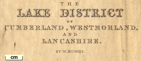
Map, The Lake District of Cumberland, Westmorland and
Lancashire, ie Cumbria, scale about 3.5 miles to 1 inch,
inserted in Black's Picturesque Guide to the Lakes,
published by Adam and Charles Black, North Bridge,
Edinburgh, Lothian, 1841. And 4 small maps of parts of the
Lake District:- Derwent Water and Bassenthwaite; Buttermere,
Crummock and Lowes Water; Winandermere, Coniston and
Grasmere; and Ulles Water; each about 1.5 to 2.5 miles to 1
inch.
The map might be amended in later editions. For instance the map in the 3rd edition, 1846, has railways corrected uptodate. |
||
| map feature:- | mounted & folded & up is N & scale line & sea plain & coast line & coast shaded & rivers & lakes & relief & hill hachuring & spot heights & beacons & forests & parks & county & settlements & roads & railways & canals | |
| inscription:- |
printed lower left
THE / LAKE DISTRICT / OF / CUMBERLAND, WESTMORLAND, / AND / LANCASHIRE. / BY W. HUGHES. |
|
| inscription:- |
printed bottom, centre and right
Edinburgh : Published by A & C Black / W. Hughes |
|
| inscription:- |
printed above scale line
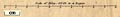
Scale of Miles : 69.14 to a Degree |
|
| scale line:- | 10 miles = 72.4 mm | |
| scale:- | 1 to 220000 ? (1 to 222285 from scale line) | |
| wxh, sheet:- | 37x48.5cm | |
| wxh, map:- | 347x463mm | |
|
||
|
||
| sources:- |
JandMN Collection Bicknell 1990 private collection Carlisle Library Maps |
|
| items seen (illustrated items in bold):- | ||

|
Carlisle Library : Map 79 -- map -- Lake District of Cumberland, Westmorland and Lancashire | |
|
|
Carlisle Library : Map 80 -- map -- Lake District of Cumberland, Westmorland and Lancashire | |
|
|
JandMN (32_1) -- map -- Lake District of Cumberland, Westmorland and Lancashire | |
|
|
JandMN (32_6) -- map -- Derwent Water and Bassenthwaite | |
|
|
JandMN (32_10) -- map -- Buttermere, Crummock and Lowes Water | |
|
|
JandMN (32_13) -- map -- Winandermere, Coniston and Grasmere | |
|
|
JandMN (32_14) -- map -- Ulles Water | |
|
|
Kendal Library : Map 161 -- map -- Lake District of Cumberland, Westmorland and Lancashire -- Plan of the Ruins of Furness Abbey | |
|
|
private collection (33) -- map -- Lake District of Cumberland, Westmorland and Lancashire -- Black's Travelling Map of the Lake District | |