 Black 1841 map

|

|
|
|
item:- JandMN (32_6) image:- © see bottom of page |
click to enlarge |
|
|
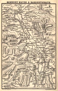
Map, Derwent Water and Bassenthwaite, Cumerland, scale
about 2 miles to 1 inch, by Sidney Hall, engraved by John
Bartholomew, Edinburgh, Lothian, about 1841.
Tipped in opposite p.73 of Black's Picturesque Guide to the English Lakes, published by Adam and Charles Black, North Bridge, Edinburgh, Lothian, 3rd edn 1846. |
||

|
Black 1841 map | |
| map feature:- | north point & up is N & scale line & rivers & lakes & relief & hill hachuring & settlements & roads | |
| inscription:- |
printed top
DERWENT WATER & BASSENTHWAITE. |
|
| inscription:- |
printed bottom, left and right
Drawn by Sidney Hall / Engd. by J. Bartholomew, Edinr. |
|
| scale line:- | 2+1 miles = 39.1 mm | |
| scale:- | 1 to 120000 ? (1 to 123479 from scale line) | |
| wxh, map:- | 89x140mm | |