 Black 1841 map

|

|
|
|
item:- private collection (33) image:- © see bottom of page |
click to enlarge |
|
|
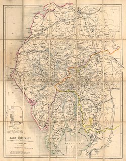
Map, Lake District of Cumberland, Westmorland and
Lancashire, scale about 3.5 miles to 1 inch, by W Hughes,
published by Adam and Charles Black, North Bridge,
Edinburgh, 1841; edn of 1860s?
Sectioned for folding, mounted, folded in a card cover. The map is altered from the 1841 edition; there are railways uptodate - Coniston Railway, Cockermouth, Keswick and Penrith Railway, Carlisle and Silloth Bay Railway, Kendal and Windermere Railway, Lancaster and Carlisle Railway, Maryport and Carlisle Railway, Newcastle and Carlisle Railway, Port Carlisle Dock and Railway, South Durham and Lancashire Union Railway, Ulverstone and Lancaster Railway, Whitehaven Junction Railway, Whitehaven and Furness Junction Railway; and there is a vignette plan of Furness Abbey. |
||

|
Black 1841 map | |
| map feature:- | mounted & folded & up is N & scale line & sea areas & sea plain & coast line & coast shaded & rivers & lakes & relief & hill hachuring & spot heights & beacons & forests & parks & county & settlements & roads & sands roads & railways & canals & vignettes | |
| inscription:- |
printed lower left
THE / LAKE DISTRICT / OF / CUMBERLAND, WESTMORLAND, / AND / LANCASHIRE. / BY W. HUGHES. |
|
| inscription:- |
printed bottom, centre and right
Edinburgh : Published by A & C Black / Drawn & Engraved by W. Hughes, 6, Brook Street, Holborn, London. |
|
| inscription:- |
printed above scale line
Scale of Miles : 69.14 to a Degree |
|
| inscription:- |
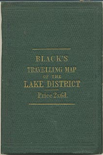
printed cover
BLACK'S / TRAVELLING MAP / OF THE / LAKE DISTRICT / Price 2s.6d. gold on green |
|
| scale line:- | 10 miles = 73.8 mm (approx) | |
| scale:- | 1 to 220000 ? (1 to 218068 from scale line) | |
| wxh, sheet:- | 41x50.5cm | |
| wxh, map (including gaps):- | 362x472mm | |
|
||
|
||
|
|
notes | |