 Black 1841 map

|

|
|

|
back to object record | |
| MAP FEATURES | ||
|
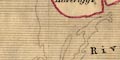
The map is altered from the 1841 edition, at the very least
there are added railways.
|
||
|
|
||
|
folded
mounted |
The map is mounted on linen and folded to fit in its
guidebook.
|
|
|
|
||
|
title
map maker engraver publisher |
Printed lower left:-
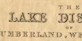
THE LAKE DISTRICT OF CUMBERLAND, WESTMORLAND, AND LANCASHIRE. BY W. HUGHES. Printed at the bottom, centre and right:- Edinburgh: Published by A & C Black / W. Hughes |
|
|
|
||
|
orientation
up is N |
The map is printed with North at the top of the
sheet.
|
|
|
|
||
|
scale line
scale |
Printed lower left is a:-
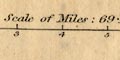
Scale of Miles: 69.14 to a Degree marked and labelled at mile intervals. The 10 miles = 72.4 mm gives a scale 1 to 222285; the map scale is about:- 1 to 220000 3.5 miles to 1 inch |
|
|
|
||
|
lat and long
lat and long scales lat and long grid |
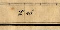
Printed in the map borders are scales of latitude and longitude for a conical projection; marked at 1 minute intervals, labelled at 10 minute intervals. The bottom scale is labelled:- Longitude West of Greenwich The map includes from 2d 32m to 3d 41m W, 54d 2m to 54d 57m N; the whole of the Lake counties, Cumberland, Westmorland, and Lancashire north of the sands. A graticule, a latitude and longitude grid, is drawn across the map at 10x10 minute intervals. |
|
|
|
||
| table of symbols |
Page vii of the preface to the guidebook has some
explanation of the map:-
MAP. The heights of the principal mountains in feet are annexed to their names. Bye-roads are marked thus ... [double line, dashed] Foot-roads and mountain tracks ... [single line, dashed] The line dividing counties ... [dotted line] The dotted lines beyond the coast line indicate the extent of sand dry at low water. Churches and chapels are marked with a cross ... [X cross] Waterfalls ... [3 lines across the stream's line] There are also notes on the maps itself, printed lower left:- 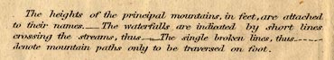
The heights of the principal mountains, in feet, are attached to their names.- The waterfalls are indicated by short lines crossing the streams, thus [line with 2 lines across] The single broken lines, thus [single dashed line] denote mountain paths only to be traversed on foot. |
|
|
|
||
|
sea area
sea plain |
The sea area is plain, with some areas labelled, eg:-
IRISH SEA Morecambe Bay Although not drawn as a shipping route, a line S by W from the estuary south of Ulverston is labelled:- Direction of Fleetwood 19 miles in direct distance from Ulverston |
|
|
|
||
|
coast line
coast shaded foreshore headlands lighthouses |
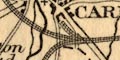
The coast line is emphasized by shading for a distance into the offing. Foreshore shallows, the great areas of sands in the southern estuaries, are outlined by a dotted line, the low water mark. Duddon Sands are labelled. Routes across the sands are shown. Headlands are noticed, for example:- Dubmill Point and St. Bees Head at which the cliffs are indicated by hill hachuring. Various islands off the Furness coast are clearly drawn and labelled, eg:- Walney I. Roe I. Sheep I. Some lighthouses are labelled:- Light House [circle, S end of Walney Island] Light House [square dot, St Bees Head] Cott Light [square dot, N of Silloth] |
|
|
|
||
|
rivers
bridges waterfalls |
River estuaries are drawn in some detail, and have the
coast shading. Rivers are then drawn by wiggly line tapering
inland; a large river might be drawn by a double line with
form lines, and islands, for example see the River Lune.
Some rivers are labelled, eg:-
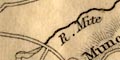
R. Mite River Duddon Wampool R. Troutbeck Riv. Eden The table of symbols says that waterfalls will be shown by 2 or 3 short lines across a stream's course. Examples can be seen at Rydal, labelled:- 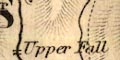
Upper Fall [2 lines] Lower Fall [3 lines] and around Skelwith:- Colwith Force Fall Bridges are implied where a road crosses and interrupts a stream. Some are labelled, eg:- Skelwith Br. Troutbeck Bridge |
|
|
|
||
| lakes |
Lakes and tarns are drawn in outline and shaded (like the
coast shading). On this copy of the map the more significant
lakes and tarns seem to be tinted, a delicate pale blue.
This appears to be original, or at least early tinting. At
some stage a heavier hand, perhaps an owner of the guide,
has clumsily tinted some lakes, mountain tops, and routes,
in blue.
Many lakes are labelled, eg:- 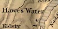
Hawes Water Windermere Thirlemere or Leathes water Crummock Blea Tarn Blelham Tarn |
|
|
|
||
|
relief
hill hachuring spot heights geology |
Relief is indicated by hill hachuring, with at least some
success in showing where the mountainous areas are, if not
their magnitude. Some summits, perhaps indicated by a ring
of hachures, perhaps tinted green, are labelled with a spot
height as well as a name, eg:-
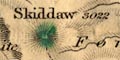
Skiddaw / 3022 Helvellyn / 3055 Sca Fell / 3100 Many other heights, outcrops, and upland areas are labelled, eg:- Branstree Great Dodd Harter Fell Furness Fells The Screes Valleys and dale heads might also be labelled, eg:- Mitterdale Long Sleddale Kirkstone Pass Wastdale Head Notice the crag south of Shap by the great road, labelled:- Wasdale Crag / granite I have found only one other geological comments on the map, a label:- Black Lead Mine near Seathwaite, by Honister. |
|
|
|
||
| beacons |
The names of two (maybe other?) hills suggest there past
use for a beacon fires:-
Penrith Beacon / 1020 [N of Penrith] Whinfell Beacon / 1500 [NW of Kendal] Though the problems were resolved by the mid 19th century, in earlier times there was a beacon system to warn of invading Caledonians. |
|
|
|
||
| forests |
Woodland is not generally indicated, but a forest area
might be labelled, eg:-
King's Forest of Geltsdale to the east of Carlisle, and:- Whinfell Forest Naddle Forest NB: 'forest' does not imply woodland. |
|
|
|
||
| parks |
A few parks are drawn in outline, with a dotted interior,
labelled by name or the name of a great house, eg:-
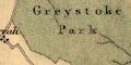
Greystoke Park Holker Hall Other areas are labelled, but not delineated, eg:- Gowbarrow Park |
|
|
|
||
| county |
County boundaries are a fine dotted line, tinted on this copy of the map with a colour on the inner side for each county; Westmorland yellow, Cumberland red, Lancashire green. The county areas are labelled, eg:- WESTMORLAND |
|
|
|
||
| settlements |
Settlements are marked by blocs or groups of blocks. In
some towns there is a suggestion of a street plan, for
example Carlisle, Ulverston, etc. A cross (+ cross) is used
to mark some churches or chapels, but this is done in a very
irregular way. Settlements are differentiated by size of
marking, and by style of lettering.
|
|
|
cities
towns |
group of blocks, perhaps a minimal street plan; labelled
in upright block caps, eg:-
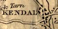
KENDAL CARLISLE CARTMEL |
|
|
villages
hamlets |
block or small group of blocks; labelled in italic, or
perhaps upright, lowercase text, eg:-
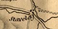
Staveley Long Sleddale [italic] Bowness [upright (Windermere)] Crosthwaite [italic] |
|
|
Upright and italic lowercase are used for other map
features.
|
||
|
|
||
| roads |
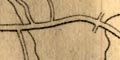
Roads are drawn by double lines. It is possible to see some differentiation, more major roads might be a little wider, and have one line slightly bolder (a convention for turnpike on some maps of this period). According to the table of symbols bye roads are double dashed lines, and mountain tracks are single dashed lines. For example follow the road up Longsleddale: to Sadgill it is a double solid line; from Sadgill over Gatescarth to Mardale Green, double dashed; 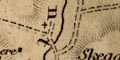
from Sadgill across to Kentmere valley, double dashed; from Kentmere across to Troutbeck, single dashed. However, notice the road from Mardale Green to Swindale, where there are dashed and solid parts, in black and grey? Roads across the sands are shown by double dashed line, east from Ulverston, and across Morecambe Bay from Kent's Bank to Hest Bank, labelled:- Road across the sands at Low Water |
|
|
|
||
| canals |
Canals are drawn by a single line, perhaps labelled. The
maps shows:-
|
|
| Lancaster Canal |
from Lancaster to Kendal; labelled:-
Lancaster Canal |
|
| Ulverston Canal |
from Ulverston to the coast; labelled:-
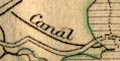
Canal |
|
| Carlisle Canal |
from Port Carlisle to Carlisle; labelled:-
Ship Canal |
|
|
|
||
| railways |
Railways are drawn by a triple line with cross lines, or by a single dashed line for routes being built. The map shows:- |
|
| Lancaster and Preston Junction Railway |
into Lancaster from the south; labelled:-
Lancaster & Preston Raily. Authorised 1837, opened 1840. |
|
| Lancaster and Carlisle Railway |
dashed line, from Lancaster, the route near Kendal,
through Shap, Penrith, to Carlisle; labelled:-
Lancaster & Carlisle Railway (in progress) Authorised 1844, opened 1846. |
|
| Newcastle and Carlisle Railway |
into Carlisle from the east; labelled:-
Newcastle and Carlisle Railway Authorised 1829, opened 1836. |
|
| Maryport and Carlisle Railway |
from Carlisle to Maryport; labelled:-
Maryport and Carlisle Railway Authorised 1837, opened 1845. |
|
| Whitehaven Junction Railway |
dashed line, from Maryport to Whitehaven; labelled:-
Whitehaven Railway (in progress) Authorised 1844, opened 1847. |
|
|
The dates of these railways implies that some of them
were added to the map after its initial publication in
1841.
Some railway stations are labelled separately from any settlement, eg:- Heath Field Statn. Hayton Station either side of Aspatria. |
||
|
|
||
| miscellaneous | ||
|
|
||
|
antiquities
henges |
A ring of small dots marks:-
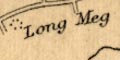
Long Meg & her Daughters by Addingham, south of Kirkoswald. Mayburgh is labelled, and the:- Druidical Circle west of Keswick. Etc. |
|
|
|
||
|
antiquities
roman sites roman forts |
The roman fort at Hardknot is labelled:-
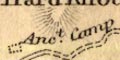
Anct. Camp |
|
|
|
||
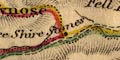
| stones |
Notice:-
Thorney Stone west of Heskett Newmarket. And:- Three Shire Stones at Wrynose. |
|
|
|
||
| stations |
Stations, ie suggested view points, are not generally
marked on this overall map. But:-
The Station where a house is built at the location of one of the viewpoints by Windermere, is marked and labelled. |
|
|
|
||
| inns |
Some inns are labelled, eg:-
Castle Inn Pheasant Inn at the north end of Bassenthwaite Lake. And:- The Swan north of Grasmere. Etc. |
|
|
|
||
| mines |
East of Honister Crag, by Seathwaite, is a:-
Black Lead Mine |
|
Lakes Guides menu.