 Black 1841 map

|

|
|
|
item:- JandMN (32_1) image:- © see bottom of page |
click to enlarge |
|
|
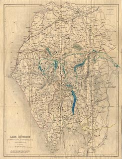
Map, Lake District of Cumberland, Westmorland and
Lancashire, scale about 3.5 miles to 1 inch, by W Hughes,
published by Adam and Charles Black, North Bridge,
Edinburgh, 1846.
Inserted on the reverse of the front cover of Black's Picturesque Guide to the English Lakes. The map is altered from the 1841 edition, at the very least there are railways uptodate - Newcastle and Carlisle Railway; Maryport and Carlisle Railway; Lancaster and Carlisle Railway, in progress; Whitehaven Railway, in progress. The map has tinting on county boundaries, lakes and some parks; it has also been coloured by an owner, not very well, perhaps to show places seen and routes taken. |
||

|
Black 1841 map | |
| map feature:- | mounted & folded & up is N & scale line & sea areas & sea plain & coast line & coast shaded & rivers & lakes & relief & hill hachuring & spot heights & beacons & forests & parks & county & settlements & roads & railways & canals | |
| inscription:- |
printed lower left
THE / LAKE DISTRICT / OF / CUMBERLAND, WESTMORLAND, / AND / LANCASHIRE. / BY W. HUGHES. |
|
| inscription:- |
printed bottom, centre and right
Edinburgh : Published by A & C Black / W. Hughes |
|
| inscription:- |
printed above scale line
Scale of Miles : 69.14 to a Degree |
|
| scale line:- | 10 miles = 72.4 mm | |
| scale:- | 1 to 220000 ? (1 to 222285 from scale line) | |
| wxh, sheet:- | 37x48.5cm | |
| wxh, map:- | 347x463mm | |
|
|
notes | |