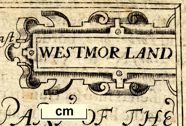
 Westmor Land

|

|
|
|
map type:- Bill 1626 |
|
|
|
Maps, Westmor Land, scale about 17 miles to 1 inch, and
Cumberland? probably derived from the map by Peter Keer,
1599, by John Bill, London, 1626.
Published in 'The abridgment of Camden's Britan~ia. With the Maps of the seuerall Shires of England and Wales. Printed by John Bill Printer to the Kings most Excellent Maiestie, 1626'. The map is copied from Saxton's map, and is like Keer's map; it has latitude and longitude scales on the west and south borders, this county map series is said to be the first to show lat and long; each map has the description of the next county on its reverse, so Hantshire has the description of Barkshire, though it is possible there was an edition with the text of Bucks and Oxon transposed; the atlas has a map of England with a general description, and a note on geography, the 1626 atlas size is 5 3/4 x 6 7/8 ins. |
||

|
Keer 1605 | |
|
(example map Armitt Library : ALMC2008.14.66)
|
||
| map feature:- | title cartouche & strapwork cartouche & swash lettering & up is N & scale line & lat and long scales (from the E) & sea moire effect & coast shaded & rivers & lakes & relief & hillocks & county & settlements | |
| inscription:- |
printed title cartouche, upper right
WESTMOR LAND |
|
| wxh, sheet:- | 19x14cm | |
| wxh, map:- | 121x84mm | |
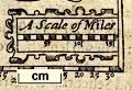
| scale line:- | 16 miles = 23.9 mm | |
| inscription:- |
printed above scale line
A Scale of Miles |
|
| scale:- | 1 to 100000 ? (1 1077385 to from scale line wrongly assuming a statute mile) | |
| longitude, Kendal:- | 24d 53m E (approx) | |
|
||
| references:- |
Camden, William (after): 1626: Abridgment of Camden's
Britannia: Bill, John (London) |
|
| sources:- |
Chubb 1927 (XLI) Skelton 1970 Armitt Library |
|
| items seen (illustrated items in bold):- | ||
|
|
Armitt Library : ALMC2008.14.66 -- map -- Westmor Land | |