 Keer 1605

|

|
|
|
map type:- Keer 1605 |
|
|
|
Map, Westmorlandia et Comberlandia, ie Westmorland and
Cumberland now Cumbria, scale about 16 miles to 1 inch,
probably by Pieter van den Keere, or Peter Keer, about 1605,
published about 1605 to 1676.
In their earliest state the maps have no text on the reverse. Published by William Jansson Blaeu in 'Guilielmi Camdeni, Viri Clarissimi Britannia, sive florentissimorum Regnorum Angliae, Scotiae, Hiberniae, & Insularum adjacentium ex intima antiquitate descriptio. In epitomen contracta a Regnero Vitellio Zirizaeo, & Tabulis chorographicis illustrata. Amstelredami, Ex officina Guilielmi Ianssonij, M.DC.XVII.' ie 1617. The 1617 atlas is effectively a 2nd edn of planned atlas by Peter Keer about 1605, which now exists as a few sets of plates in public and private collections. The maps have text abridged from William Camden's Britannia, in Latin, on the reverse. Plates are numbered lower right. Published in 'England Wales Scotland and Ireland Described and Abridged with ye Historic Relation of things Worthy memory from a farr larger Voulume Done by John Speed. Anno Cum privilegio 1620. And are to bee sould by Georg Humble at ye Whit horse in popeshead Alley.' 1620. The 1620 atlas has an illustrated title page, and text including a catalogue of shires, cities, etc etc; the atlas size is 5 x 3 5/8 ins. The 1620 map title is translated from the Latin of the 1617 map, which is otherwise unchanged, the scale line label is still in Latin; on the back of the 1620 map is text in English describing the county, abridged from Speed's atlas of 1611; there is additional text at the back of the atlas. There are editions and reprints of the atlas in 1627, 1630, 1646. Published in 'England Wales Scotland and Ireland Described ... And are to bee sould by Roger Rea the Elder & younger, at ye Golden Crosse in Cornhill against ye Exchange Anno cum privilegie 1662.' Published in an edition 1665; there is only one copy of this edition known (Chubb). Published in editions 1666, 1668, 1676. The 1676 edition has a half title page 'An Epitome of Mr John Speed's Theatre of the Empire of Great Britain. And of His Prospect of the Most Famous Parts of the World ... London, Printed for Tho. Basset at the George in Fleet street, and Ric. Chiswel at the Rose and Crown in St. Paul's Church-yard, 1676.' |
||
|
(map example, various sources)
|
||
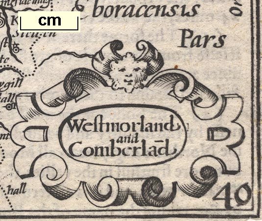
| map feature:- | title cartouche & strapwork cartouche & labelled borders & scale line & sea moire effect & coast line & coast shaded & rivers & lakes & relief & hillocks & county & settlements | |
| inscription:- |
(?1605 edn): printed title cartouche, lower left
Westmorlandia / et / Comberla~dia |
|
| inscription:- |
(1627 edn): printed title cartouche, lower left
Westmorland / and / Comberla~d |
|
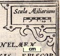
| scale line:- | 10 miles = 5/8 inch | |
| scale:- | 1 to 1000000 ? (from the scale line wrongly assuming a statute mile) | |
|
||
| references:- |
Blaeu, William Jansson: 1617: Guilielmi Camdeni, Viri
Clarissimi Britannia ...: (Amsterdam, Netherlands) : 1620: England Wales Scotland and Ireland Described and Abridged: Humble, George (London) : 1662: England Wales Scotland and Ireland Described: Rea, Roger snr & Rea, Roger jnr (London) Skelton, R A: 1950: Pieter van den Keere: Library, The: ser.5 vol.5: pp.130-32 Keuning, J: 1960: Pieter van den Keere: Imago Mundi: 15: pp.66-72 Wallis, Helen (intro): 1972: Atlas of the British Isles: Margary, Harry (Lympne Castle, Kent):: reproductions from the ?1605 edn Taylor, E G R (ed): 1951: Atlas of Tudor England and Wales, An: Penguin Books (Middlesex):: reproductions from the 1627 edn |
|
| sources:- |
Chubb 1927 (IX) Curwen 1918 private collection JandMN Collection HMCMS Map Collection Wordsworth Trust Collection Armitt Library Kendal Library Maps |
|
| items seen (illustrated items in bold):- | ||

|
Armitt Library : ALMC2008.14.4 -- map -- Westmorland and Cumberland | |
|
|
Dove Cottage : 2007.38.110 -- map -- Westmorland and Cumberland | |
|
|
Dove Cottage : 2007.38.111 -- map -- Westmorland and Cumberland | |
|
|
Dove Cottage : 2007.38.112 -- map -- Westmorland and Cumberland | |
|
|
JandMN (89) -- map -- Westmorland and Cumberland | |
|
|
Kendal Library : Map 35 -- map -- Westmorland and Cumberland | |
|
|
Kendal Library : Map 36 -- map -- Westmorland and Cumberland | |
|
|
Kendal Library : Map 38 -- map -- Northumberland | |
|
|
Kendal Library : Map 142 -- map -- Westmorland and Cumberland | |