 Keer 1605

|

|
|
|
item:- Armitt Library : ALMC2008.14.4 image:- © see bottom of page |
click to enlarge |
|
|
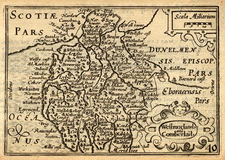
Map, uncoloured engraving, Westmorland and Cumberland,
scale about 16.5 miles to 1 inch, probably by Pieter van den
Keere, or Peter Keer, about 1605 edition 1620?
Included in England Wales Scotland and Ireland Described and Abridged ... from John Speed, by Georg Humble at ye Whit horse in popeshead Alley, 1620. The map title is translated from Latin; there is text on the reverse in English, part of the description of the county, abridged from Speed's atlas of 1611. |
||

|
Keer 1605 | |
| map feature:- | scroll cartouche & labelled borders (Latin) & up is N & scale line & sea moire effect & coast shaded & rivers & lakes & relief & hillocks & county & settlements | |
| inscription:- |
printed title cartouche, lower right
Westmorland / and / Cumberland |
|
| scale line:- | 10 miles = 15.2 mm | |
| scale:- | 1 to 1100000 ? (1 to 1058779 from scale line) | |
| wxh, sheet:- | 15.5x9.5cm | |
| wxh, map:- | 122x84mm | |